
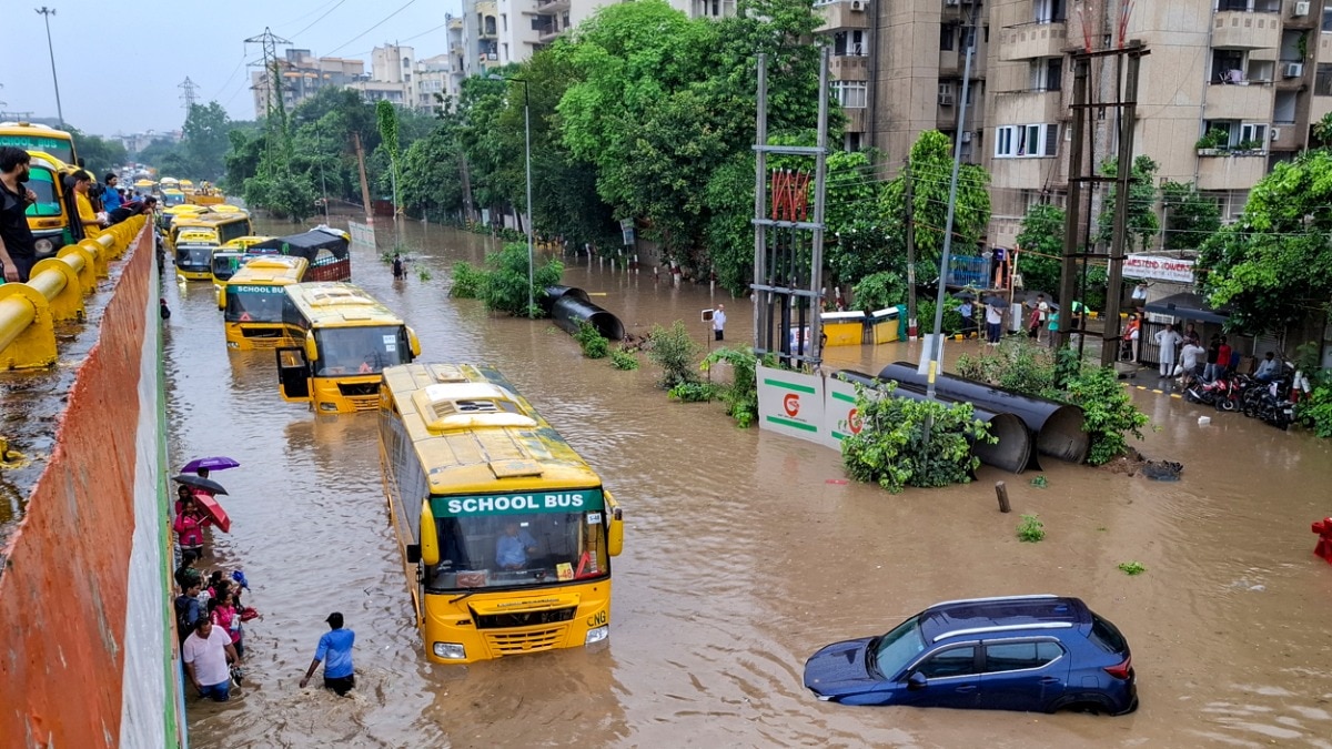
As always, heavy rain this week left Gurugram's roads submerged, schoolchildren stranded, and commuters wading through waist-deep water. Meanwhile, Delhi's other satellite city, Noida, fared much better. What's behind the contrast?"Gurgaon waale, ab toh Noida aa jao...," a person wrote as she put this up on her Instagram story on Monday evening as heavy rain lashed the NCR. Noida residents, often summoned by friends to Haryana's Gurugram for weekend parties, had the last laugh. But Gurugram's monsoon misery is not a matter of a joke. Each spell of rain brings the Millennium City to its knees, with neighbouring Dwarka in Delhi yielding similar scenes. Come monsoon, why do the NCR's two satellite cities fare so differently? We also examine Dwarka, Delhi's own planned satellite settlement, to understand what went wrong for Gurugram and Dwarka, and what worked for Noida.After rain lashed the NCR on Monday and Tuesday, visuals showed waterlogged roads, underpasses filled to the brim and people wading through knee-deep water. In Gurugram, a school bus dropping children home got stranded in a pool-like road. The children, visibly shaken and seen sobbing, had to take shelter in a nearby shop, and had to be rescued by their parents, who, too, rushed in, wading through waist-deep rainwater. The bus had to be rescued using a crane.By Wednesday morning, we had seen another visual from Gurugram. It was that of a crater on a road, arguably bigger than one on the Moon. And, as usual, the political blame game kicked off. Gurugram's BJP MP blamed the Congress, though he himself was a Congress MP when first elected from Gurugram in 2009.Likewise, neighbouring Dwarka witnessed severe waterlogging and urban flooding. A small note here. Both Gurugram (earlier Gurgaon) and Noida are products of the same post-liberalisation NCR boom. But the cities in Haryana and Uttar Pradesh were not built in the same way.Noida was built in a more orderly manner, with the authorities laying roads, sewers and major drains before opening up land for construction. Gurugram expanded differently. Private colonies and gated complexes rose faster than the public infrastructure needed to support them. Gurugram also has multiple civic bodies handling interconnected services across different jurisdictions.So blame always follows another. Likewise, in Delhi, Dwarka was planned too. But clogged and encroached drains, incomplete links of stormwater drains and Delhi's outdated drainage planning have eroded the planning advantage.Here, we examine the three broad factors behind the stark mismatch between Noida and Gurugram. We will also look at why the planned Dwarka faces similar monsoon misery.1. NOIDA BUILT ITS DRAINS BEFORE ITS TOWERS. DID GURUGRAM DO SO?Noida benefits from having two sizeable rivers, the Hindon and the Yamuna, as final outfalls for its storm water network. Gurugram has no such river outlet within the city and depends on three principal drains that ultimately empty into the Najafgarh drain, once part of the Sahibi River system but now essentially a sewage-laden channel.Then, the Aravallis along Gurugram's east and south-east send run-off rapidly downhill into the city. When its drains are clogged or constricted, water accumulates on roads and in low-lying areas.While Gurugram has hundreds of kilometres of internal and sector-level drains, its trunk network (the large channels that finally carry water out of the city) is limited and overwhelmingly dependent on the Badshahpur drain. According to the Gurugram Metropolitan Development Authority (GMDA), rainwater is supposed to flow westwards from the Aravallis towards the Najafgarh drain in the east, through three main channels. One of them is the Badshahpur drain. Together, these are meant to carry water from large parts of Gurugram, crossing railway lines and highways before reaching the Najafgarh drain.In a discussion with India Today TV's Rajdeep Sardesai, environmental conservationist Vaishali Rana said Gurugram had around 550km of storm water drains, but alleged that most were encroached upon or lacked effective outlets."Today, Gurugram has about 550 kilometres-odd of storm water drains, most of which are encroached on... There is no outlet for the storm water, for the rainwater to get out of Gurugram," said Rana, who's also a trustee of the Aravalli Bachao Citizens Movement.But the drain also receives untreated sewage and has been narrowed or blocked at several points by encroachments and permanent structures."Badshahpur nallah has become a kooda nallah, a sewage drain, and its carrying capacity has been severely compromised," Rana told India Today TV, alleging that 18km of its 28km course was closed or had been lost to encroachment.Noida, too, witnesses waterlogging. Low-lying stretches, underpasses and sectors with clogged local drains can flood during intense rain. But the difference here is that water generally recedes faster because the local drains are connected to an extensive trunk network that discharges into rivers like Yamuna and Hindon.Architect and town planner Archit Pratap Singh explained this distinction to India Today in 2023. In Noida, he said, the Authority generally provided land with basic infrastructure before releasing it for residential or commercial construction."Unlike Gurugram, Noida's land acquired by the authorities gets basic amenities like electricity, road and sewer first before it is made available for residential or commercial purposes," Singh said.Gurugram largely did the reverse. Houses, office towers and gated complexes rose before a citywide drainage network capable of supporting them could be ready. 2. GURUGRAM IS BUILT OVER ITS OWN NATURAL DRAINAGEGurugram's topography was not always a disadvantage. Water naturally descended from the Aravalli foothills in the east and the southeast towards the Najafgarh basin in the northwest.The elevation difference (estimated at 60 to 78 metres) created a natural slope that carried rainwater away. For generations, ponds, seasonal channels, check dams, baolis, and baandhs slowed this water, stored some of it and allowed it to seep into the ground."The way the city is located geographically, topographically, is fantastic... Water follows the topography of the land," architect and urban designer Dikshu C Kukreja told India Today TV.That natural system was disrupted as Gurugram expanded. Ponds were filled, drainage channels encroached upon and vast stretches of soil replaced with concrete.Union Housing and Urban Affairs Minister Manohar Lal Khattar, former Haryana chief minister, acknowledged the damage in a Lok Sabha reply in August 2025.Citing information from the Haryana government, Khattar said the approximately 78-metre elevation difference between the Aravallis and the Najafgarh drain had created a natural gradient for water flow. Rapid urbanisation, the minister said, had rendered many of them obsolete and reduced the pond network, damaging Gurugram's traditional drainage system.The Sahibi River, village ponds, wetlands and Aravalli channels are either clogged or built over as Gurugram grew into a corporate hub.Rana told India Today TV that forest department records once listed around 110 check dams in Gurugram, of which she claimed fewer than 20 remained. She also said that more than half the city had been concretised. These numbers could be her assertions, but the disappearance of bunds and ponds has been acknowledged by the government itself.Concretisation of Gurugram makes the problem worse. Rainwater that earlier seeped into the earth. But now, the rainwater is forced to race towards the drains that are clogged and compromised. Many drains don't even meet a bigger drain. Some, even if they meet, have leakages or are clogged.Shiv Singh Rawat, a retired superintending engineer with Haryana's Irrigation and Water Resources Department, called it a "long-term failure" of the administration."Planning has totally failed and drainage was never a part of the development," Rawat told India Today TV. Concretisation, he said, had reduced the soil's ability to absorb water, creating rapid run-off that rushes and accumulates in urban depressions, underpasses and along major roads. Google Street View and Google Earth imagery show the Sahibi River's narrow stretch at the Gurgaon-Delhi border, choked with hyacinth and caked with dirt. (Images: Google Street View and Google Earth) 3. GURUGRAM GREW AS DISCONNECTED ISLANDS, NOIDA WAS BETTER PLANNEDNoida was developed largely by one public authority that acquired contiguous land and laid trunk infrastructure. Gurugram's growth was more fragmented, with private developers like the DLF creating colonies and commercial districts around older villages and roads."The developer has just purchased the land from the farmer, got the land use converted and then gone about building his own isolated silo," architect and urban designer Dikshu C Kukreja told India Today TV.These "islands of excellence", he said, had failed to account for the public infrastructure outside their boundary walls.The consequences, therefore, are visible during rain. A gated complex might have internal drains and pumps, but the water eventually enters a road or drain that might be undersized, blocked or disconnected from the master network.The governance structure of this public infrastructure in Gurugram is equally fragmented. The Gurugram Metropolitan Development Authority manages master services, including the main drainage network, while the Municipal Corporation of Gurugram handles local infrastructure. The PWD, HSVP, NHAI, HSIIDC, the irrigation department and private developers control other stretches and assets.These agencies do not perform the same jobs, but their services are interconnected. A local drain is useless if it is not connected to the master drain. A highway drain cannot function if the smaller receiving channel is blocked.The Hindustan Times reported in 2021 that jurisdictional issues involving GMDA, MCG, HSVP, NHAI and the Town and Country Planning Department had caused confusion and stalled projects. In 2025, NHAI asked Haryana to place drainage around the Delhi-Gurugram Expressway under one agency because the involvement of multiple bodies was impeding coordination, reported The Times of India.The result is predictable and is in front of our eyes. One body points towards another and no single authority bears full accountability for the entire system. And, this urban mess does not stop at the Gurugram border. Neighbouring Dwarka, despite being a planned sub-city, is battling a similar drainage mess.A large section of road suddenly caved in at IFFCO Chowk, one of Gurugram's busiest intersections, on the stretch connecting MG Road towards Gurugram, creating a roughly 25-foot-wide pit and triggering panic among commuters.The incident occurred during a busy period, raising pic.twitter.com/Zu3GtwAHfK— IndiaToday (@IndiaToday) August 26, 2026WHY PLANNED DWARKA FLOODS TOONot just Gurugram, neighbouring Dwarka also exhibits that a planned settlement cannot protect a city from its drainage woes. The Delhi Development Authority-built sub-city has broad roads and several trunk drains. Like Gurugram, Dwarka lies along the Sahibi river, now reduced to a drain with virtually no floodplain to absorb excess water when rainfall swells.A drainage network is only as effective as its links and outlets. The Times of India in August 2025, citing an official assessment, reported encroachments had blocked drainage lines in parts of Dwarka.Dwarka, connected to Delhi's drainage system, continues to be shaped by a master plan prepared in 1976, when the capital's population was around six million. An 2018 IIT Delhi assessment described the capital's storm water infrastructure as dilapidated and noted that its population had grown more than threefold since that plan was prepared.The Times of India, earlier this month, reported that a study called, Environmental Improvement Plan of Delhi, said, unplanned construction, higher surface runoff, reduced groundwater recharge and poor drainage have steadily weakened the capital's ability to handle intense rain.Reporting on the plan, the report specifically noted that encroachments had blocked drainage lines in Dwarka, while Delhi's 3,642-km drainage network was divided among agencies such as PWD, MCD, DDA and the Irrigation and Flood Control Department.So, to sum up, Noida has not beaten the monsoon. There's waterlogging in Noida too. But it has given rainwater a clearer way out and doesn't usually get submerged. Neighbours Gurugram and Dwarka, meanwhile, had built drainage systems haphazardly or had to use the drains that existed earlier. The drains became everyone's responsibility. And therefore no one's. Until that changes, every heavy shower will bring back the same flooded roads, stranded vehicles and the question, where is all this water supposed to go?- EndsPublished By: Sushim MukulPublished On: Aug 26, 2026 15:47 IST
Why Gurugram drowns in rains, but Noida doesn't. 3 key factors
Full Article
Original Source
Read the full article at Indiatoday →KhanList aggregates and links to publicly available news content. We do not host full articles from third-party sources. Always verify important information with original sources.