
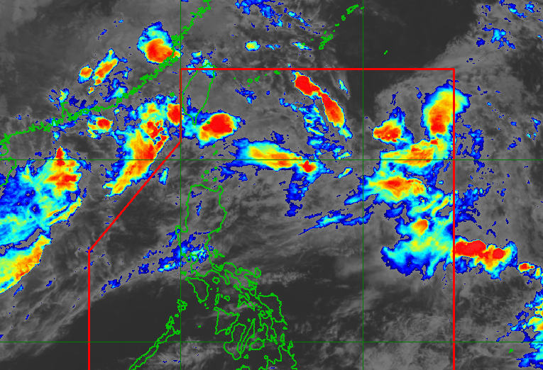
WEATHER. Tropical Storm Pilandok and southwest monsoon inside the Philippine Area of Responsibility as of September 2, 2026, 5 pm. PAGASA The enhanced southwest monsoon is affecting Luzon and the Visayas, while the haze from Indonesia is currently affecting western sections of the Visayas and Mindanao Tropical Storm Pilandok is enhancing the southwest monsoon and is expected to exit the Philippine Area of Responsibility by early Thursday, September 3. Tropical Storm Saudel is gradually weakening as it moves toward southern China and may not reenter the Philippine Area of Responsibility, while another low pressure area is being monitored with a low chance of developing into a tropical depression. The southwest monsoon is causing moderate to heavy rain in several provinces, with warnings for potential floods and landslides. Haze from Indonesia is affecting air quality in parts of the Visayas and Mindanao. This is AI-generated. Read the article for full context. Report any errors. MANILA, Philippines – Tropical Storm Pilandok (Krovanh), which is enhancing the southwest monsoon or habagat, may exit the Philippine Area of Responsibility (PAR) by early Thursday, September 3. The Philippine Atmospheric, Geophysical, and Astronomical Services Administration (PAGASA) said in its 5 pm bulletin on Wednesday, September 2, that the tropical storm was last located 1,085 kilometers east northeast of extreme Northern Luzon, moving west northwestward at 14 kilometers per hour, with maximum sustained winds of 65 km/h and gustiness of up to 80 km/h. It still has no direct effect on the country, far from the Philippine landmass, and is unlikely to make landfall, remaining over the northern Philippine Sea as it moves toward Okinawa, Japan. Tropical Storm Saudel (formerly Obet), meanwhile, was located 460 km west northwest of Itbayat, Batanes, with the same strength as Pilandok’s (winds of 65 km/h, gustiness of up to 80 km/h), moving east northeastward at 20 km/h. PAGASA Weather Specialist Benison Estareja said Saudel is gradually weakening as it moves toward southern China, and there is a high chance that the tropical storm will no longer enter PAR, although if it does reenter, it would only be for a while and as a tropical depression. The weather bureau is monitoring another low pressure area (LPA) 2,745 km east of Central Luzon, with a “low” chance of developing into a tropical depression. These weather disturbances continue to enhance the southwest monsoon or habagat. Ilocos Norte, Ilocos Sur, La Union, Pangasinan, Abra, Benguet, Zambales, and Bataan are seeing moderate to heavy rain (50-100 millimeters) on Wednesday afternoon due to the southwest monsoon. The rain will ease in some provinces and affect only Zambales, Bataan, Cavite, Batangas, and Occidental Mindoro on Thursday afternoon before heavy to intense rain (100-200 mm) is seen again in Occidental Mindoro and moderate to heavy rain in Zambales, Bataan, Pampanga, Cavite, Batangas, Oriental Mindoro, and Antique on Friday afternoon. These provinces should watch out for floods and landslides. The southwest monsoon is also bringing strong to gale-force gusts, especially in coastal and upland areas exposed to winds, over most of Luzon and the Visayas, Zamboanga del Norte, Misamis Occidental, Lanao del Norte, Misamis Oriental, Camiguin, Dinagat Islands, Davao Occidental, and Davao Oriental. Moderate to very rough seas will persist in the following areas: Up to very rough seas (travel is risky for all vessels) Seaboard of Batanes; the northern and western seaboards of Babuyan Islands — waves up to 5 meters high Seaboards of Ilocos Norte and northern Ilocos Sur — waves up to 4.5 meters high Up to rough seas (small vessels should not venture out to sea) Seaboard of northern La Union; the western seaboard of Pangasinan — waves up to 4 meters high Seaboard of Zambales; the western seaboard of Bataan — waves up to 3.5 meters high Seaboard of Lubang Islands; the northern and western seaboards of Calamian Islands and Kalayaan Islands; the southern seaboard of Bataan; the western seaboards of Cavite, Batangas, and northern Occidental Mindoro; the remaining seaboard of Babuyan Islands — waves up to 3 meters high Up to moderate seas (small vessels should take precautionary measures or avoid sailing, if possible) Seaboards of Isabela and southern Surigao del Sur; the remaining western seaboard of Palawan; the eastern seaboard of Davao Oriental; the remaining seaboards of La Union, Pangasinan, and Kalayaan Islands; the northern seaboard of mainland Cagayan; the remaining western seaboard of Occidental Mindoro — waves up to 2.5 meters high Seaboards of northern Aurora, Romblon, Cuyo Islands, Cagayancillo Islands, Antique, and Davao Occidental; the southern seaboards of Quezon, Marinduque, Iloilo, and Guimaras; the eastern and southern seaboards of Oriental Mindoro; the western seaboard of southern Negros Occidental; the remaining seaboards of mainland Cagayan, northern Palawan, Occidental Mindoro, Surigao del Sur, and Davao Oriental — waves up to 2 meters high Haze, September forecast Due to the southwest monsoon, too, smoke and fine particles from Indonesia are being pulled toward the western sections of the Visayas and Mindanao, resulting in haze as of Wednesday morning, with Mindanao seeing thicker haze than on Tuesday, September 1. Estareja said the haze started on Sunday, August 30, in Palawan, affecting Metro Manila and nearby provinces in Southern Luzon on Monday, August 31, then Southern Luzon and the Visayas on Tuesday. PAGASA is seeing improving air quality as the wildfires weaken for now. PAGASA advised those in affected areas to wear N95 or KF94 face masks outdoors, or stay indoors if possible. Meanwhile, occasional heavy rain and strong winds due to the southwest monsoon and LPAs remain prevalent in September, but easterlies may prevail toward the end of the month, weakened by El Niño. Two to three tropical cyclones are expected to enter PAR in September. The country has had 16 tropical cyclones so far in 2026, with five to nine more expected in the next four months. The tropical cyclones in September (to be named Queenie, Rosal, and Samuel) may make landfall over Luzon or enhance the southwest monsoon. – Rappler.com How does this make you feel? Loading
Tropical Storm Pilandok may exit PAR on September 3
Full Article
Original Source
Read the full article at Rappler →KhanList aggregates and links to publicly available news content. We do not host full articles from third-party sources. Always verify important information with original sources.