
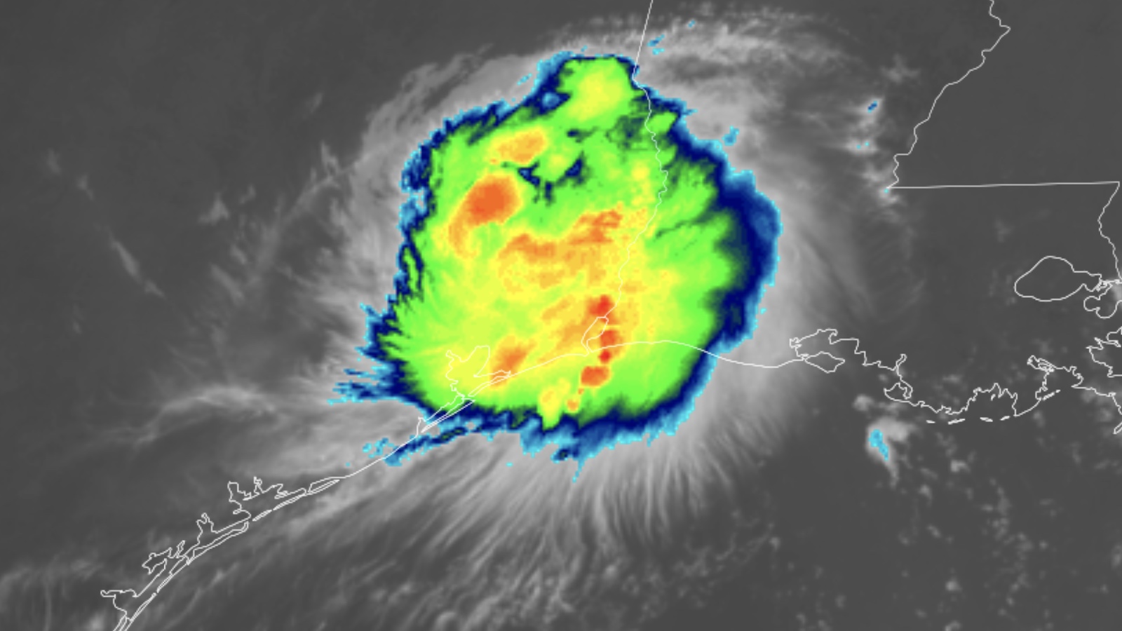
Enhanced infrared satellite image of Tropical Depression Edouard over eastern Texas at 1410Z (9:10 a.m. CDT) Wednesday, September 2, 2026. (Image credit: RAMMB/CIRA/CSU) Wednesday’s landfall of short-lived Tropical Storm Edouard on the southeast Texas coast may have seemed as mercifully benign as it gets, but its rains have ended up causing more trouble than expected well inland. Although the National Weather Service National Hurricane Center has ceased advisories on Edouard, a corridor of intense rains was causing locally catastrophic flooding. Edouard was drifting northward as a depression at midday Wednesday with top sustained winds of 35 mph. The NWS Weather Prediction Center alerted residents in a broad swath from roughly Houston and Beaumont-Port Arthur to Dallas-Fort Worth of the risk of flash flooding on Wednesday, with a top-end threat at the center of this swath over parts of far east Texas. Additional major flash flooding could erupt on Wednesday afternoon and evening as Edouard crawls northward. The towns of Kountze, Village Mills, and Honey Island were placed in a flash flood emergency around dawn on Wednesday. Among the highest 24-hour rainfall amounts reported in the CoCoRaHS network as of early Wednesday morning were nine inches near Woodville, 7.97 inches near Livingston, and 6.99 inches near Beaumont. Doppler radar estimates of rainfall ranged from five to 20 inches in parts of Tyler and Hardin counties, according to the National Weather Service. Some such rainfall estimates were approaching 30 inches by midday. Flash flood EMERGENCY is in effect in Hardin and Tyler Counties, Texas, where 15-28 inches of rain have fallen.Rainfall rates up to 6 INCHES PER HOUR!A stout Gulf moisture tongue allowed Edouard to maintain structure/strength farther inland. @MatthewCappucci updates: pic.twitter.com/zLZsxzsSlq— MyRadar Weather (@MyRadarWX) September 2, 2026 According to NHC, Edouard made landfall near Johnson Bayou, Texas, at 2:20 p.m. CDT Tuesday, September 1, with top sustained winds estimated at 60 mph (95 km/h). The storm’s compact size means that its peak winds over land could have occurred in between reporting stations. No major wind-related or storm surge destruction was reported. Just before landfall, sustained winds at the easternmost point on the Texas Gulf Coast – the aptly named Texas Point, Texas, – reached 57 mph (93 km/h), gusting to 71 mph (114 km/h). Still no Atlantic hurricane in 2026 thus far After Edouard, no other systems are showing signs of tropical development in the Atlantic over at least the next week – through September 9 – according to NHC’s Tropical Weather Outlook issued on Wednesday morning. As discussed by Michael Lowry in his Tuesday Substack post, assuming we finish this week without a hurricane, 2026 will rank fifth for the latest-forming first hurricane of the satellite era. The latest date of the first Atlantic hurricane since 1950 is September 11 (Humberto in 2013 and Gustav in 2002). The average date for the first Atlantic hurricane is August 11, and we should have already had two hurricanes by now. Interestingly, the U.S. averages three landfalls by named storms per year (with two of them being hurricanes). With the season almost half over, we’ve already had three landfalls: Arthur, Bertha, and Edouard. One of these, Arthur, was a billion-dollar storm. Figure 1. Hurricane Lowell, Hurricane Karina, and Tropical Storm Marie (left to right) churn across the tropical Central and Eastern Pacific at 1530Z (11:30 a.m. EDT) Wednesday, September 2, 2026. (Image credit: RAMMB/CIRA/CSU) A slingshot path may send Lowell toward Hawaii next week Hurricane Lowell has become a true behemoth in the tropical Pacific. Centered about 455 miles (730 kilometers) south-southeast of Hilo, Hawaii, as of 5 a.m. HST (11 a.m. EDT) Wednesday, Lowell was packing top sustained winds of 155 mph (250 km/h), just below the Category 5 threshold. Lowell has intensified at a truly frenzied pace, going from Cat 1 to high-end Cat 4 in just 24 hours, a gain of 75 mph (120 km/h) in sustained winds. Within a 500-mi (800-km) radius of Lowell, extending up to the Island of Hawaii, only four Category 5 hurricanes have ever been reported: Emilia, Gilma, and John – all in 1994 – and Lane in 2018. NHC was predicting that Lowell would join this elite group later on Wednesday. Lowell is benefiting not only from the near-record oceanic warmth spawned by the ongoing strong El Niño event (sea surface temperatures along Lowell’s path are around 1-2 degrees Celsius or 2-4 degrees Fahrenheit above average) but also from a sustained period of light wind shear, expected to average only about 5 knots for at least the next five days. Lowell is also expected to dodge any large areas of midlevel dryness, with relative humidity expected to hold in the 55-65 percent range for at least the next five days. Sea surface temperatures will remain above 28°C (82°F) along Lowell’s path, more than warm enough to sustain a high-end hurricane. With all this in mind, Lowell will likely maintain most of its strength into the upcoming weekend, weakening only gradually early next week. Huge swells can be expected to reach Hawaii over the next few days. A more serious concern is the threat foreseen by long-range models for days, one that’s now showing up in official NHC forecasts, of a sharp right-hand turn northward starting this weekend. The exact timing and sharpness of this 90-degree turn, and Lowell’s forward speed after it makes the turn, will be critical in determining whether Lowell might pose any landfall threat to any of the Hawaiian islands. As of Wednesday, a substantial number of European-model ensemble members were projecting that Lowell would cross the island chain, potentially while still at hurricane strength. Marie bears watching for a slim chance of Southwest U.S. impacts Another powerhouse Pacific storm could affect a different part of the United States next week. Tropical Storm Marie, predicted to be a hurricane by Wednesday night, will continue paralleling the coast of Mexico several hundred miles offshore into this weekend. Marie is expected to reach at least Cat 2 strength as it heads northwest. There’s high uncertainty on what will happen when Marie hits a meteorological fork in the road early next week, when Marie or its remnants will either get pulled rightward toward Southern California and the Desert Southwest (possible but not likely) or shunted leftward away from the U.S. Coast (the more likely possibility). Even with El Niño in place, the waters between Marie’s track and Southern California are too cool to sustain a full-blown hurricane. However, remnant moisture could certainly bring unusual September rains to the region if Marie takes that right turn (which depends on weather features that are still evolving right now). It’s not absolutely impossible that a storm like Marie could make landfall as a tropical system between Santa Barbara and San Diego, but that would be a once-in-a-generation occurrence, highly unlikely to play out. Jeff Masters and Irene Sans contributed to this post. Republish our articles for free, online or in print, under a Creative Commons license. Bob Henson is a meteorologist and journalist based in Boulder, Colorado. He has written on weather and climate for the National Center for Atmospheric Research, Weather Underground, and many freelance... More by Bob Henson
Edouard delivers an outsized flash-flood punch to eastern Texas
Full Article
Original Source
Read the full article at Yaleclimateconnections →KhanList aggregates and links to publicly available news content. We do not host full articles from third-party sources. Always verify important information with original sources.