
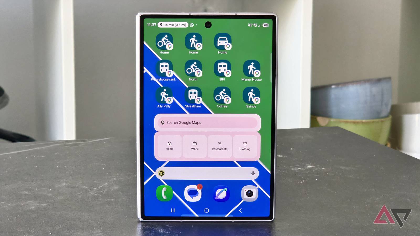
Published Aug 14, 2026, 3:00 PM EDT Tom has been covering technology since 2019, having worked as part of the phones team at TechRadar and then as an editor at What to Watch. Since 2025 he’s been a freelance contributor for many more brands including Digital Trends. BGR, TechRadar Gaming, TechAdvisor and GamesRadar. He's written about myriad topics over his career including phones and tablets, headphones and earbuds, fitness and AV, and enjoys adding more beats to his repertoire. Outside of technology he’s also written reviews and features on games, movies and sports, having worked for many years as an editor at movie & TV website WhattoWatch. He's attended tech launches, product shows, movie premieres and game launches to do so. Tom is based in London, UK, and when not covering technology he does work in the film sector, enjoys to run, cycle, climb and play tennis, and plays several instruments. My Google Maps routine used to have too many steps. I'd have to find the home screen folder the app was in, open it, wait for it to load, type in a search query, correct the app when it found the wrong location, and finally press Directions to get anywhere. That was, until I discovered a useful Google Maps feature that let me cut down on 90% of that process. It greatly reduced the amount of time I spent in the app. That's because I now know how to create Google Maps home screen shortcuts. They've changed how I use my phone to navigate around my city. Quiz 8 Questions · Test Your KnowledgeGoogle Maps routinesTrivia challenge From street view to offline maps — how well do you really know your way around Google Maps? NavigationFeaturesHistorySettingsExplore Begin In what year did Google officially launch Google Maps to the public? A2003B2004C2005D2006 Correct! Google Maps launched in February 2005, originally as a desktop web application. It was built using a then-novel technique of loading map tiles without refreshing the whole page, which felt revolutionary at the time. Not quite — Google Maps launched in February 2005. It began as a desktop browser tool and grew rapidly, with the mobile app following years later as smartphones became mainstream. Continue What is the name of the Google Maps feature that lets you explore a location through 360-degree ground-level photography? AEarth ViewBTerrain ModeCStreet ViewDPanorama Walk Correct! Street View launched in 2007 and uses a fleet of specially equipped vehicles, trekkers, and even underwater cameras to capture 360-degree imagery. It now covers millions of miles across more than 100 countries. The correct answer is Street View. Launched in 2007, Street View uses 360-degree cameras mounted on cars, backpacks, and even boats to capture immersive ground-level imagery from around the world. Continue Which of the following traffic data inputs does Google Maps use to calculate real-time travel times? ASatellite imagery refresh ratesBAnonymized location data from usersCRadio frequency signals from road sensors onlyDManual reports submitted by city councils Correct! Google Maps aggregates anonymized, real-time location data from users who have location services enabled. This crowdsourced approach lets it detect slowdowns, accidents, and congestion dynamically and update routes accordingly. The answer is anonymized location data from users. Google Maps pools movement data from millions of active users to understand traffic conditions in real time, allowing it to reroute drivers away from jams as they develop. Continue What must you do before you can use Google Maps navigation reliably in an area with no internet connection? AEnable satellite modeBDownload offline maps for that regionCConnect to a Bluetooth GPS deviceDTurn on Wi-Fi calling Correct! Google Maps allows you to download specific regions for offline use. Once downloaded, you can navigate turn-by-turn without a data connection, though real-time traffic and some search features won't be available offline. The right answer is downloading offline maps. By saving a region to your device in advance, Google Maps can still provide navigation without an internet connection — handy for travel abroad or areas with poor signal. Continue What is the purpose of the 'Your Timeline' feature in Google Maps? AIt shows upcoming events near your locationBIt displays a personal history of places you have visitedCIt tracks the live location of friends and familyDIt suggests new restaurants based on trending visits Correct! Your Timeline is a private log of places you have been, built from your Location History if it is enabled. It can show routes traveled, time spent at locations, and even photos taken at those places. The answer is that Your Timeline shows a personal history of places you have visited. It draws on your Location History data to reconstruct past trips and visits, and is only visible to you unless you choose to share it. Continue Which Google Maps layer helps cyclists by highlighting dedicated bike lanes, trails, and elevation changes on a route? AEco-friendly layerBCycling layerCTerrain overlayDActive commute view Correct! The Cycling layer overlays bike-friendly infrastructure on the map, including dedicated lanes, bike paths, and elevation data. It helps cyclists plan safer and more comfortable routes before setting off. The correct answer is the Cycling layer. Accessible from the map layers menu, it highlights bike lanes, trails, and elevation so cyclists can plan the safest and least strenuous route to their destination. Continue When using Google Maps for driving navigation, what does the green bar shown along a highlighted route typically indicate? AThe route passes through an eco-zoneBThere is currently no significant traffic on that segmentCToll roads are present on that sectionDThe route has been verified by local authorities Correct! In Google Maps, green segments along a route indicate free-flowing traffic with no significant delays. Orange suggests moderate slowdowns, while red flags heavy congestion — helping drivers quickly assess their journey at a glance. The answer is that green indicates no significant traffic on that segment. Google Maps uses a color-coded system — green for clear, orange for slow, and red for heavy traffic — so you can read road conditions at a glance before or during your trip. Continue Which company's mapping technology did Google originally license before building its own mapping infrastructure? AMapQuestBTomTomCWhere 2 TechnologiesDNavteq Correct! Google Maps grew out of a C++ desktop program created by Where 2 Technologies, a startup that Google acquired in 2004. The founders, Lars and Jens Rasmussen, helped transform that technology into the web-based Google Maps we know today. The answer is Where 2 Technologies. Google acquired this Australian startup in 2004, and the brothers who founded it — Lars and Jens Rasmussen — played a key role in developing the original Google Maps product from the ground up. See My Score Challenge CompleteYour Score / 8 Thanks for playing! Try Again What Google Maps shortcuts am I even talking about? They're a well-hidden feature You can add shortcuts onto your phone's home screen. When tapped, they open Google Maps and instantly bring up directions to a set location. No typing, no pressing methods of transport. You immediately know your route. Google Maps has several home screen shortcuts, like the ability to monitor nearby traffic or share your location with a friend. But as someone who only uses Maps to navigate, I haven't played around with these much. You can't set these up in Google Maps. They're a little hidden away, and it's why it took me years to discover they existed. But I'll let you in on a little secret. How to set up Google Maps home screen shortcuts It's simpler than you'd expect So that we're on the same page, I'll talk you through how to set up home screen shortcuts for Google Maps locations on your phone. This way, you can play about with them to understand what I'm talking about. These shortcuts are, in effect, widgets. You add them in the same way: press and hold an empty spot on your phone's home screen, select Widgets, scroll down and select Maps, tap Directions, and tap Add. Next, you'll fill in some fields: the location you want your shortcut to take you to (for example, your home address), the shortcut's name that'll appear on your home screen (for example, "Home"), and the type of transport you'll be using. Finally, press Save, and the shortcut appears on your phone's screen. Its icon reflects the method of transport: a tram for public transport, a bike for cycling, for example. You can set up multiple shortcuts to the same location with different transit this way. Avoid the Google Maps feature creep Every time I open Google Maps, it's to find my way somewhere. While some use Google Maps to discover their neighborhood or create lists of destinations to visit, I only want to know which street or bus to take to get somewhere. These social tools often get in my way when I'm trying to navigate. I'll try to find my way to a restaurant, but instead will be told its rating, menu, table availability, whether commenters think it has a "chill vibe" or smells nice. But with these Google Maps shortcuts, I can bypass the noise entirely, and get what I want: directions. Pure and simple. Soon after discovering the home screen shortcuts, I found myself letting loose a little bit. I initially started with one widget: a button I could press to navigate home on public transport, from wherever I was. This was the single useful widget that sold me on the shortcuts. I often venture to different parts of my city, and live in a borough with unreliable public transit. I can't rely on the same bus or train line, and Google Maps could cater for the changing whims of the transit. Slowly, I began to add links to other parts of the city I visit frequently. My partner's house was the first, and I've since added a few more for the coffee shops, bars, and theaters I frequent. I have different widgets for different modes of transport. Depending on the day, I might want to navigate home on my bike, on foot, or on public transport. Having three widgets lets me leap straight to the appropriate route. It's also possible, for chain locations, to set up a widget to show you all nearby franchises. I have one that shows me local supermarkets, so I always know where I can pick up my bread and cheese. If you're a busy person and frequently travel between set locations, these Google Maps home screen shortcuts are a vital tool. A single press of a "Work" shortcut could tell you the best route to your office and inform you of public transport works or traffic en route. The same is true of the homes of loved ones, your gym, or a favorite getaway destination. All this while saving loads of time that you'd usually waste on Google Maps? That sounds like a win to me, and it's why I use them so much. Just as how I'm replacing home screen apps on my phone, the Google Maps app is being forgotten for widgets.
This simple Google Maps tool has totally changed how I navigate with my phone
Full Article
Original Source
Read the full article at Androidpolice →KhanList aggregates and links to publicly available news content. We do not host full articles from third-party sources. Always verify important information with original sources.