
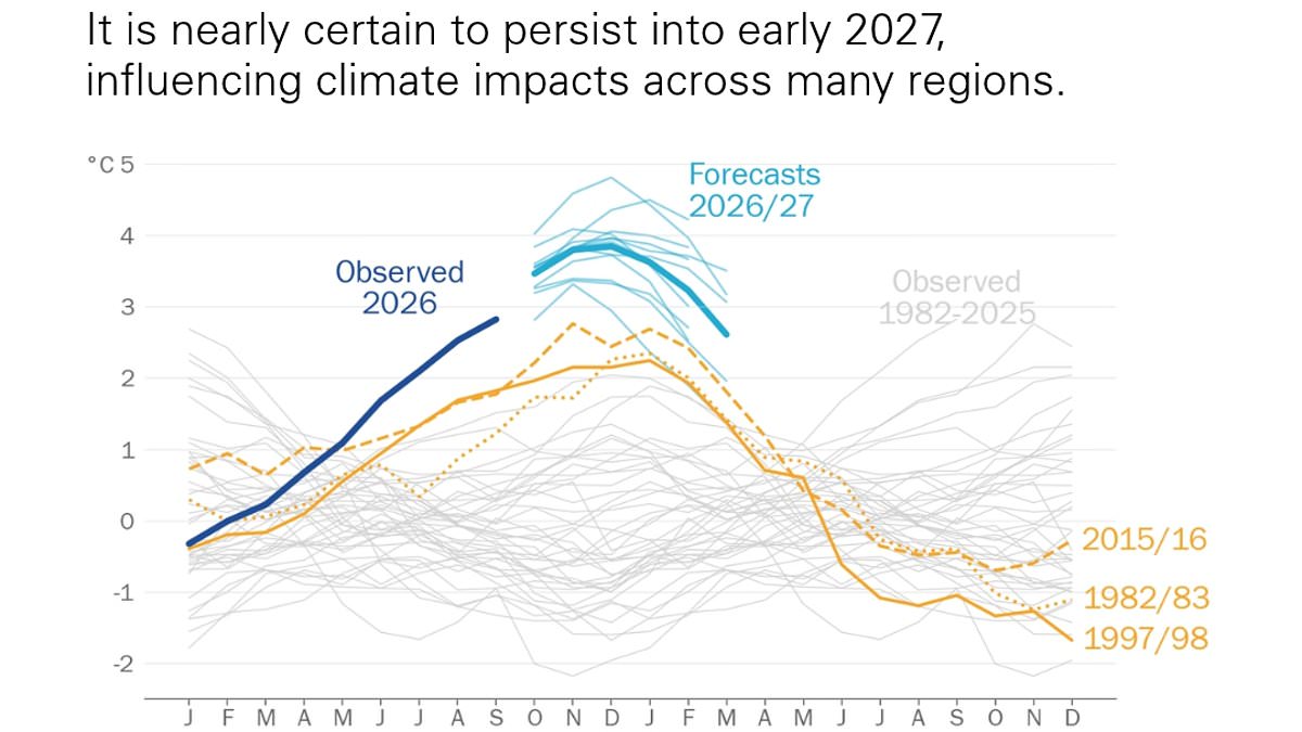
Super El Niño is 'off the charts', and has even started to 'supercharge' our weather, experts from the World Meteorological Organisation (WMO) have warned.The WMO State of the Climate Update 2026 reveals how the extreme climate event has already been linked to exceptional global temperatures, melting ice, and rising sea levels. What's more, the worst is yet to come – with El Niño set to unleash even more heat and extreme weather well into 2027, they say. 'We have entered a new age of climate extremes,' said UN Secretary–General António Guterres.'A supersized El Niño is colliding with a planet already superheated by manmade climate change. 'Climate records keep falling. The human costs keep rising. And those least responsible are suffering first and worst.'Leaders must get serious by cutting emissions faster, accelerating a just transition from fossil fuels and delivering the finance and protection vulnerable countries need.' Super El Niño is 'off the charts', and has even started to 'supercharge' our weather, experts from the World Meteorological Organisation (WMO) have warned From January to September this year, the global average surface temperature was about 1.47°C above the pre–industrial average. That's comparable to the whole–year averages for 2025 (1.43°C) and 2023 (1.46°C), although it is slightly lower than the 2024 record (1.55°C)According to the report, the past 12 years have individually been the warmest on record – with the past four being the top four. From January to September this year, the global average surface temperature was about 1.47°C (2.64°F) above the pre–industrial average. That's comparable to the whole–year averages for 2025 (1.43°C/2.57°F) and 2023 (1.46°C/2.62°F), although it is slightly lower than the 2024 record (1.55°C/2.79°F).Worryingly, the scientists predict this figure will continue to rise through the end of the year, largely due to the Super El Niño. Beyond surface temperature, the researchers note that our oceans are on track to hit record high temperatures this year, while sea levels are also at a record–high. June, July and August of this year saw their highest sea level values since the beginning of the satellite altimetry era in 1993. According to the experts, this sharp increase may reflect changes associated with the developing El Niño, including a shift in rainfall from land to ocean in the western tropical Pacific. June, July and August of this year saw their highest sea level values since the beginning of the satellite altimetry era in 1993 The report explains that the European heatwaves, drought and wildfires over the summer led to more than 30,000 excess deaths. Pictured: Beachgoers sit on the beach of Moutchic in Lacanau, southwestern France on July 24, 2026, as clouds of smoke rise into the sky from a wildfire'El Niño and indeed the state of the global climate in 2026 gives new meaning to the phrase off the charts,' said WMO Secretary–General Celeste Saulo.'El Niño doesn't add new heat to the planet. It releases heat from the ocean, which is the warmest ever measured. There is simply more heat available to release.'Ms Saulo adds that El Niño will be a 'risk multiplier' for extreme weather events in the coming months. 'Heatwaves, tropical cyclones, and rainstorms are intensifying faster than our historical baselines prepared us for,' she explained. 'Hundreds of millions of people this year have been exposed to unbearable extreme heat, whilst the catastrophic ice and rock collapse and flash floods in Nepal highlighted the compound risks facing communities in fragile, warming high–mountain terrain.'As we saw in Nepal – where flash floods killed more than 1,300 people in August – these extreme weather events have devastating impacts on lives and livelihoods. The report explains that the European heatwaves, drought and wildfires over the summer led to more than 30,000 excess deaths. What's more, an estimated 146.5 million people in India were exposed to extreme heat in an April 2026 heatwave, while tropical cyclones caused devastation in many countries. The Himalayan glacier collapse and catastrophic downstream flash flood in late August killed more than 1,300 people and had a massive impact on Nepal’s economyThe report comes shortly after an ominous map revealed where Super El Niño's deadly heat could kill the most people.The tool, called the El Niño Heat Mortality Tracker, reveals that an extra 370,000 lives could be at risk over the next six months.Nigeria, India and Brazil are forecast to bear the brunt of the crisis, accounting for more than a third of projected heat deaths by March.The UK is also affected, the map shows, with an estimated 820 deaths already attributable to El Niño's heat this summer.Professor Michael Greenstone, from the University of Chicago, is co–founder of the Climate Impact Lab which developed the tool.'Our research puts new forecasting capabilities to work to answer one of the most urgent questions we face: where is extreme heat likely to cost lives?' he said.'Being able to anticipate the deadly effects of extreme heat is a major step forward.'It means we can identify where people face the greatest risks and give decision–makers a chance to act before lives are lost. The tracker provides this information for the Super El Niño we're living through today.'WHAT IS THE EL NINO PHENOMENON IN THE PACIFIC OCEAN?El Niño and La Niña are the warm and cool phases (respectively) of a recurring climate phenomenon across the tropical Pacific - the El Niño-Southern Oscillation, or ENSO for short.The pattern can shift back and forth irregularly every two to seven years, and each phase triggers predictable disruptions of temperature, winds and precipitation. These changes disrupt air movement and affect global climate. ENSO has three phases: El Niño: A warming of the ocean surface, or above-average sea surface temperatures (SST), in the central and eastern tropical Pacific Ocean. Over Indonesia, rainfall becomes reduced, while rainfall increases over the tropical Pacific Ocean. The low-level surface winds, which normally blow from east to west along the Equator, instead weaken or, in some cases, start blowing the other direction from west to east. La Niña: A cooling of the ocean surface, or below-average SST, in the central and eastern tropical Pacific Ocean. Over Indonesia, rainfall tends to increase, while rainfall decreases over the central tropical Pacific Ocean. The normal easterly winds along the Equator become even stronger.Neutral: Neither El Niño or La Niña. Often tropical Pacific SSTs are generally close to average.Source: Climate.gov
Super El Niño is 'off the charts': Extreme climate event is 'supercharging our weather' - bringing exceptional global temperatures, melting ice and rising sea levels
Full Article
Original Source
Read the full article at Dailymail →KhanList aggregates and links to publicly available news content. We do not host full articles from third-party sources. Always verify important information with original sources.