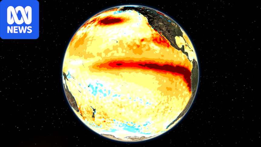
El Niño is strengthening across the Pacific Ocean at an alarming rate and could annihilate all previous records in the modern era.The rapid warming of our largest ocean is supplying additional heat into the Earth's atmosphere, contributing to a summer of extreme heatwaves and fires across Europe and North America.But with El Niño still months away from peaking, its impact on global weather will intensify through the back half of 2026, including in Australia, raising the prospect of our hottest spring on record and a heightened risk of drought and fires.Pacific heading to historic El Niño warmthEl Niño refers to a period of warmer-than-normal waters in the eastern and central Pacific Ocean along with the associated changes to the atmosphere, a state that can linger for up to 12 months.According to the Bureau of Meteorology (BOM), there have been 27 El Niño years since 1900, and both observations and forecasts indicate the 2026 El Niño is tracking into uncharted territory.El Niños are usually evaluated by the Niño 3.4 index, a simple measure of the water temperature compared to average in a box along the equator.A tongue of warm water along the equatorial Pacific is now deeply in El Niño territory and is affecting weather patterns across the globe. (ABC News)After starting the year at about -1 degrees Celsius, the index has soared to nearly +2C, easily the fastest developing El Niño since 1900, and even accounting for climate change, the signal from the Pacific is the strongest on record for late July.However, a typical El Niño does not peak until at least November, and leading global modelling, including the BOM's in-house model, are predicting further warming of the Niño 3.4 index to around +3.5C by mid-to-late spring.Considering the highest ever monthly Niño 3.4 figures are +2.6C from January 1983 and +2.65C from November 1902 (using the ERSST v5 database) , the 2026 El Niño, therefore, has the potential to not only hit +3C for the first time, but comfortably evolve into the strongest on record.Australia faces a scorching spring and summerSo why does a tongue of abnormal water temperature matter in the middle of the Pacific?Climatologist and meteorologists pay so much attention to El Niño because the shift in marine heat and currents leads to sweeping changes through the overlying atmosphereAustralia is especially vulnerable due to our proximity to the Pacific.Past events have contributed to some of our hottest and driest years on record.And while El Niño might not peak for another four to six months, its greatest impact on Australia is likely to be felt sooner.One of the most reliable markers of change in our region is the Southern Oscillation Index (SOI), a calculation of the pressure difference between Darwin and Tahiti.Its current value, shown in the graph below, has already dived to nearly -30, well beyond the El Niño threshold of -7, and the lowest in more than 40 years.A deeply negative SOI indicates high-pressure is dominating Australian longitudes while lower than normal pressure is established over the central Pacific.And since winds blow from high to low pressure, the typical easterly trade winds which bring tropical moisture to Australia from the Pacific have been reversed, so it is no surprise national rainfall has fallen off a cliff during the past few weeks.With this pattern now established for the remainder of the year, the prospects for a wet second half of 2026 are poor, and the latest BOM seasonal outlook from August to October heavily favours reduced rain across eastern states.The next three months are unlikely to bring significant rain to most of Australia as El Niño deepens. (ABC News)Another driver of Australia's weather variability may also prevent rain this spring, a positive Indian Ocean Dipole (IOD), which is basically the El Niño of the Indian Ocean is also showing signs of emerging.But while rainfall is likely to remain below average, our temperatures are almost guaranteed to stay well above normal.Modelling is tipping a mean national temperature in spring about 2C above the 1961 to 1990 baseline.This could make it Australia's hottest spring on record, challenging the current anomalies of +2.08C from 2024.The map below shows the chance of spring having temperatures in the top 20 per cent of years, and it is nearly a sure bet for the southern half of the country.The BOM's modelling is forecasting well-above-average temperatures for the coming months that could challenge records. (Supplied: BOM)While rainfall during El Niño years typically returns to average by January, the effect on temperatures lingers into the new year, and while it is still beyond the lead time of forecasts, at this stage the most likely outcome is a summer of extreme heat.But it is the combination of high temperatures and low rainfall, which is the greatest concern, since the two work together to dry out soils and enhance bushfires.One positive though, is unlike the lead up to Black Summer, most of the nation is not in the middle of a long and severe drought, so we should not automatically assume devastating bushfires will be widespread.How El Niño impacts global weatherEl Niño 's footprint extends well beyond the Pacific.The shift in marine heat and currents leads to sweeping changes through overlying pressure and wind patterns, which then has a downstream impact on both rainfall and temperatures as far afield as Africa and Europe.Average global sea surface temperatures have already reached record levels for more than a month, but the mass of oceanic warmth also acts like a heater, transferring immense amounts of thermal heat into the atmosphere.Thanks to the background influence of climate change, strong El Niño events therefore frequently send global air temperatures to record highs.It is no surprise the planet's hottest year, 2024, coincided with the back end of the last El Niño, but with this year's episode already stronger, global temperatures are on a trajectory which may even see 2027 nearing the 2C warming above pre-industrial levels for the first time.
Record-smashing El Niño to deliver Australia a spring of droughts and fires
Full Article
Original Source
Read the full article at Abc →KhanList aggregates and links to publicly available news content. We do not host full articles from third-party sources. Always verify important information with original sources.