
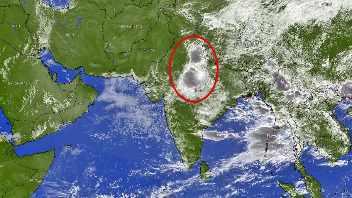
Satellite images show a major cloud build-up over Uttar Pradesh and nearby states as the monsoon stays active. Dry air over the northwest is limiting storm growth and creating a sharp rainfall divide.`Satellite imagery shows extensive cloud build-up across central and eastern India. (Photo: Windy)The southwest monsoon is set to remain significantly active over large parts of central, eastern and northern India over the next week, bringing spells of moderate to heavy rainfall to Uttar Pradesh, Madhya Pradesh, Bihar, Jharkhand, West Bengal, Uttarakhand and the northeastern states.Satellite imagery shows extensive cloud build-up across central and eastern India, while a contrasting weather pattern is emerging over the northwest and western parts of the country.Meanwhile, a massive intrusion of dry air is pushing across northwest India and extending into the Arabian Sea, limiting cloud formation and suppressing thunderstorm activity over several regions. According to the latest 48-hour rainfall outlook based on the AIFS weather model, Uttar Pradesh, Madhya Pradesh, Chhattisgarh, Bihar, Jharkhand, Odisha, Uttarakhand and Northeast India are likely to receive moderate to heavy showers.The active monsoon belt is expected to concentrate over these regions, supported by favourable moisture availability and atmospheric conditions that can trigger widespread cloud development and thunderstorms. For Uttar Pradesh and Madhya Pradesh, the coming days could bring repeated spells of rain, potentially improving seasonal rainfall figures in areas that have experienced uneven monsoon activity. Bihar, Jharkhand and West Bengal are also likely to remain under the influence of an active monsoon pattern, while Uttarakhand and the northeastern states could see frequent rainfall episodes.However, the picture is markedly different across northwest India.A large mass of dry air continues to spread across the region, affecting Rajasthan, Gujarat, Punjab, Haryana and Jammu and Kashmir, while also extending its influence towards Maharashtra and the adjoining Arabian Sea.This dry-air intrusion is particularly important because it is affecting the middle levels of the atmosphere, reducing the moisture needed for deep cloud formation. Even when surface temperatures and local conditions favour convection, dry air at higher levels can weaken developing thunderstorms or prevent them from growing into major rain-bearing systems.As a result, large parts of western and northwest India are expected to remain mostly dry, with only isolated or passing showers possible.The west coast, including parts of Maharashtra, Goa and Karnataka, may continue to receive occasional passing showers, but widespread and sustained monsoon rainfall is unlikely for now.The developing pattern highlights a sharp divide in India's monsoon. While central, eastern and northeastern states prepare for another active spell of rainfall, dry air is increasingly taking control over the northwest and parts of western India.For the next week, the focus of the monsoon will therefore remain firmly over UP, MP, Bihar, Jharkhand, West Bengal, Uttarakhand and Northeast India, while much of the rest of the country waits for a more favourable shift in atmospheric conditions.- EndsPublished By: Sibu Kumar TripathiPublished On: Aug 27, 2026 09:19 IST
Monsoon to stay active: Massive rain build-up seen over UP from space
Full Article
Original Source
Read the full article at Indiatoday →KhanList aggregates and links to publicly available news content. We do not host full articles from third-party sources. Always verify important information with original sources.