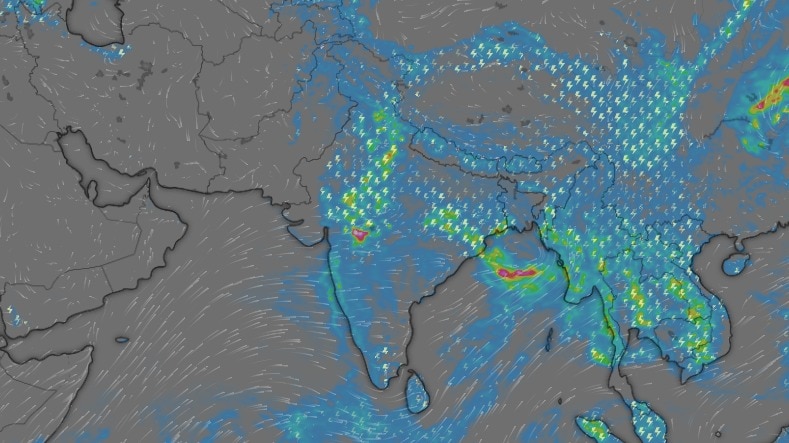
India's southwest monsoon has delivered an entirely uneven performance since its onset on June 4, with some states facing large rainfall deficits while others have received considerably more rain than normal.The latest India Meteorological Department (IMD) data for June 4 to August 10 shows India has received 465.9 mm of rain against a normal of 527.2 mm, leaving the country with a 12% deficit.The overall deficit exists, but it doesn't directly translate to the rains experienced across various states.In fact, different states have experienced different levels of rain, with some enjoying the monsoon, and some still yearning for it. (Source: IMD) WHICH INDIAN STATE IS THE DRIEST AND WHICH IS THE WETTEST?Meghalaya, also known as India's wettest state, has received the least amount of rainfall, with rain 56% below normal. The state received 763.1 mm against a normal of 1,739.6 mm during the period.Arunachal Pradesh and Manipur are also 36% below normal, while Bihar is 36% short. Other states like Punjab and Andhra Pradesh have recorded deficits of 35% each, while Goa is 35% below normal.On the other hand, Odisha has received 28% more rain than normal, with 857.8 mm against 668.7 mm, becoming the state with the highest excess rainfall so far until August 10. Two-wheeler riders commute during a sudden spell of heavy rain in Hyderabad. (Photo: PTI) Odisha's surplus has been helped by repeated low-pressure systems that have brought frequent bursts of heavy rain to the state.On August 8, a low-pressure area formed over south Gangetic West Bengal and adjoining north Odisha under the influence of an upper-air cyclonic circulation.The system then moved westwards, bringing moisture and the subsequent heavy rain over Odisha.But the other states have not been as fortunate as Odisha, with the monsoon remaining uneven and drenching only some regions.WHY HAS MONSOON BEEN SO UNEVEN?Monsoon rain is not distributed evenly throughout the season. People cover themselves as rain lashes the Taj Mahal during the monsoon. (Photo: PTI) Instead, its activity rises and falls as the monsoon trough shifts and low-pressure systems develop, often producing intense rain over one region while leaving another relatively dry.The recent pickup in the monsoon, which has brought a healthy rain spell in regions, including Delhi-NCR, is a good example.The IMD said a low-pressure area over northwest Madhya Pradesh and adjoining areas was driving rainfall activity, while another low-pressure system is expected to form over the north Bay of Bengal around August 12 and increase rainfall across parts of central and eastern India.CAN MONSOON DEFICIT BE RECOVERED?India's rainfall deficit has time to still narrow down, as the southwest monsoon officially runs until September 30. That leaves nearly seven weeks of the season after August 10. A satellite image shows the weather systems over the Indian subcontinent. (Photo: IMD) The IMD expects widespread rain over several parts of central, eastern, northeastern and northwest India through the coming days, with particularly active conditions over Odisha, Madhya Pradesh, Jharkhand, Bihar and parts of the Northeast.However, erasing the national deficit would require sustained and widespread rainfall, rather than a few intense spells.The uneven distribution also means that heavy rain in already-wet states such as Odisha cannot directly compensate for deficits in states such as Meghalaya or Bihar.For now, India's monsoon remains 12% below normal, but with nearly half of August and all of September still ahead, the final report card is far from written.- EndsPublished On: Aug 11, 2026 10:58 IST
Monsoon map reveals India's rain divide: Who got excess, who stayed dry?
Full Article
Original Source
Read the full article at Indiatoday →KhanList aggregates and links to publicly available news content. We do not host full articles from third-party sources. Always verify important information with original sources.