
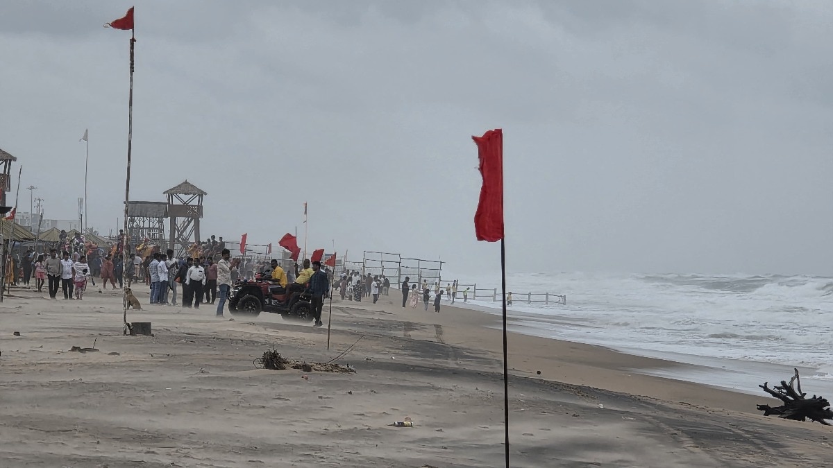
CYCLONE MURASU LIVECyclone Murasu Live Updates: Days after Cyclone Arnab wreaked havoc in Andhra Pradesh and Odisha, another cyclone called Murasu is being headed to the Andhra Pradesh coast again. It is expected to make landfall near Ongole in the intervening nights of Monday and Tuesday as a severe cyclonic storm. The impact of Murasu is expected to be felt across Andhra Pradesh, parts of Telangana, Tamil Nadu and Odisha. Schools have been declared shut in Chennai and Tiruvallur districts today ahead of the landfall. Odisha and Andhra Pradesh have expedited evacuation of people living in vulnerable zones to safe areas. The cyclone is expected to make landfall with wind speeds of up to 120 km/hour. A total of 11 flights arriving and departing from Chennai airport and 10 IndiGo flights from Gannavaram airport have been cancelled for today due to the cyclone. Follow indiatoday.in for live updates....Read MoreRed warning flags hoisted along the shoreline to restrict visitors from entering the sea as high tidal waves and rough weather prevail in Odisha's Puri. (Photo: PTI)Nov 2, 2026 16:15 ISTCyclone Murasu Tracking Live: Which states are on alert, will see rain ahead of landfall?The India Meteorological Department (IMD) has issued weather warnings for several states as Severe Cyclonic Storm Murasu approaches the Andhra Pradesh coast. Coastal Andhra Pradesh has been placed under a red alert for extremely heavy rainfall, while an orange alert has been issued for Rayalaseema, warning of very heavy rainfall. Tamil Nadu, Puducherry and Karaikal are also under an orange alert for very heavy rainfall. Telangana has been issued a similar warning, with heavy to very heavy showers expected in several areas. Chennai has declared a holiday for schools today in view of the forecast of heavy to very heavy rainfall. मौसम संबंधी चेतावनी ! मà¥à¤–à¥à¤¯ बिंदà¥: (i) पशà¥à¤šà¤¿à¤®-मधà¥à¤¯ बंगाल की खाड़ी के ऊपर बना गंà¤à¥€à¤° चकà¥à¤°à¤µà¤¾à¤¤à¥€ तूफान "मà¥à¤°à¤¾à¤¸à¥" (Murasu) उतà¥à¤¤à¤°-पशà¥à¤šà¤¿à¤® दिशा की ओर बढ़ने की पà¥à¤°à¤¬à¤² संà¤à¤¾à¤µà¤¨à¤¾ है। यह आज, 02 नवंबर की आधी रात (2330 बजे IST) से लेकर कल, 03 नवंबर 2026 की सबà¥à¤¹ (0400 बजे IST) के बीच, नेलà¥à¤²à¥‹à¤° और नरसापà¥à¤° के बीच (ओंगोल के दकà¥à¤·à¤¿à¤£ में) दकà¥à¤·à¤¿à¤£à¥€ आंधà¥à¤° पà¥à¤°à¤¦à¥‡à¤¶ के तट को पार करेगा। इस दौरान हवा की गति 100 से 110 किमी पà¥à¤°à¤¤à¤¿ घंटा होगी, जो à¤à¥‹à¤‚कों के साथ 120 किमी पà¥à¤°à¤¤à¤¿ घंटा तक पहà¥à¤‚च सकती है। (ii) इस पà¥à¤°à¤£à¤¾à¤²à¥€ के पà¥à¤°à¤à¤¾à¤µ के कारण, 02 और 03 नवंबर को तटीय आंधà¥à¤° पà¥à¤°à¤¦à¥‡à¤¶, रायलसीमा और तेलंगाना में; तथा 02 नवंबर को तमिलनाडॠमें à¤à¤¾à¤°à¥€ से बहà¥à¤¤ à¤à¤¾à¤°à¥€ बारिश होने की पà¥à¤°à¤¬à¤² संà¤à¤¾à¤µà¤¨à¤¾ है। इसके अलावा, 02 और 03 नवंबर को तटीय आंधà¥à¤° पà¥à¤°à¤¦à¥‡à¤¶, यनम और रायलसीमा में, तथा 03 नवंबर 2026 को तेलंगाना में कहीं-कहीं अतà¥à¤¯à¤§à¤¿à¤• à¤à¤¾à¤°à¥€ बारिश होने की à¤à¥€ संà¤à¤¾à¤µà¤¨à¤¾ है। Highlight: (i) Severe Cyclonic Storm “Murasu” over Westcentral Bay of Bengal is very likely to move northwestwards and cross south Andhra Pradesh coast as a Severe Cyclonic Storm with wind speed of 100 to 110 kmph gusting to 120 kmph between Nellore and Narsapur, to the south of Ongole during midnight (2330 Hrs IST) of today, the 02nd November to early hours (0400 Hrs IST) of tomorrow, the 3rd November, 2026. (ii) Under the influence of the above system, heavy to very heavy rainfall is very likely over Coastal Andhra Pradesh, Rayalaseema and Telangana on 02nd & 03rd; over Tamil Nadu on 02nd. Isolated extremely heavy rainfall is also likely over Coastal Andhra Pradesh & Yanam and Rayalaseema on 02nd & 03rd and over Telangana on 03rd November, 2026. South Peninsular India: â– Isolated to Scattered rainfall likely over Tamil Nadu, Puducherry & Karaikal during 2nd-8th November; Coastal Karnataka and Lakshadweep during 2nd-6th November; North Interior Karnataka during 2nd-3rd November and during 5th-8th November; Coastal Andhra Pradesh & Yanam, South Interior Karnataka and Telangana during 5th-8th November; Rayalaseema during 4th-8th November. â– Fairly Widespread to Widespread rainfall likely over Kerala & Mahe during 2nd-8th November; Coastal Karnataka and Lakshadweep during 7th-8th November; North Interior Karnataka on 4th November; Coastal Andhra Pradesh & Yanam, South Interior Karnataka and Telangana during 2nd-4th November; Rayalaseema during 2nd-3rd November. â– Isolated thunderstorm, lightning & gusty winds (speed reaching 80-90 kmph) likely over Coastal Andhra Pradesh & Yanam during 2nd-3rd November, with gusty winds (speed reaching 40-50 kmph gusting to 60 kmph) likely over Tamil Nadu, Puducherry & Karaikal during 2nd-4th November; Coastal Andhra Pradesh & Yanam and Rayalaseema on 4th November; Telangana on 2nd November, with gusty winds (speed reaching 30-40 kmph gusting to 50 kmph) likely over Kerala & Mahe and Lakshadweep during 2nd-6th November; Coastal Karnataka on 3rd November; North Interior Karnataka and South Interior Karnataka during 2nd-5th November. â– Isolated thunderstorm & lightning likely over Coastal Karnataka on 2nd November and during 4th-5th November. â– Isolated heavy rainfall likely over Tamil Nadu, Puducherry & Karaikal on 3rd November and during 5th-7th November; Kerala & Mahe during 2nd-4th November and during 7th-8th November; Coastal Karnataka and South Interior Karnataka during 2nd-5th November; Coastal Andhra Pradesh & Yanam, Rayalaseema and Telangana on 4th November with isolated very heavy rainfall also likely over Tamil Nadu, Puducherry & Karaikal and Telangana on 2nd November. â– Isolated extremely heavy rainfall likely over Coastal Andhra Pradesh & Yanam and Rayalaseema during 2nd3rd November; Telangana on 3rd November. â– Thundersquall (wind speed reaching 100-110 kmph gusting to 115 kmph) likely over Coastal Andhra Pradesh & Yanam on 02nd and 03rd November. â– Thundersquall (wind speed reaching 70-80 kmph gusting to 90 kmph) likely over Rayalaseema during 2nd-3rd November. â– Thundersquall (wind speed reaching 50-60 kmph gusting to 70 kmph) likely over Telangana on 3rd November. â– Strong Surface Winds likely over Coastal Andhra Pradesh & Yanam and Rayalaseema during 2nd-4th November. Central India: â– Isolated to Scattered rainfall likely over East Madhya Pradesh, Vidarbha and West Madhya Pradesh during 2nd-5th November; Chhattisgarh on 2nd November and during 5th-6th November. â– Fairly Widespread to Widespread rainfall likely over Chhattisgarh during 3rd-4th November. â– Isolated thunderstorm, lightning & gusty winds (speed reaching 40-50 kmph gusting to 60 kmph) likely over Chhattisgarh during 3rd-4th November, with gusty winds (speed reaching 30-40 kmph gusting to 50 kmph) likely over West Madhya Pradesh during 3rd-5th November; East Madhya Pradesh during 2nd-5th November; Vidarbha during 3rd-4th November. â– Isolated heavy rainfall likely over Chhattisgarh during 2nd-4th November. East India: â– Isolated to Scattered rainfall likely over Andaman & Nicobar Islands during 2nd-8th November; Gangetic West Bengal and Sub-Himalayan West Bengal & Sikkim during 2nd-3rd November; Jharkhand during 2nd-4th November; Bihar on 2nd November; Odisha during 5th-7th November. â– Fairly Widespread to Widespread rainfall likely over Odisha during 2nd-4th November. â– Isolated thunderstorm, lightning & gusty winds (speed reaching 40-50 kmph gusting to 60 kmph) likely over Odisha during 2nd-4th November. â– Isolated heavy rainfall likely over Odisha during 2nd-4th November. Northeast India: â– Isolated to Scattered rainfall likely over Arunachal Pradesh during 2nd-4th November and on 8th November; Assam & Meghalaya during 2nd-4th November and during 7th-8th November; Nagaland, Manipur, Mizoram & Tripura during 2nd-8th November. â– Isolated thunderstorm & lightning likely over Assam & Meghalaya and Nagaland, Manipur, Mizoram & Tripura on 2nd November. â– Isolated heavy rainfall likely over Arunachal Pradesh and Assam & Meghalaya on 2nd November. West India: â– Isolated to Scattered rainfall likely over Konkan & Goa, Madhya Maharashtra and Marathawada during 2nd5th November; Gujarat Region on 2nd November. â– Isolated thunderstorm, lightning & gusty winds (speed reaching 40-50 kmph gusting to 60 kmph) likely over Konkan & Goa and Madhya Maharashtra during 2nd-4th November. â– Isolated thunderstorm & lightning likely over Marathawada on 2nd November. â– Isolated heavy rainfall likely over Madhya Maharashtra on 2nd November. For more information, visit Us : https://t.co/BPpoTbykBF #CycloneMurasu #SevereCyclonicStorm #OdishaRain #CycloneAlert #RainfallForecast #IndiaWeather #HeavyRain #ThunderstormAlert #WeatherWarnings @moesgoi @airnewsalerts @DDNational @ndmaindia @ICRER_MHA — India Meteorological Department (@Indiametdept) November 2, 2026 Odisha, which is still recovering from the impact of Cyclone Arnab, is also likely to receive heavy to very heavy rainfall in its southern districts. The IMD has warned of further rainfall over the coming days, raising concerns about flooding and landslides in vulnerable areas. Heavy rainfall is also forecast in parts of Chhattisgarh, Kerala, Mahe and south interior Karnataka over the next two days. Meanwhile, fishermen have been advised not to venture into the southeast Bay of Bengal until Tuesday and the southwest Bay of Bengal until Wednesday morning. Nov 2, 2026 16:07 ISTCyclone Murasu Impact Live: 10 IndiGo flights from Vijayawada airport, 11 flights to and from Chennai cancelledAhead of Cyclone Murasu landfall, at least 10 IndiGo flights from Gannavaram airport in Vijayawada have been cancelled for today, reports our correspondent Apoorva Jayachandran. On the other hand, the Chennai airport, in a post on X, said 11 flights departing from and arriving at Chennai airport have been cancelled for today. #FlightUpdate | In view of the adverse weather conditions due to #CycloneMurasu, the following flights have been cancelled. Passengers are requested to contact the concerned airline for further information and assistance. #ChennaiAirport #Cyclone #Murasu #MurasuCyclone #CycloneUpdate #CycloneMurasuUpdate #FlightCancellations #Chennai #Airport #AAIAirports @MoCA_GoI | @AAI_Official | @IndiGo6E | @Pib_MoCA | @PIBChennai — Chennai (MAA) Airport (@aaichnairport) November 2, 2026 Nov 2, 2026 16:00 ISTCyclone Murasu Live: 3 NDRF teams from Chennai rushed to Andhra ahead of landfallThree teams of the National Disaster Response Force (NDRF), comprising a total of 90 personnel, have been deployed from the force's 4th Battalion near Arakkonam to neighbouring Andhra Pradesh as the state braces for Cyclone Murasu. Each specialised team consists of 30 personnel, an official said. The teams are being sent to vulnerable areas, including Nellore, Prakasam and Markapuram, to assist with rescue, evacuation and relief operations amid the approaching cyclone. (with inputs from PTI) Nov 2, 2026 15:57 ISTCyclone Murasu Landfall Update: Where is Cyclone Murasu right now?Cyclone Murasu is moving towards the Andhra Pradesh coast over the westcentral Bay of Bengal and is expected to make landfall between Nellore and Narsapur, south of Ongole, around midnight on Monday, the India Meteorological Department (IMD) said in its 2 pm bulletin. The severe cyclonic storm was moving west-northwestwards at a speed of 14 kmph over the past six hours. According to the IMD, the storm was located around 120 km east-southeast of Nellore, 140 km east-southeast of Kavali, 170 km northeast of Chennai, 180 km southeast of Ongole and 220 km south of Machilipatnam. Murasu is likely to continue moving northwestwards before crossing the south Andhra Pradesh coast as a severe cyclonic storm, packing sustained winds of 100-110 kmph and gusts of up to 120 kmph. The landfall is expected between 11:30 pm on Monday and 4 am on Tuesday. The Severe Cyclonic Storm “Murasu” [Pronunciation: Murasu]” over Westcentral Bay of Bengal moved west-northwestwards with a speed of 14 kmph during past 06 hours and lay centered at 1130 hours IST of today, the 02nd November, 2026 over the same region near Latitude 14.2°N and Longitude 81.1°E, about 120 km east-southeast of Nellore (Andhra Pradesh), 140 km east-southeast of Kavali (Andhra Pradesh), 170 km northeast of Chennai (Tamil Nadu), 180 km southeast of Ongole (Andhra Pradesh) and 220 km south of Machilipatnam (Andhra Pradesh). It is very likely to move northwestwards and cross south Andhra Pradesh coast as a Severe Cyclonic Storm with wind speed of 100 to 110 kmph gusting to 120 kmph between Nellore and Narsapur, to the south of Ongole during midnight (2330 Hrs IST) of today, the 02nd November to early hours (0400 Hrs IST) of tomorrow, the 3rd November, 2026. The Severe Cyclonic Storm “Murasu” is under the continuous surveillance of Doppler Weather Radars at Chennai,Machilipatnam and Visakhapatnam. — India Meteorological Department (@Indiametdept) November 2, 2026 Nov 2, 2026 15:53 ISTCyclone Murasu Latest Updates: After Arnab, Cyclone Murasu hurtles towards Andhra coastLess than a week after Cyclone Arnab battered Andhra Pradesh and Odisha, the two states are bracing for another cyclone even as relief and restoration efforts continue. Cyclone Murasu is expected to make landfall near Ongole late Monday night or early Tuesday, packing winds of 100-110 kmph and gusting up to 120 kmph. Andhra Pradesh has deployed disaster response teams and ordered evacuations from vulnerable areas. Odisha, meanwhile, is relocating residents from low-lying areas and landslide-prone hillsides. In neighbouring Tamil Nadu, Chennai has declared a holiday for schools today as heavy to very heavy rainfall is forecast. The approaching cyclone poses a fresh challenge to recovery efforts, with around 1.18 lakh people in Odisha still affected by floods and landslides triggered by Arnab, which made landfall on October 28. Forecasts of further rainfall in southern Odisha until November 4 have raised concerns over delayed restoration work, renewed flooding and landslides.
Live: Cyclone Murasu to hit Andhra coast after midnight; 21 flights cancelled
Full Article
Original Source
Read the full article at Indiatoday →KhanList aggregates and links to publicly available news content. We do not host full articles from third-party sources. Always verify important information with original sources.