
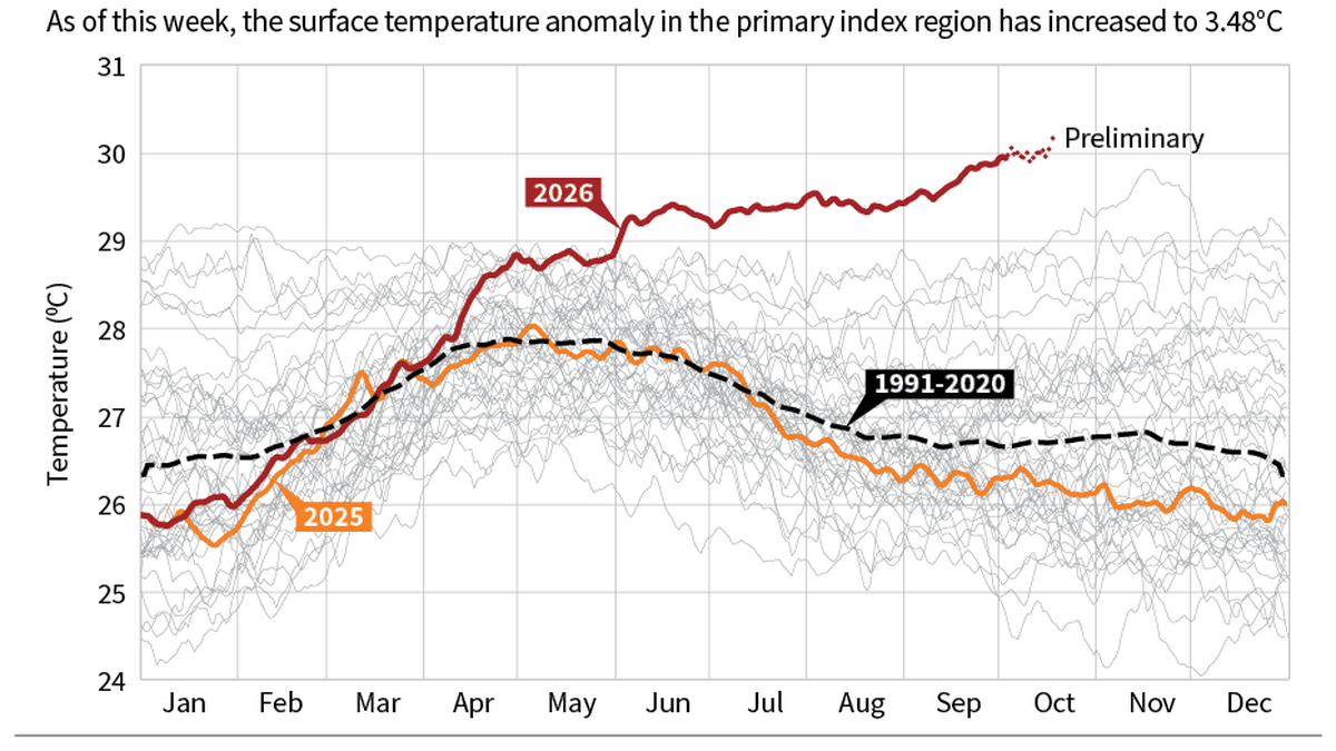
On October 5, the Niño 3.4 region recorded a sea surface temperature that exceeded 30° C for the first time in recorded history. | Photo Credit: ClimateReanalyzer.org For most of this year, climate scientists have been closely monitoring the Niño 3.4 region in the central-equatorial Pacific — the primary index area to define the phases of the El Niño Southern Oscillation and the alarming amount of ocean heat closely tracking an El Niño. The world’s oceans beyond the poles reached a record-high average surface temperature of 21.18°C on August 22, and daily sea surface temperatures in the Niño 3.4 region have been consistently shattering records.According to the U.S. NOAA’s Climate Prediction Center, a ‘strong to very strong’ El Niño is 83% likely, with a high chance of a historic event exceeding the strength of any previous El Niño since 1950.The El Niño is a natural climate pattern that emerges every two to seven years and affects global weather and heightens the risk of extreme heatwaves and altered rainfall worldwide. But this year’s event has put the world more on edge.“Even though there is no direct intensity-to-impact relationship, in general we expect stronger El Niño events will have stronger impacts,” Raghu Murtugudde, earth system scientist and emeritus professor at the University of Maryland and visiting professor at IIT Kanpur, said.The relationship between global warming and El Niño is not easy to tease out and remains an area of active research. A recent study analysing the geochemistry of corals in the last millennium at the Galapagos Islands, which lie in the ocean patch where the El Niño signal is strongest, found there has been a notable amplification of its intensity over the last 40 years.“Our analysis focuses less on individual events and more on the broader pattern of increasing strength of the El Niño system — which is much greater now than in the pre-industrial era,” said Julia Cole, professor of Earth and Environmental Sciences at the University of Michigan, who led the study, recently published in Science. “But the instrumental record of temperature is clear: this event is well outside the norm.”On October 5, the Niño 3.4 region recorded a sea surface temperature of 30.06°C: the first time in recorded history the region exceeded 30°C. The surface temperature anomaly in the region increased to 3.48° C on October 18 before dipping this week to 3.34°C.Meteorological agencies classify an El Niño’s strength based on the 90-day average of the temperature anomaly in Niño 3.4. Five consecutive months exceeding 0.5 °C signifies the onset of the warm El Niño phase. Strong events sport an anomaly of 1.5-1.9°C, and very strong ones an anomaly exceeding 2°C. Since the modern era of instrumental records began in the 1980s, there have been roughly a dozen significant El Niño events, with only three of these being very strong: 2015-16 (2.6°C), 1997-98 (2.4°C), 1982-83 (2.1°C).The ongoing 2026-27 El Niño onset was declared on June 6, and it is projected to peak in December with a seasonal anomaly of 3.8 °C.Scientists say no two El Niño events are the same and predicting their effects is not straightforward. However, the relationship between El Niño and global temperatures is quite straightforward: the release of stored ocean heat during these events causes global temperatures to temporarily spike in addition to global warming.“2027 will be warmer than 2026; that is how El Niño tends to work. It is also likely that 2027 will be the warmest so far, unless a massive La Niña appears and soaks up all the heat. So heat wave season is coming, that is a guarantee,” Dr. Murtugudde said.The relationship with the monsoon is less straightforward, however. While this year’s monsoon was 13% below normal, consistent with strong El Niños, severe drought did not materialise as feared. “This monsoon is not completely explained by El Niño,” per Dr. Murtugudde. “I think it has a very strong component of global warming.”The Central Water Commission’s latest weekly report shows that of 178 reservoirs around India, only 69% of the total storage capacity is filled. The south has the largest deficit, with only 44% storage filled.The 1982-83 El Niño was the first ‘super’ event in the modern era and it had devastating consequences for communities on almost every continent. It also triggered scientific enquiry into the phenomenon, leading to widespread improvements in monitoring and prediction. With improved understanding of El Niño mechanisms and advanced forecasting capabilities today, a clearer picture is emerging of how it will evolve over the coming months.Neelima Vallangi is an independent climate journalist.Image credit: ClimateReanalyzer.org Published - October 23, 2026 07:30 am IST
A ferocious El Niño is brewing thanks to record Pacific heat
Full Article
Original Source
Read the full article at Thehindu →KhanList aggregates and links to publicly available news content. We do not host full articles from third-party sources. Always verify important information with original sources.