
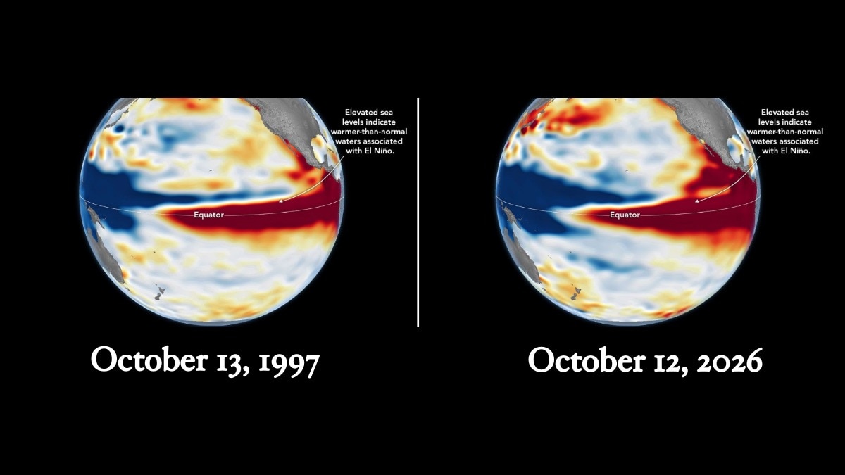
Nasa satellite observations show the 2026 El Nino increasingly resembling the powerful 1997 event. Scientists warn that regional weather impacts remain uncertain despite the striking ocean pattern.Sea levels are higher than normal across the central and eastern equatorial Pacific in October 2026 (right), a hallmark of El Niño. The pattern closely resembles October 1997 (left). (Photo: Nasa)New Delhi,Oct 23, 2026 12:41 ISTNasa has found that the developing 2026 El Nino is showing signs of rivaling the powerful 1997-98 event, one of the strongest on record, raising concerns about potentially severe weather disruptions across the world in the coming months.Satellite observations of sea surface heights across the equatorial Pacific suggest that the current event is developing a pattern similar to the 1997-98 El Nino, with unusually warm water extending eastward towards the coast of South America. Scientists say this could produce weather impacts resembling those seen during the earlier event, although the precise consequences remain uncertain.El Nino is a naturally occurring climate phenomenon that develops every two to seven years when waters in the central and eastern equatorial Pacific become warmer than usual. The warming disrupts atmospheric circulation, influencing rainfall, temperatures and storm patterns across the globe.The particularly strong El Nino events of 1997-98 and 2015-16 triggered widespread disruptions, including fires in Indonesia and the Amazon, drought-related crop failures in southern Africa, and heavy rainfall and coastal flooding in Southern California. According to Nasa, the 2026 event has developed more suddenly than the 1997-98 episode. However, the distribution of warm water across the Pacific now appears remarkably similar to that earlier event.“The search for the ‘typical’ El Nino is very elusive,” said Josh Willis, project scientist for sea level missions at Nasa’s Jet Propulsion Laboratory (JPL), noting that each event differs in how ocean warming develops and where its effects are felt.SATELLITES REVEAL THE DIFFERENCE Nasa scientists are using satellite altimetry, which measures the height of the ocean surface, to track the evolving phenomenon. As seawater warms, it expands, raising sea levels. Higher-than-normal sea surfaces across the central and eastern Pacific can therefore reveal the accumulation of heat associated with El Nino.Comparisons of satellite maps from October 1997, October 2015 and October 2026 show important differences between the events. In 1997 and 2026, elevated sea levels extend towards South America, while in 2015 the strongest anomalies remained farther offshore.These differences matter because the location of ocean warming influences how the atmosphere responds and where rainfall extremes develop.Nasa's 35-year satellite record allows scientists to compare current conditions with previous major El Nino events. “And right now, this one is on track to be even bigger,” Willis said, referring to the comparison with 1997. Graphic: Vani Gupta/India Today STRONG EL NINO LIKELY TO PERSIST INTO 2027The US National Oceanic and Atmospheric Administration's October 8 outlook gave an 83 per cent chance of a strong-to-very-strong El Nino continuing through the first three months of 2027.However, scientists caution that a similar ocean pattern does not guarantee identical weather outcomes. El Nino's influence travels through a complex atmosphere, and its effects can vary considerably between regions.The evolving event could influence winter rainfall, flooding and temperature patterns across several parts of the world. Its eventual impact will depend on how ocean warming develops and interacts with atmospheric conditions over the coming months.- Ends
Nasa's old satellite images reveal how 2026 El Nino is the strongest ever
Full Article
Original Source
Read the full article at Indiatoday →KhanList aggregates and links to publicly available news content. We do not host full articles from third-party sources. Always verify important information with original sources.