
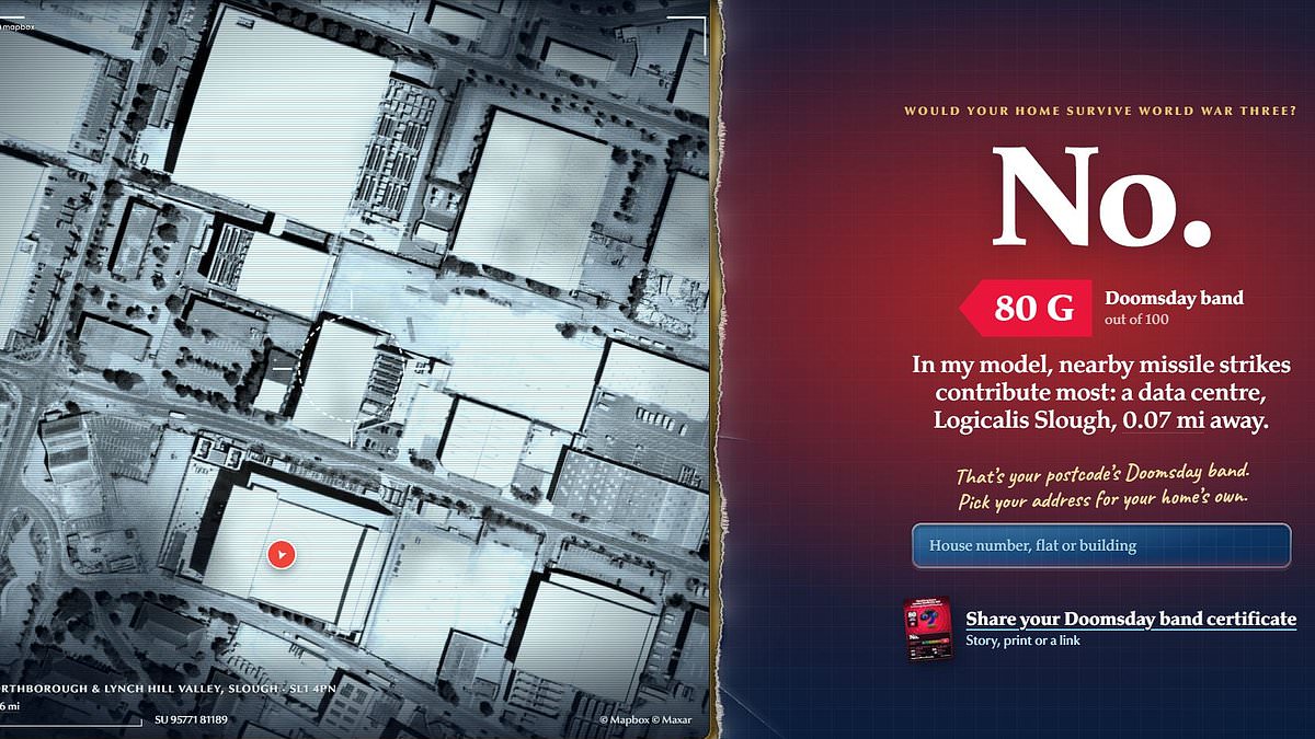
Would your house survive the apocalypse, or are you sitting in a potential doomsday death trap?A new interactive tool called Inspector Walls reveals just how safe your postcode would be if the missiles started to fall.The tool gives every home a score from A to G, ranging from the safest to the most at–risk locations.And the results will come as bad news to any city dwellers.The doomsday checker was created by Serhii Kashevko, 30, who came to the UK after war broke out in Ukraine.Speaking to the Daily Mail, Mr Kashevko explained that the most important factor affecting your home's safety is whether there are any military targets nearby and how close they are.However, the most at–risk homes in the UK aren't next to naval bases and airfields – but instead are on the Slough Trading Estate.Mr Kashevko explains that these homes are right next door to the UK's vital data centres, which would be a high–priority target for missile strikes in the event of war. A new interactive tool reveals just how safe your postcode would be if the missiles started to fall, with houses around the Slough Trading Estate proving to be the riskiest While you might expect homes near military bases to be more at risk, the close proximity of data centres makes living in Slough risky if war were to break out To find out how at risk your home is, all you need to do is enter your postcode into the search bar of the 'Would your home survive World War Three?' website, which you can try here.The tool then searches through publicly available records to work out the biggest sources of risk and whether your home has any natural protections.Mr Kashevko says: 'By far the biggest is what's near you: military bases, the Ministry of Defence, ports, power stations, even data centres, and how far away they are.'On the other hand, a nearby tube station or underground car park, which can serve as emergency bomb shelters, significantly reduces the risk score.Your home's location will also affect environmental risks like wind and rain, which can impact how far radioactive dust from potential nuclear strikes can travel.Thick walls and small windows – inferred from your home's energy rating – will also give a bonus to survivability.'And then there's afterwards: how cold your winters get, how far the nearest A&E is, whether there's more than one road out,' says Mr Kashevko.'A home with a fireplace, a hot–water tank and a gas hob copes with a blackout far better than a shiny new flat in a high–rise with none of them!' The tool gives every home a score from A to G, ranging from the safest to the most at–risk locations What determines whether your home will survive the apocalypse Nearby military targets Military basesMinistry of Defence buildingsPortsPower stationsData centresLocal safety featuresDeep underground tube stationsUnderground carparksA&E departmentsClimateWindRainNights below freezing per year With all these factors taken into account, the most at–risk areas are typically located in cities where there are lots of potential military targets.The Daily Mail's London office, for example, receives a somewhat alarming 'E' rating, summing up our survival odds as 'a coin toss'.Postcodes in Westminster fare even worse due to their proximity to the Ministry of Defence, giving one postcode an 'F' rating.On the other hand, Mr Kashevko says that the safest place in the country, by his estimation, is Fermanagh and Omagh in Northern Ireland, which is 'about as far as you can get from anything worth aiming at'.In Wales, the safest region is Gwynedd, while England's safest location is Thanet on the Kent coast.Scotland's safest location is Shetland, which is also home to the single safest postcode in the entire UK, scoring zero out of 100 for risk.The only drawback is that this lonely home on the island's west coast is so remote that the chances of receiving help in an emergency are near nil.Wales, meanwhile, is the safest country overall, with nearly half of all homes checked receiving an A or B rating, compared to one in six in England. The safest place in the country is Fermanagh and Omagh in Northern Ireland, which is 'about as far as you can get from anything worth aiming at' Since risk is largely determined by what is nearby, more rural areas generally score much better for safety In fact, Wales is so safe that Mr Kashevko says social media users have accused him of running a secret marketing campaign for the town of Bridgend.Overall, the most common risk ranking in Britain is 'D', and only one postcode in 3,000 gets the top ranking of 'G'.But if you do find that your home is in one of the most at–risk neighbourhoods, Mr Kashevko says there's no need to move out.Instead, he recommends making some basic preparations and planning to keep you and your family safe in case of an emergency.'Find the nearest place to get underground, a deep Tube station or an underground car park, and just do the walk once,' he says.'Maybe learn the way to your nearest A&E without your phone, have some necessities like long–lasting food, water and medicine stored that you'd use anyway.'This comes after the Government launched its 'Be Ready' campaign last month, urging families to stockpile supplies for a potential national disaster.Families were advised to keep three days of food and water on hand, alongside tools like torches and a wind–up radio. The most and least dangerous postcodes to be in during World War III Most DangerousLocation: SL1 4PN, Slough Trading Estate, SloughScore: 80GReason: Logicalis Slough data centre 0.07 miles awayLocation: SW1H 9BP, Westminster, LondonScore: 71FReason: MOD Main Building 0.4 miles away Location: W8 5HY, Kensington, London Score: 55EReason: MOD Main Building 2.9 miles away Location: L1 0AJ, LiverpoolScore: 35D Reason: Within Liverpool city centreLeast DangerousLocation: BT78 4PA, Fermanagh and Omagh, Northern IrelandScore: 3AReason: No nearby targetsLocation: ZE2 9BG, Shetland, ScotlandScore: 6AReason: No nearby targets Location: TN17 2AA, Cranbrook, Kent Score: 19BReason: Nearest target, Maidstone, 12 miles away
Would your house survive the apocalypse? Interactive tool reveals how your postcode would fare in a doomsday disaster
Full Article
Original Source
Read the full article at Dailymail →KhanList aggregates and links to publicly available news content. We do not host full articles from third-party sources. Always verify important information with original sources.