
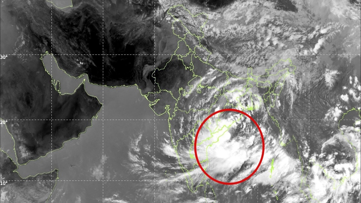
The IMD said the Bay of Bengal deep depression is set to cross the north Andhra Pradesh-South Odisha coast on Wednesday night. The focus remains on heavy rain, strong winds and rough seas rather than cyclone intensification.The system is expected to keep sea conditions dangerous. (Photo: IMD)The deep depression over the Bay of Bengal is unlikely to intensify into a cyclone before making landfall along the north Andhra Pradesh-South Odisha coast, with the India Meteorological Department (IMD) forecasting that the system will cross the coast as a Deep Depression on Wednesday night.The system was located over the westcentral and adjoining northwest Bay of Bengal at 8:30 am on September 23, 2026. It was centred around 60 km southeast of Kalingapatnam in Andhra Pradesh.The system has been moving westwards at about 5 kmph over the past six hours. According to the IMD, it is now expected to move west-northwestwards and cross the north Andhra Pradesh-South Odisha coasts between Visakhapatnam and Gopalpur, close to Kalingapatnam, by the night of September 23.This means the system is expected to retain its status as a deep depression rather than intensify into a cyclonic storm before landfall. The system is being continuously monitored by the Doppler Weather Radar at Visakhapatnam, which is tracking its movement and structure.HEAVY RAIN THREAT REMAINSAlthough the system is not currently forecast to become a cyclone, its impact could still be significant because of the heavy rainfall expected across Odisha and Andhra Pradesh. The IMD has forecast light to moderate rain at most places in Odisha, with heavy to very heavy rainfall at several locations and extremely heavy rainfall at isolated places over south Odisha on September 23 and 24. Heavy to very heavy rain could continue at isolated locations on September 25 and 26.Coastal Andhra Pradesh and Yanam are also expected to receive widespread rainfall, with heavy to very heavy rainfall at several places and extremely heavy rainfall on September 23 and 24. Heavy rain could continue at isolated locations on September 25.The system is also expected to keep sea conditions dangerous. Very rough seas are likely over the westcentral and northwest Bay of Bengal until the evening of September 24 before gradually improving.Rough to very rough conditions are also expected along and off the north Andhra Pradesh, Odisha and West Bengal coasts during this period.So, while the question of “Cyclone Arnab” may be drawing attention, the immediate concern is not the storm's name but its rainfall, winds and rough seas as the deep depression approaches the coast.- EndsPublished By: Sibu Kumar TripathiPublished On: Sep 23, 2026 13:30 IST
Will the deep depression in Bay of Bengal turn into Cyclone Arnab? IMD answers
Full Article
Original Source
Read the full article at Indiatoday →KhanList aggregates and links to publicly available news content. We do not host full articles from third-party sources. Always verify important information with original sources.