
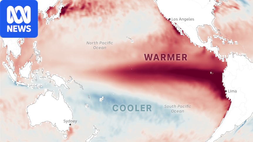
This El Niño is unlike those before it.(ABC News: Alex Lim)Climate scientists have been closely monitoring what is happening off Australia's east coast over recent months and are increasingly concerned by what they are seeing. Pacific Ocean temperatures, a key driver of El Niño, are rising at an extraordinary pace and starting to enter uncharted territory. Ocean temperatures are forecast to be 5 degrees above average in the central and eastern Pacific in December.(ABC News: Alex Lim)The dark, red tongue spreading in the Pacific is growing at a rate not seen in living memory. The El Niño brewing there is already breaking records, and it is months away from its peak. The sheer magnitude of the event and the uncertainty over what is driving it have alarmed experts.Among them is senior climatologist at the Bureau of Meteorology Felicity Gamble, who said the rate of warming over the past six months was the fastest ever recorded."We're actually seeing record values and record values by quite a significant margin as well," she said."So very warm ocean temperatures across much of the equatorial tropical Pacific."That does raise a lot of concern by meteorologists, oceanographers and marine scientists."Across the globe, anxiety over its backlash is growing, triggering a stark warning by the World Meteorological Organization (WMO)."El Niño in Spanish means boy child, but it has the potential to deliver a massive blow to communities and economies across the world. We are already seeing disruption and devastation," WMO secretary-general Celeste Saulo said.So far, the impacts of El Niño have been relatively mild in Australia. But in other parts of the world, the first ripples are being felt."From droughts and floods, we expect these impacts to increase as El Niño intensifies," Professor Saulo said."This exceptional El Niño demands exceptional preparation and response. Never before in the 50-year history of the World Meteorological Organization have we launched such a major mobilisation."Decades of research has deepened our understanding of how Pacific Ocean temperatures shape global weather, leaving countries better prepared than ever for potential impacts.But questions remain over how El Niño, and its cooler counterpart La Niña, will behave in a warming world. A boy reacts as smoke rises from wildfires in a residential area in Ogan Ilir, South Sumatra, Indonesia, on September 2.(Reuters: Abriansyah) A drone view shows wildfires burning in an area in Sungai Putri, West Kalimantan, Indonesia, on August 29.(Reuters: Willy Kurniawan) With Indonesia gripped by drought, fires are smouldering on the surface and underground.(Supplied: MODIS data from NASA)Fires linked to El Niño have blanketed Indonesia and Malaysia.1983 El Niño record looms largeIn autumn 1982, weather conditions across eastern Australia shifted dramatically and rainfall effectively ceased. The intense dry spell persisted for almost 12 months, with most of Victoria, southern New South Wales and parts of South Australia and Queensland experiencing record low rainfall.John McBride was a research scientist at the Bureau of Meteorology at the time and said the event, which triggered severe drought, the 1983 Melbourne dust storm and the Ash Wednesday bushfires, "came from nowhere"."In the lifetime of the active scientists working on atmosphere and ocean, we'd never seen anything like this," he said."The map of Australian rainfall over the 12 months was almost the lowest on record everywhere."Globally, there were these huge fires setting up across Borneo and Indonesia and there were major droughts and major flooding events in the Americas." John McBride lectures at a UNESCO workshop in 1982. (Supplied: John McBride) From April 1982 to February 1983 most of the country recorded significantly less rainfall than average.(ABC News: Alex Lim)Scientists did not know at the time that these conditions coincided with one of the strongest El Niño events in the modern era. El Niño and La Niña are the warm and cool phases of a natural climate pattern known as the El Niño Southern Oscillation (ENSO), which fluctuates every two to seven years.In the early 80s, ENSO was not well understood, and there was a widespread belief that it was not possible to forecast weather and climate conditions beyond one to two weeks, a consensus challenged by Dr McBride and his colleague Neville Nicholls. The pair published a scientific paper in February 1983 describing the relationship between ENSO and seasonal rainfall in Australia. The alternating trend of El Niño and La Niña with warmer or cooler waters prominent in the central/eastern Pacific.(ABC News: Alex Lim)It caused a stir among scientists around the world, given the climate conditions unfolding globally at the time, and the findings were pivotal in shaping the modern understanding of seasonal forecasting."No-one believed us when we were doing this work … they were saying, 'Maybe it's just statistics, it's just correlations, but there's no physical mechanism by which you can have forecasts on that time scale,'" Dr McBride said."The timing of our paper was fortuitous, I guess; we sort of went from people working on things that were wrong to heroes almost overnight." Two Forests Commission employees died when the bulldozer they were operating was overrun by a large blaze in Greendale, Victoria, in 1983.(Supplied: FFM Vic) During the 1982/83 El Niño, wind picked up the topsoil from bone-dry inland areas, creating a red-brown dust cloud rolling over Melbourne.(ABC News) The 1982 drought turned David Marsh's Boorowa farm into a desert.(ABC News: Olivia Ralph)The Melbourne dust storm and the Ash Wednesday fires fell into the El Niño event of 1982/83.This year's El Niño behaving differentlyIn the more than 40 years since Dr McBride and Professor Nicholls's paper, extensive research has built on their findings, leading to detailed seasonal forecasts that help inform decision-making for farmers and emergency services.Scientists have now identified regions within the Pacific Ocean, where they measure water temperatures to help determine which phase ENSO is in. If temperatures are significantly warmer than usual, an El Niño is likely, but colder than usual means it's likely a La Niña could develop.The key region is known as Niño3.4, and its associated relative index removes the warming trend due to climate change. That's important because otherwise it might seem like El Niño is happening more often.Models suggest the index will surpass 2.6 degrees Celsius this month, the January 1983 threshold.While it reached 2.65C in 1902, the reliability of the data improves as time goes on, so '83 can be considered the strongest in living memory. The forecast for this event is a staggering 3.6C, which would obliterate all previous records if it eventuates.El Niño and climate change 'load the dice'As the world continues to emit record amounts of fossil fuels, and temperatures rise, research has suggested the natural swings between La Niña and El Niño are becoming more frequent and intense due to climate change.While it is not entirely clear what is driving the intensity of this year's event, Monash University adjunct professor and climate councillor Andrew Watkins said warming global temperatures could be contributing."Climate change basically means that we're heating up the atmosphere, but about 90 per cent of that heat actually gets driven into the oceans," he said."The oceans are really what drives El Niño and its opposite, La Niña, and causes a lot of those changes to Australian climate."So we get that double impact of climate change warming our atmosphere, but also changing the strength of our El Niño and La Niña events."While our understanding of El Niño has grown substantially over the past four decades, predicting the exact behaviour of any single effect remains extremely difficult, given the interaction between oceans and the atmosphere is so complex.Importantly, a record event does not necessarily mean impacts on Australia will be severe or the same as they were during a previously intense El Niño. Several factors influence Australia's climate and weather, including other drivers like the Southern Annular Mode (SAM) and Indian Ocean Dipole (IOD). Local sea surface temperatures and natural weather variability also play a role, while climate change is increasingly having an impact."We have had some big El Niños in the past that haven't actually given us widespread drought," Dr Watkins said."But very strong El Niños events do load the dice for a drier spring and start of summer but also a hotter spring and summer, which can have large influences upon our fire weather."Unfortunately, we do see more coral bleaching at the end of summer during these big El Niño events."This year's event is already proving unique in its own right. The signal is very strong and, as expected, temperatures have been warmer than usual. But so far, there has been much more rainfall than what is typically seen during an El Niño year.The weather bureau's forecast for rainfall in spring shows below average across parts of southern and eastern Australia and above average across much of the country's west, while temperatures are expected to be warmer than usual across the board.Off the back of successive record-breaking heatwaves across the Northern Hemisphere, climate scientists are warning that next year could be another scorcher, as global temperatures continue to climb well after water temperatures in the Pacific Ocean peak.And it is not just the Pacific Ocean that is heating up, with the European climate service Copernicus declaring all the world's oceans reached their highest temperatures on record at the end of last month."Globally, the hottest years on record typically follow an El Niño event, as a lot of the heat in the ocean gets released into the atmosphere," Dr Watkins said."So lots of scientists are talking about 2027 almost being a dead cert for the globe's hottest year."World braces for impactNathaniel Johnson, a meteorologist at the National Oceanic and Atmospheric Administration (NOAA), said the world should leverage El Niño forecasts to prepare for its impacts."El Niño is one of our biggest sources of seasonal predictability," he said."We need to capitalise on this opportunity to understand the risks that are associated with El Niño and begin our preparations as early as possible." A villager carries a water container to collect spring water amid forecasts that El Niño may contribute to drier-than-normal conditions in Gunung Batur village, Indonesia.(Reuters: Ajeng Dinar Ulfiana) A man digs a hole in a dried-out riverbed and clears the water from it before taking a bath, in Galwela Yaya village, Sri Lanka, in August.(Reuters: REUTERS/Priyanshu Singh) Indonesian farmers prepare for the looming El Niño dry spell. (Reuters: Willy Kurniawan)Dr Johnson said El Niño was starting to play out as expected around the world."We've seen drought conditions throughout Central America, and that also tends to occur over parts of South America, parts of the Amazon Basin," he said."Also we've seen some enhanced rainfall in the southern parts of South America, particularly in southern Chile."They've been recording some atmospheric rivers and flooding rains, and that may be connected to the ongoing El Niño."UN secretary-general Antonio Guterres said the unprecedented nature of events was an urgent warning for stronger action to reduce emissions and protect people from the impacts of climate change."El Niño is being supersized before our eyes. The science leaves no room for doubt: the planet is in uncharted waters, and those waters are heating up," he said."The race now is between rising risks and our commitment to take climate action and protect people. We must win that race."Notes on the dataSea surface temperature (SST) maps source data from the Copernicus Climate Change Service via the European Centre for Medium Range Weather Forecasts. SST anomalies are calculated as the difference from 1993-2016 climatology.El Niño indices use the BOM's Relative Niño3.4 index.
Why this El Niño is different from all the others
Full Article
Original Source
Read the full article at Abc →KhanList aggregates and links to publicly available news content. We do not host full articles from third-party sources. Always verify important information with original sources.