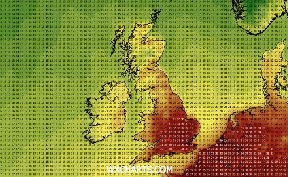
London could experience another heatwave in the coming days - but looks set to avoid the thunderstorms that could hit much of the country this week.Although temperatures are set to drop in the capital in the next few days, the BBC are forecasting highs of 30C next week.Weather forecasting site WXCharts latest maps suggest potential highs of 33 or 34C in the capital next Wednesday.Latest predictions show a 34C heatwave in London next week WX charts According to the Met Office, London will remain in the mid 20s early this week - close to the average for August following weeks of sweltering highs.Temperatures will then rise again through the weekend and into next week, with temporary builds of high pressure and southerly winds bringing the capital back above heatwave thresholds.An aerial view of Kensington Palace and Kensington Gardens in LondonPA WireThe threshold for heatwaves is different across the country, with a heatwave in London meaning three or more consecutive days during which temperatures reach 28C or higher.From Wednesday August 12 until Saturday August 15, the BBC is forecasting these marks to be exceeded, making it the sixth heatwave of a scorching summer.There will also be a return of “tropical nights”. WXCharts is predicting a particularly sticky night on Thursday August 13, with the mercury set to remain around 31C at midnight.A couple sit in the shade on a hot day in Greenwich ParkAFP/GettyMeanwhile, the capital seems set to avoid the large area of low pressure crossing the UK, which will bring areas of heavy rain, thunder and lightning to many parts of the country.Much of the north and west of the UK will be affected, with thunderstorms expected in parts later on Wednesday.The Met Office has issued a yellow warning for the northeast of Scotland between 10am and 9pm, warning of heavy, slow-moving showers and some thunderstorms.The storms could produce up to 50mm of rain in just three to six hours, leading to the possibility of localised flash flooding and impacts to transport networks.It is set to be windy across parts of Scotland, Northern Ireland, the Isle of Man and northern England on Wednesday, with gales possible on hills and coasts.Read MoreThe rain could head south by Thursday - but forecasters are predicting that the weather will turn more showery.Some of the rain may reach parched areas in the east of England, but little is expected for central and southern England.Tourists pose for a selfie on Westminster Bridge during the fourth summer heatwaveGettyIt comes after following a boiling June and July, with weather related records falling day after day.And another record was set on Tuesday, as the UK registered its 34th day of temperatures reaching 30C or higher in a calendar year, equalling the record set in 1995.Provisional statistics showed that only 5.6mm of rainfall was recorded in England in July - less than half of the previous record of 13.4mm set in 1911.
When will the next heatwave be? Scorching 34C temperatures to return as London avoids thunderstorms
Full Article
Original Source
Read the full article at Standard →KhanList aggregates and links to publicly available news content. We do not host full articles from third-party sources. Always verify important information with original sources.