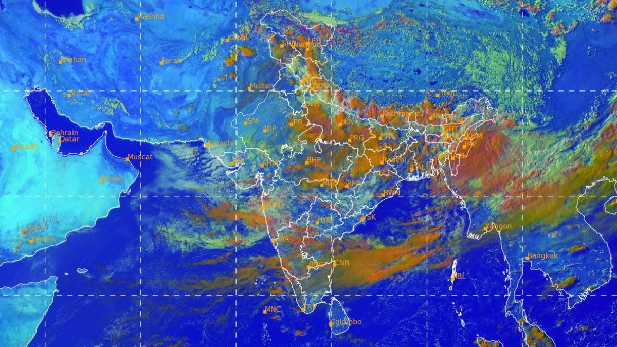
A fresh western disturbance is due to sweep into Jammu and Kashmir from July 21, arriving just as the monsoon trough pushes north from the Arabian Sea and the Bay of Bengal.Where the two systems meet, over the Pir Panjal and Dhauladhar ranges, they are expected to trigger one of the season’s most dangerous rain spells across Jammu and Kashmir, Himachal Pradesh and Uttarakhand.Meteorologists are tracking very heavy to extremely heavy rainfall, with single-event totals crossing 250mm in places.The peak window falls between July 21 and July 23, and authorities are already advising residents to stay alert and travellers to avoid the region through the week. HOW IS THIS RAIN SPELL DIFFERENT FROM ORDINARY SHOWERS?Two weather systems are converging over the mountains at once. The monsoon trough, the low-pressure channel carrying moisture-laden winds from the Arabian Sea and the Bay of Bengal, is pushing north. Bands of moisture-laden monsoon clouds stream across the Arabian Sea towards the west coast, feeding rainfall over peninsular India. Deep convective clouds, shown in red and orange, cluster over eastern and northeastern India while the Bay of Bengal stays relatively quiet. (Photo: IMD) Meeting it is a western disturbance, a storm system that usually visits India in winter, riding in on the westerly jet stream. When these two overlap above the Himalayas, they feed each other, turning ordinary monsoon rain into something far more intense.WHAT HAPPENS WHEN THIS MOISTURE HITS THE MOUNTAINS? The Himalayas do not let moist air pass easily. Forced upward by the steep slopes, the air cools rapidly and its water vapour condenses into clouds faster than it would over flat land, a process called orographic lifting. Floodwater rushes through Jammu and Kashmir after a burst of intense rainfall. (Photo: PTI) Narrow valleys then trap the resulting storms in place instead of letting them drift away, so the same hillside can be soaked for hours at a stretch.WHY DOES 250MM OF RAIN MATTER SO MUCH?The India Meteorological Department classifies a single day total of 250mm or more as extremely heavy rainfall. That works out to 250 litres of water landing on every square metre of ground within 24 hours.On a mountainside with thin soil and fractured rock, that volume does not soak in. It runs, and it runs fast.WHAT EXACTLY IS A CLOUDBURST?A cloudburst is not simply heavy rain. It happens when strong upward air currents hold huge quantities of water suspended inside a cloud, until the cloud can no longer support the weight. The INSAT-3DR infrared image for July 19 marks the coldest, tallest storm clouds with red and purple contours over Jammu and Kashmir, the Gangetic plains and the Northeast. (Photo: IMD) The water then falls all at once, often more than 100mm in a single hour, over an area as small as 20 to 30 square kilometres, triggering flash floods and landslides with almost no warning.WHY DO SLOPES COLLAPSE AFTER DAYS OF RAIN?Rain adds weight to loose soil and rock, and it seeps into the tiny gaps between soil particles, building up pressure that reduces the friction holding a slope together.Once that pressure crosses a threshold, gravity wins and the hillside gives way, sometimes as a slow slide and sometimes as a sudden rush of mud and rock.IS CLIMATE CHANGE MAKING THIS WORSE?A warmer atmosphere holds roughly seven per cent more moisture for every degree Celsius of warming, a relationship physicists call the Clausius-Clapeyron equation.The Arabian Sea is warming rapidly, and that extra moisture is why scientists are watching short, intense downpours over the western Himalayas grow more frequent. A flash flood-damaged mountain road in Jammu and Kashmir after prolonged monsoon rain. (Photo: PTI) Authorities have flagged high landslide risk on multiple mountain routes and possible cloudbursts and flash floods at isolated places through the week.Residents are advised to stay alert, and travellers are being told to avoid non-essential trips to Jammu and Kashmir, Himachal Pradesh and Uttarakhand until the spell passes.- EndsPublished By: Radifah KabirPublished On: Jul 19, 2026 17:03 IST
Western Himalayas face dangerous rain spell next week. Know states under alert
Full Article
📰 Original Source
Read full article at Indiatoday →KhanList aggregates and links to publicly available news content. We do not host full articles from third-party sources. Always verify important information with original sources.