
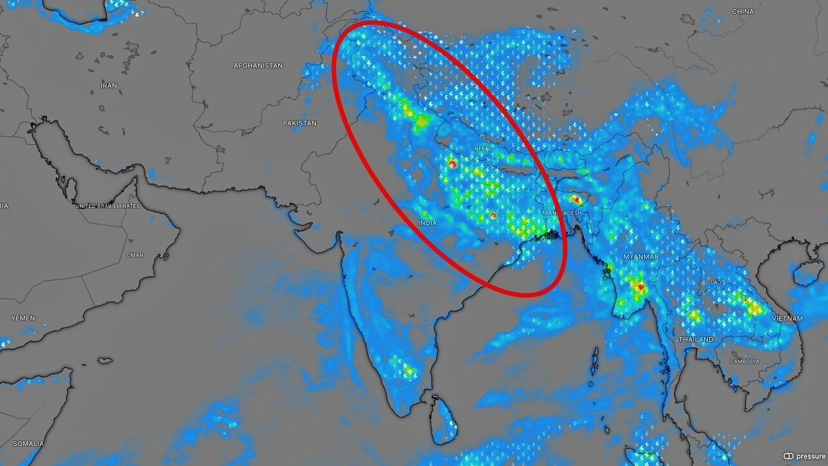
A Western Disturbance is set to interact with the monsoon axis over north India this week. The system could intensify rain across the hills and plains, offering some relief to deficit-hit Punjab and Haryana.The upcoming system could be particularly important for Punjab and Haryana. (Photo: Windy)September has begun with the first signs of a changing weather pattern across northern India, as a Western Disturbance is expected to emerge as a major driver of monsoon rainfall in the coming days.The first significant interaction between a Western Disturbance and the active monsoon axis, along with a low-pressure area, is expected to unfold over north India between September 4 and 7.The interaction could trigger a widespread and potentially intense spell of rainfall across the Himalayan states and adjoining plains.Jammu and Kashmir, Himachal Pradesh and Uttarakhand are likely to be among the worst-affected regions. Very heavy to extremely heavy rainfall is possible over parts of these states for the rest of the week, with the weather system expected to become more aggressive between September 4 and 6. The plains of north India could also see a major revival of monsoon activity. Scattered moderate to heavy rain is expected to begin over parts of western Uttar Pradesh, Delhi-NCR, eastern Haryana, Chandigarh and eastern Punjab on September 3 and 4. Initially, however, the rainfall is expected to remain relatively patchy and low in coverage, driven mainly by the monsoon axis and easterly winds.The weather situation could change significantly as the Western Disturbance begins interacting with the low-level monsoon trough.This interaction is expected to increase rainfall coverage and intensity, potentially bringing widespread heavy rain to Punjab, Haryana and Delhi-NCR. Parts of northern and eastern Rajasthan could also experience significant rainfall during the spell.The upcoming system could be particularly important for Punjab and Haryana, where the monsoon has remained deficient. Rainfall in Punjab currently stands around 33 per cent below normal, while Haryana is facing a deficit of approximately 22 per cent.A widespread spell of rain between September 4 and 5 could therefore help reduce some of the seasonal rainfall shortfall across the two states.The broader monsoon picture remains challenging across India. Pan-India rainfall departure stood at around 13.6 per cent below normal until September 1, reflecting uneven rainfall distribution during the season.The entire southern peninsula has experienced deficient rainfall, while Punjab, Haryana and Rajasthan in northwest India have also struggled. Significant rainfall deficits are also being reported across parts of far eastern and northeastern India, including Bihar, Arunachal Pradesh, Assam, Meghalaya and Manipur.For much of the rest of the week, southern and northeastern India are unlikely to receive enough widespread rainfall to significantly recover their large seasonal deficits.The focus, instead, is shifting towards northern India.With scattered showers expected to begin from September 3, followed by the possibility of widespread heavy rain during September 4 and 5, Punjab and Haryana could see some much-needed recovery.As September progresses, Western Disturbances are likely to become increasingly important weather drivers across north India. The first major interaction of the month could now set the tone for a renewed and potentially intense phase of monsoon rainfall across the region.- EndsPublished By: Sibu Kumar TripathiPublished On: Sep 2, 2026 07:00 IST
Western disturbance to drive monsoon rain in September, first signs visible
Full Article
Original Source
Read the full article at Indiatoday →KhanList aggregates and links to publicly available news content. We do not host full articles from third-party sources. Always verify important information with original sources.