
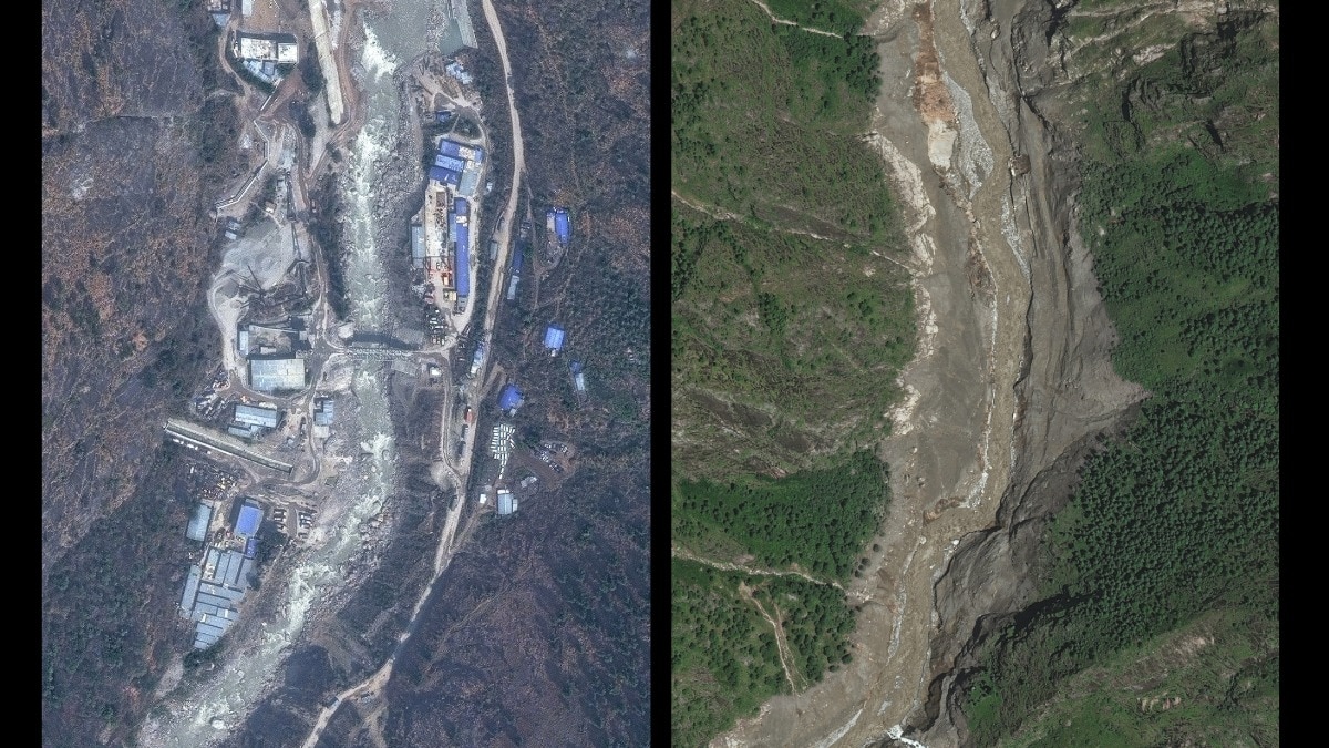
Analysis of pre-and-post satellite images reveal bridges swept away, hydropower plants crippled and homes erased along Nepal's Trishuli corridor.Satellite image 2026 VantorImages of the Rasuwagadhi immigration office being swept away have come to define Nepal’s flood disaster. But the wrecked building was only one glimpse of the havoc left behind.No tally of shattered roads, bridges and public infrastructure can capture the human loss. But the wreckage lays bare the sheer scale of destruction. Planet labs PBC/ India Today Nepal’s preliminary assessment puts infrastructure damage at "around Rs 200 billion", while Roads Department chief Bijaya Jaishi estimated damage to roads and bridges alone at "more than Rs 15 billion".India Today Open Source Intelligence (OSINT) team independently analysed pre- and post-flood satellite imagery from commercial satellite firms Vantor and Planet Labs PBC, and reviewed official records to assess critical damage along the river corridor.BRIDGES: 16 CROSSINGS INDEPENDENTLY ASSESSED The analysis identified visible damage at 16 bridge crossings across the Bhote Koshi Trishuli corridor, including sites around Syabrubesi, Bidur and Betrawati Bazaar. Planet Labs PBC/ India Today Three crossings around Syabrubesi were assessed as wiped out. Eight around Bidur and two at Betrawati Bazaar showed visible damage. Planet Labs PBC & Satellite image 2026 Vantor/India Today Three additional crossings were assessed separately, with one partly submerged and two likely washed away in the available imagery. Planet labs PBC/India Today The Roads Department puts the wider toll higher. Director Bijaya Jaishi said, “41 bridges and about 42 kilometres of roads had been damaged.”HYDROPOWER BELT TAKE THE HIT The same river system carries some of Nepal’s most important hydropower infrastructure. Satellite image 2026 Vantor/India Today Our mapping located seven major facilities along the affected corridor, including Rasuwagadhi, Sanjen Khola, Langtang Khola, Upper Mailung, Upper Trishuli 3A, Trishuli and Devighat.At the 111 MW Rasuwagadhi project, before and after satellite imagery shows large parts of the plant complex and adjoining structures replaced by a broad debris and flood scar. At least 11 hydropower projects and one solar plant has been damaged Nepal Electricity Authority spokesperson Rajan Dhakal said, "The flood has affected a total of 11 hydropower projects and one solar plant."The affected projects together removed "431.1 MW from Nepal’s national grid."The list includes Rasuwagadhi, Sanjen facilities, Langtang Khola, Upper Trishuli 3A, Upper Mailung, Mailung, Trishuli and Devighat.SYABRUBESI: HOMES VANISH FROM THE RIVERBANK Satellite image 2026 Vantor/India Today The destruction extends beyond roads and power plants. India Today’s analysis of satellite imagery mapped 192 structures along the Syabrubesi riverbank, of which 114 appear damaged or swept away, while 78 remained visible.Post-flood imagery shows the river and debris field expanding across areas previously occupied by homes, erasing entire clusters along the embankment.AND THE DANGER HAS NOT ENTIRELY PASSED China’s Ministry of Water Resources warned that a newly formed barrier lake upstream was "posing a high risk of a breach."Researcher Zhu Jinfeng told CCTV, "The volume of water is continuing to increase, and so is the risk."- EndsPublished On: Aug 28, 2026 17:55 IST
We looked at 30+ satellite images. This is what Nepal's trail of havoc looks like
Full Article
Original Source
Read the full article at Indiatoday →KhanList aggregates and links to publicly available news content. We do not host full articles from third-party sources. Always verify important information with original sources.