
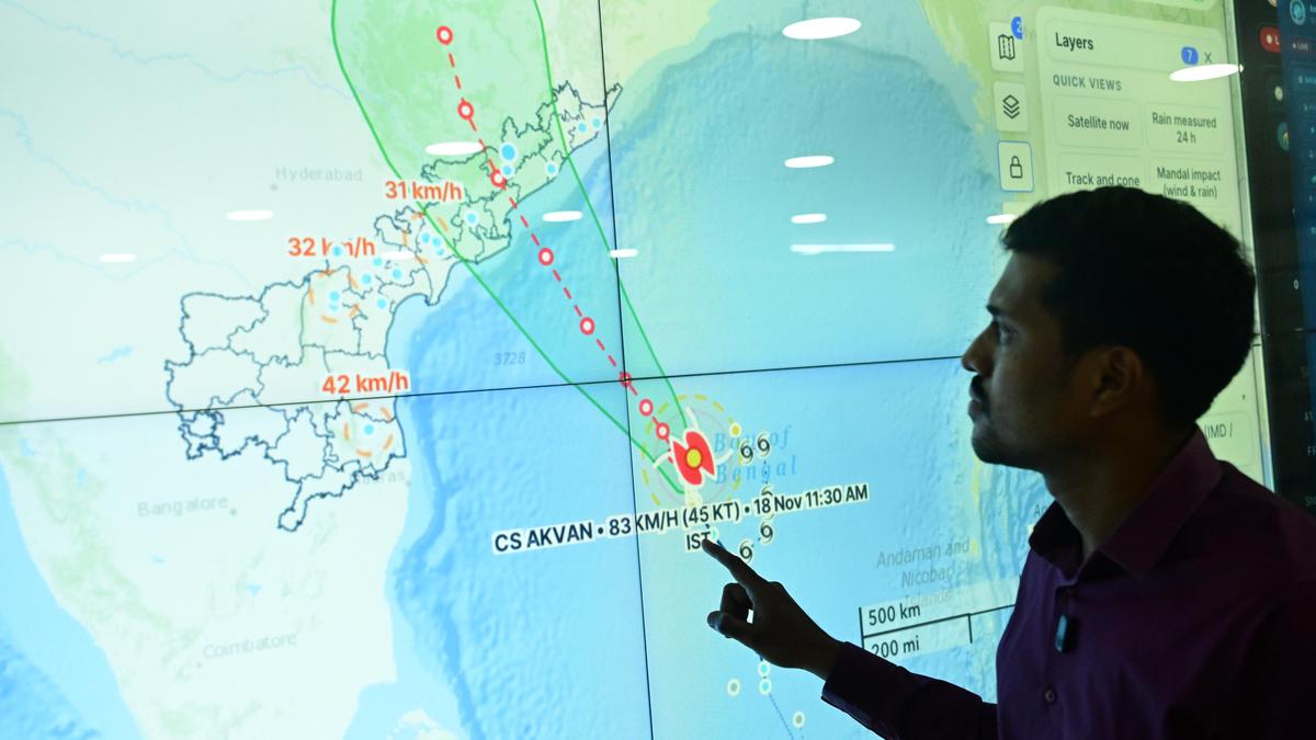
A meteorologist explaining the movement of Cyclone Akvan over the Bay of Bengal and its probable track and landfall locations at the Andhra Pradesh State Disaster Management Authority office at Tadepalli in Guntur district on Wednesday. | Photo Credit: G.N. RAO The projected trajectory of the Severe Cyclonic Storm (SCS) Akvan kept changing its path on Wednesday. And, due to the uncertainty over the movement of the system, the northern parts of Andhra Pradesh and southern parts of Odisha have now been placed on alert.While the initial forecast of the India Meteorological Department (IMD) showed that the system may move towards Machilipatnam, or Bapatla of Central Andhra Pradesh as a Very Severe Cyclonic Storm (VSCS), a revised forecast said Akvan may not intensify into a VSCS, and its trajectory also changed later to Narsapur-Kakinada, and then further north towards North Andhra and South Odisha.The 8 p.m. bulletin says the landfall could be between Narsapur of Andhra Pradesh and Puri of Odisha on November 20, as a Severe Cyclonic Storm with wind speed of around 120 kmph, but weather experts say there is a possibility of the system weakening further before the landfall.The uncertainty has been attributed to multiple factors, including El Nino, lack of distribution of ocean heat content and mid-level moisture, among others. Explaining, P.L.N. Murty, Head of the Cyclone Warning Centre, Visakhapatnam, says that the Bay of Bengal had already seen two back-to-back systems, Arnab and Murasu, which left insufficient moisture for a third.One of the main factors for the development of a tropical cyclone is mid-level moisture. “If there is not sufficient moisture, the cyclone may not form,” he explained.“As the system began moving further north, towards North Coastal A.P. and Odisha, the system has met with cold sea waters, which may cause the system to weaken before the landfall,” Mr. Murty said. Severe beach erosion caused by powerful waves and sea surge along the shoreline at R.K. Beach in Visakhapatnam on Wednesday, as Cyclone Akvan approaches the Andhra Pradesh coast. | Photo Credit: K.R. DEEPAK He added that Akvan would be a new case study for the experts, especially during an El Nino year. “While forecasting a cyclone and its intensity, we usually depend on about nine numerical models as part of the consensus-based forecast. But this time, there was a lot of divergence among models,” he said.Red alert for six A.P. districtsWith the trajectory shifting from Central A.P. to North Coastal A.P., the IMD issued a new bulletin with fresh rainfall alerts, and this time, for the districts of Srikakulam, Vizianagaram, Visakhapatnam, Alluri Sitharama Raju (ASR), Anakapalli and Kakinada, and southern part of Odisha.All these districts have been put on red alert, as isolated extremely heavy rainfall is expected on November 19 and 20. An orange alert has been issued for the districts of Parvathipuram-Manyam, Dr. B.R. Ambedkar Konaseema, East Godavari and West Godavari.Even as uncertainty continues, the Andhra Pradesh government has deployed three NDRF teams in Srikakulam, Tekkali and Palasa, two at Salur and Seethampeta of Parvathipuram-Manyam district and one SDRF team in Vizianagaram.At 5.30 p.m., the storm was located over westcentral and central parts of South Bay of Bengal, about 500 km southeast of Narsapur and 540 km south-southeast of Kalingapatnam of Andhra Pradesh, 560 km East of Chennai of Tamil Nadu, 630 km South of Gopalpur of Odisha and 690 km South of Puri of Odisha.While there was a heavy rainfall alert for North Coastal A.P. on Wednesday, the State did not witness any rainfall activity till 8 p.m. Published - November 18, 2026 09:36 pm IST
Uncertainty over path of Cyclone Akvan; North A.P. and South Odisha put on alert now
Full Article
Original Source
Read the full article at Thehindu →KhanList aggregates and links to publicly available news content. We do not host full articles from third-party sources. Always verify important information with original sources.