
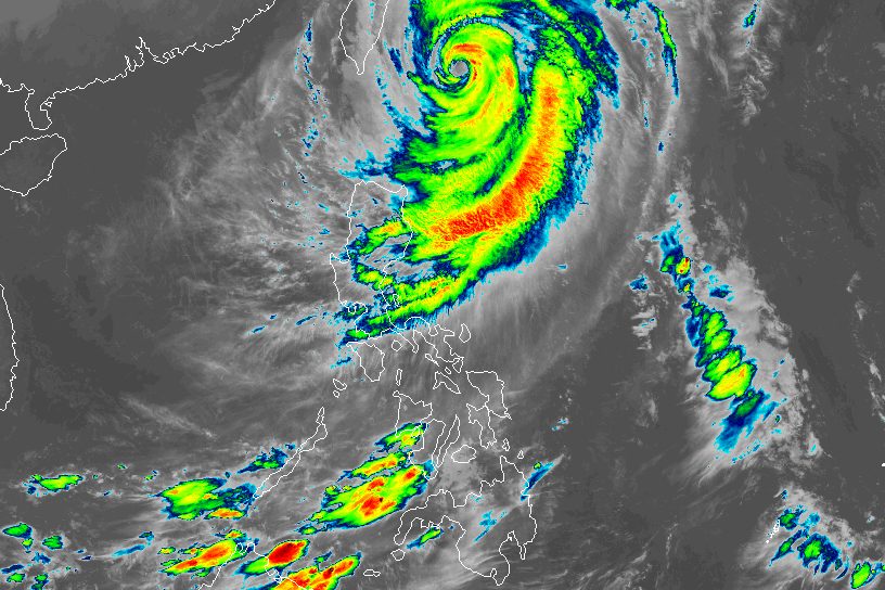
ROSAL. Satellite image of Typhoon Rosal (Champi) as of October 23, 2026, 4 am. JMA Typhoon Rosal (Champi) is last spotted 275 kilometers east northeast of Itbayat, Batanes, at 4 am on Friday, October 23 Typhoon Rosal (Champi) is still affecting Batanes and other parts of Northern Luzon on Friday, October 23. Rosal is projected to exit the Philippine Area of Responsibility by Saturday, October 24. This is AI-generated. Read the article for full context. Report any errors. MANILA, Philippines – Typhoon Rosal (Champi) continued to affect Batanes and other parts of Northern Luzon on Friday, October 23, even though it has spared the Philippines from landfall. Rosal was last spotted 275 kilometers east northeast of Itbayat, Batanes, as of 4 am on Friday. The typhoon is moving northwest at only 15 kilometers per hour (km/h). Its maximum sustained winds had weakened to 155 km/h on Thursday evening, October 22, while its gustiness eased to 190 km/h. At its peak, Rosal was a super typhoon with maximum sustained winds of 215 km/h. The Philippine Atmospheric, Geophysical, and Astronomical Services Administration (PAGASA) said in a bulletin issued at 5 am on Friday that Rosal is still bringing moderate to heavy rain (50-100 millimeters) to Batanes in the coming hours. Ilocos Norte, Apayao, Cagayan, and Isabela may also continue to experience rain with gusty winds due to Rosal on Friday, while the rest of the Cordillera Administrative Region, the rest of Cagayan Valley, Ilocos Sur, La Union, and Aurora are likely to see scattered rain and thunderstorms caused by the typhoon. PAGASA added that Rosal’s trough or extension is affecting Masbate, Palawan, the Visayas, Zamboanga Peninsula, Lanao del Norte, Misamis Occidental, Basilan, and Tawi-Tawi. These areas could have scattered rain and thunderstorms as well. Tropical cyclone wind signals also remain in effect in the following areas as of 5 am on Friday: Signal No. 2 Gale-force winds (62 to 88 km/h), minor to moderate threat to life and property Batanes northeastern part of Babuyan Islands (Babuyan Island, Panuitan Island, Calayan Island, Camiguin Island) Signal No. 1 Strong winds (39 to 61 km/h), minimal to minor threat to life and property rest of Babuyan Islands mainland Cagayan northeastern part of Isabela (Maconacon, Divilacan, Santa Maria, Cabagan, San Pablo, Palanan) Ilocos Norte Apayao PAGASA no longer sees Signal No. 3 as a possibility. The northeasterly windflow and the periphery or outer bands of the typhoon will also bring strong to gale-force gusts to these areas: Friday, October 23 most of Luzon and Visayas, Zamboanga del Norte, Misamis Occidental, Lanao del Norte, Camiguin, Davao Occidental, Davao Oriental Saturday, October 24 Batanes, Babuyan Islands, Ilocos Norte, Polillo Islands, Bicol, Romblon, Capiz, Iloilo, Negros Occidental Sunday, October 25 Batanes, Babuyan Islands Warnings for seaboards affected by Rosal have yet to be lifted. These are the updated coastal conditions for Friday: Up to very rough, high, or very high seas (travel is risky for all vessels) Northern and eastern seaboards of Batanes – waves up to 12 meters high Remaining seaboards of Batanes – waves up to 9 meters high Northern and eastern seaboards of Babuyan Islands; northeastern seaboard of mainland Cagayan – waves up to 8 meters high Remaining seaboards of Babuyan Islands and mainland Cagayan; seaboard of northern Isabela; northern seaboard of Ilocos Norte – waves up to 6 meters high Remaining seaboard of Isabela – waves up to 5.5 meters high Remaining seaboard of Ilocos Norte – waves up to 5 meters high Seaboards of northern Ilocos Sur and northern Aurora; northern seaboards of Camarines Sur and Camarines Norte; northern and eastern seaboards of Polillo Islands and Catanduanes – waves up to 4.5 meters high Up to rough seas (small vessels should not venture out to sea) Seaboard of northern La Union; remaining seaboards of Aurora and Ilocos Sur; eastern seaboard of Northern Samar; northeastern seaboard of Eastern Samar; western seaboard of Pangasinan – waves up to 4 meters high Eastern seaboards of Albay and Sorsogon; northern seaboard of Northern Samar; remaining eastern seaboard of Eastern Samar – waves up to 3.5 meters high Seaboard of Zambales; eastern seaboards of Dinagat Islands and Siargao-Bucas Grande Islands – waves up to 3 meters high Up to moderate to rough seas (small vessels should take precautionary measures or avoid sailing, if possible) Western seaboards of Bataan and Lubang Islands; seaboard of Surigao del Sur; remaining seaboards of La Union, Pangasinan, and Catanduanes; northern seaboard of Kalayaan Islands – waves up to 2.5 meters high Western seaboards of Batangas, Cavite, Occidental Mindoro, and Palawan including Calamian Islands; eastern seaboard of Davao Oriental; remaining seaboards of Lubang and Kalayaan Islands – waves up to 2 meters high ALSO ON RAPPLER Rappler Recap: Race for next chief justice begins with Leonen, Caguioa Bangko Sentral raises interest rates to 5.50% as inflation, peso woes mount DSWD’s budget appeal: Give AICS at least P63 billion in 2027 Alex Eala bows out of Ningbo Open after loss vs Diana Shnaider Rosal may exit the Philippine Area of Responsibility by early Saturday morning, October 24. It entered PAR on Tuesday, October 20. After leaving PAR, Rosal is likely to be downgraded to a severe tropical storm by Saturday morning, then weaken further into a tropical storm by Saturday evening. Rosal is the Philippines’ 18th tropical cyclone for 2026, and the first for October. PAGASA earlier estimated the country may have one or two tropical cyclones during the month. The Philippines is currently in a transition period to the northeast monsoon or amihan, following the end of the southwest monsoon or habagat, which was announced last October 5. The northeast monsoon typically brings surges of cold temperatures, but the upcoming amihan period could be warmer as the existing strong El Niño in the tropical Pacific Ocean is predicted to become very strong in the fourth quarter of 2026. – Rappler.com How does this make you feel? Loading
Typhoon Rosal still bringing moderate to heavy rain to Batanes
Full Article
Original Source
Read the full article at Rappler →KhanList aggregates and links to publicly available news content. We do not host full articles from third-party sources. Always verify important information with original sources.