
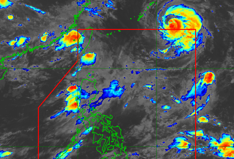
OBET. Satellite image of Typhoon Obet (Saudel) outside the Philippine Area of Responsibility as of August 25, 2026, 4 am. PAGASA Although Typhoon Obet (Saudel) is already outside the Philippine Area of Responsibility, it is still expected to influence the southwest monsoon, which could bring significant rain starting Tuesday, August 25 Typhoon Obet (Saudel) exited the Philippine Area of Responsibility on Monday, August 24, the same day it entered PAR. The southwest monsoon is causing scattered rain and thunderstorms across various regions in Luzon, with significant rainfall expected in several provinces over the coming days. This is AI-generated. Read the article for full context. Report any errors. MANILA, Philippines – Typhoon Obet (Saudel) left the Philippine Area of Responsibility (PAR) at 9:30 pm on Monday, August 24, just around eight hours after its entry. As of 3 am on Tuesday, August 25, Obet was already 1,180 kilometers east northeast of extreme Northern Luzon, moving west northwest at 25 kilometers per hour (km/h). The typhoon weakened, with its maximum sustained winds down to 150 km/h. Its gustiness also eased to 185 km/h. Obet was the Philippines’ 15th tropical cyclone for 2026, and the fourth for August, after Tropical Depression Luis, Tropical Storm Maymay (Kujira), and Tropical Depression Neneng (Gaenari). In its 11 pm bulletin on Monday, the Philippine Atmospheric, Geophysical, and Astronomical Services Administration (PAGASA) had said that Obet may pass close to or make landfall in Japan’s southern islands on Tuesday or Wednesday, August 26, then make landfall again in mainland China by Friday, August 28. PAGASA added that Obet will weaken further in the next few days. It may be downgraded to a severe tropical storm by Friday, and to a tropical depression by Saturday, August 29. However, even after Obet’s exit from PAR, it is still expected to enhance the southwest monsoon or habagat. On Tuesday, the southwest monsoon continues to affect Luzon. It is causing scattered rain and thunderstorms in Metro Manila, the Ilocos Region, the Cordillera Administrative Region, Cagayan Valley, Central Luzon, Cavite, Batangas, and Rizal, as well as isolated rain showers or thunderstorms in the rest of Luzon. PAGASA’s latest rainfall outlook, issued at 5 am on Tuesday, shows significant rain due to the southwest monsoon is now seen to begin during the day, in at least three provinces: Tuesday, August 25 Moderate to heavy rain (50-100 millimeters): Benguet, La Union, Pangasinan Wednesday, August 26 Moderate to heavy rain (50-100 mm): Benguet, La Union, Pangasinan, Zambales, Bataan Thursday, August 27 Moderate to heavy rain (50-100 mm): La Union, Pangasinan, Benguet, Zambales, Bataan, Occidental Mindoro Affected areas should watch out for floods and landslides. Meanwhile, the two other tropical cyclones being monitored outside PAR have since weakened. Atsani was downgraded from a tropical storm to a tropical depression at 2 am on Tuesday. It was last spotted 1,760 kilometers east of Northern Luzon as of 3 am, moving north at 30 km/h. Its maximum sustained winds decreased to 55 km/h, while its gustiness is down to 70 km/h. As for Neneng, it weakened into a low pressure area (LPA) for the second time, also as of 2 am. It is unlikely to redevelop into a tropical depression in the next 24 hours. Neneng was first downgraded to an LPA shortly before its exit from PAR last Thursday, August 20, then redeveloped into a tropical depression on Saturday, August 22. Both Atsani and the LPA that used to be Neneng have no impact on the country. PAGASA previously estimated that up to four tropical cyclones may develop within or enter PAR in August. – Rappler.com How does this make you feel? Loading
Typhoon Obet quickly exits PAR but will still enhance southwest monsoon
Full Article
Original Source
Read the full article at Rappler →KhanList aggregates and links to publicly available news content. We do not host full articles from third-party sources. Always verify important information with original sources.