
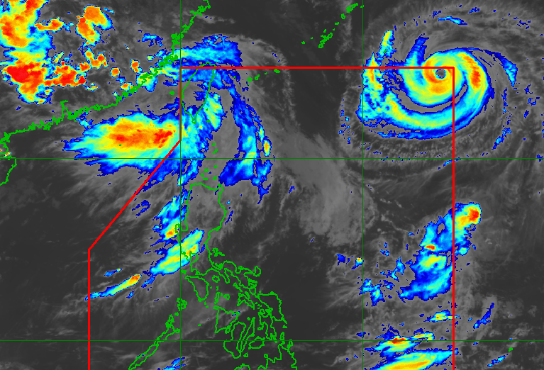
OBET. Satellite image of Typhoon Obet (Saudel) as of August 24, 2026, 4 pm. PAGASA PAGASA says Typhoon Obet (Saudel) may already exit the Philippine Area of Responsibility just hours after its entry, but it is still seen to enhance the southwest monsoon during the week Typhoon Obet (Saudel) is the Philippines' 15th tropical cyclone for 2026. Obet will only briefly stay inside the Philippine Area of Responsibility, but it will eventually enhance the southwest monsoon. The southwest monsoon is likely to bring significant rainfall in the last days of August. This is AI-generated. Read the article for full context. Report any errors. MANILA, Philippines – Typhoon Saudel entered the Philippine Area of Responsibility (PAR) at 1:20 pm on Monday, August 24, and was given the local name Obet. Obet is the country’s 15th tropical cyclone for 2026, and the fourth for August, after Tropical Depression Luis, Tropical Storm Maymay (Kujira), and Tropical Depression Neneng (Gaenari). As of 4 pm on Monday, Obet was located 1,350 kilometers east northeast of extreme Northern Luzon, moving west northwest at 30 kilometers per hour (km/h). The typhoon has maximum sustained winds of 165 km/h and gustiness of up to 205 km/h. The Philippine Atmospheric, Geophysical, and Astronomical Services Administration (PAGASA) said in its 5 pm bulletin that Obet will stay far from Philippine landmass, and may already exit PAR within 12 hours. There are no rainfall or wind warnings due to the typhoon. However, even after Obet leaves PAR, it is still seen to enhance the southwest monsoon or habagat later in the week. The southwest monsoon is currently affecting Luzon and portions of the Visayas. On Monday evening, the southwest monsoon is causing scattered rain and thunderstorms in Metro Manila, the Ilocos Region, the Cordillera Administrative Region, Cagayan Valley, Central Luzon, Cavite, Batangas, and Rizal, as well as isolated rain showers or thunderstorms in the rest of Luzon, Western Visayas, and the Negros Island Region. Flash floods and landslides are possible during periods of moderate to heavy rain or severe thunderstorms. Starting midweek, the enhanced southwest monsoon could trigger significant rain in at least three provinces, particularly the following: Tuesday afternoon, August 25, to Wednesday afternoon, August 26 Moderate to heavy rain (50-100 millimeters): Zambales Wednesday afternoon, August 26, to Thursday afternoon, August 27 Moderate to heavy rain (50-100 mm): Zambales, Bataan, Occidental Mindoro More provinces and regions are likely to be covered by rainfall warnings in the last days of August. The southwest monsoon is also bringing strong to gale-force gusts to these areas: Monday, August 24 most of Luzon, most of Visayas, Northern Mindanao, Dinagat Islands, Agusan del Norte, Surigao del Norte, Davao Occidental, Davao Oriental Tuesday, August 25 most of Luzon, most of Visayas, Zamboanga del Norte, Misamis Occidental, Misamis Oriental, Agusan del Norte, Surigao del Norte, Dinagat Islands, Basilan, Sulu, Tawi-Tawi, Lanao del Norte, Lanao del Sur, Maguindanao del Norte, Sultan Kudarat, Davao Occidental, Davao Oriental Wednesday, August 26 most of Luzon, most of Visayas, Zamboanga del Norte, Misamis Occidental, Misamis Oriental, Agusan del Norte, Surigao del Norte, Dinagat Islands, Basilan, Sulu, Tawi-Tawi, Lanao del Norte, Davao Occidental, Davao Oriental For coastal waters, moderate to rough conditions are expected in the next 24 hours. Up to rough seas (small vessels should not venture out to sea) Seaboard of Batanes; northern seaboard of Babuyan Islands – waves up to 3.5 meters high Western seaboard of Babuyan Islands; northern seaboard of Ilocos Norte; western seaboard of Kalayaan Islands – waves up to 3 meters high Up to moderate seas (small vessels should take precautionary measures or avoid sailing, if possible) Seaboards of Ilocos Sur, mainland Cagayan, Isabela, and Zambales; western seaboards of Pangasinan, Bataan, and Lubang Islands; eastern seaboard of Davao Oriental; remaining seaboards of Babuyan Islands, Ilocos Norte, and Kalayaan Islands – waves up to 2.5 meters high Seaboards of La Union, Aurora, Surigao del Norte, Davao del Sur, and Davao Occidental; western seaboards of Cavite, Batangas, Occidental Mindoro, and mainland Palawan including Calamian Islands; northern and eastern seaboards of Polillo Islands, Catanduanes, and Northern Samar; northern seaboards of Camarines Norte and Camarines Sur; eastern seaboards of Albay, Sorsogon, and Eastern Samar; remaining seaboards of Pangasinan and Lubang Islands – waves up to 2 meters high Meanwhile, PAGASA is still monitoring two other tropical cyclones outside PAR. The tropical depression near the PAR eastern boundary intensified into a tropical storm on Monday morning, and was given the international name Atsani. Atsani was located 1,765 kilometers east of Central Luzon as of 3 pm on Monday, moving east northeast or away from PAR at 35 km/h. It has maximum sustained winds of 65 km/h and gustiness of up to 80 km/h. PAGASA Weather Specialist Grace Castañeda-Carpio said Atsani may either weaken into a low pressure area (LPA) outside PAR or possibly follow Obet’s track and enter PAR. But even if the latter happens, it would not have a direct impact on the country, added Carpio. The other tropical cyclone outside PAR, Neneng, remains a tropical depression. At 3 pm, Neneng was last spotted 505 kilometers north northwest of Itbayat, Batanes, moving northwest at only 10 km/h. It has maximum sustained winds of 45 km/h and gustiness of up to 55 km/h. Neneng had weakened into an LPA and exited PAR last Thursday, August 20, then redeveloped into a tropical depression on Saturday, August 22. It is not expected to reenter PAR. PAGASA previously estimated that up to four tropical cyclones may develop within or enter PAR in August. – Rappler.com How does this make you feel? Loading
Typhoon Obet now in PAR, may eventually enhance southwest monsoon
Full Article
Original Source
Read the full article at Rappler →KhanList aggregates and links to publicly available news content. We do not host full articles from third-party sources. Always verify important information with original sources.