
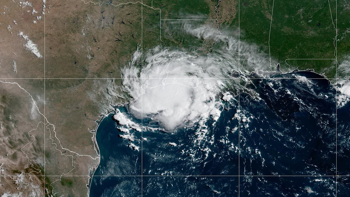
A powerful tropical storm slammed into the US Gulf Coast on Tuesday.Tropical Storm Edouard made landfall near Johnson Bayou, Louisiana shortly after 3pm ET, just east of the Texas state line, while a 71mph gust was recorded nearby at Texas Point.Despite its strength, Edouard had one of the smallest wind fields ever observed in an Atlantic tropical system, limiting the scale of its destruction. However, millions of people across the wider region face a dangerous day of flooded roads, travel chaos, power outages and possible tornadoes.Storm surge could push water as high as eight feet in the hardest-hit coastal locations near Port Arthur, Texas and the Louisiana border.Meanwhile, repeated bands of thunderstorms could dump up to 20 inches of rain in isolated areas by Wednesday, overwhelming drainage systems and potentially cutting off low-lying communities.A tropical storm warning stretches from Port Bolivar, Texas to the Vermilion-Cameron Parish line in Louisiana, while a storm surge warning covers the coast from High Island to Cameron.The bulk of the heaviest rain and strongest gusts is forecast to pass east of the Houston metro, although the city and its surrounding communities could still experience downpours and dangerous travel.The National Hurricane Center (NHC) noted that Edouard should weaken as it moves farther inland, but its flooding and tornado threat could persist for hours after landfall. Tropical Storm Edouard is slamming into the US Gulf Coast, unleashing torrential rain as officials warn of flooding, tornadoes and a dangerous storm surgeA surge of three to six feet is forecast across much of that area, while AccuWeather warned that water could reach a Local StormMax of eight feet in isolated locations.Farther east along the Louisiana coast, forecasters expect a lower, but still potentially dangerous, surge of one to three feet.Storm surge occurs when powerful winds push seawater inland, raising water levels along the coast and flooding roads, homes and businesses. The threat becomes particularly dangerous around bays, rivers and other waterways where rising water can move well beyond the immediate shoreline.Edouard's heavy rain could prove even more disruptive because the storm is moving slowly, allowing bands of thunderstorms to pass repeatedly over the same communities.A broad area of one to two inches of rain is forecast along the Louisiana coast and into eastern Texas through Wednesday. However, totals of two to eight inches are expected across the upper Texas coast, with a smaller corridor east of Houston potentially receiving eight to 12 inches.AccuWeather said the highest isolated total could reach 20 inches where thunderstorms repeatedly track over the same location. The strengthening system began making landfall in Cameron Parish, Louisiana, on Tuesday just after 2pm ET and is forecast to push into southeastern Texas by the eveningJoin the discussionHow should communities balance the need to prepare for extreme weather with the costs and disruptions these storms bring?What's your view?Even areas receiving far less rain could experience street flooding because intense downpours can overwhelm storm drains within minutes. Water may rapidly collect on roads and in underpasses, creating dangerous conditions for motorists and potentially disrupting Tuesday's evening commute.Drivers could encounter sharply reduced visibility, stranded vehicles and roads that appear passable before suddenly becoming submerged.Gusty winds are also capable of bringing down tree limbs and causing sporadic power outages, although damaging winds are not expected to be as widespread as they would be during a major hurricane.Forecasters are additionally warning of waterspouts and isolated tornadoes, particularly within Edouard's eastern and northeastern bands. That danger may continue for several hours after the storm's center has crossed the coast.Edouard marks the third time this hurricane season that the region has faced direct tropical impacts. Tropical Storm Arthur struck Texas in June, followed by Tropical Storm Bertha's Louisiana landfall in July.Some rain will benefit areas experiencing abnormally dry or drought conditions, but the most intense bands could deliver too much water too quickly.Although Edouard will steadily lose strength over land, forecasters warned that residents should not assume the danger ends at landfall. Floodwater, coastal inundation and tornadoes can remain deadly even after the storm's winds begin to weaken.
Tropical Storm Edouard makes US landfall with millions in its path
Full Article
Original Source
Read the full article at Dailymail →KhanList aggregates and links to publicly available news content. We do not host full articles from third-party sources. Always verify important information with original sources.