
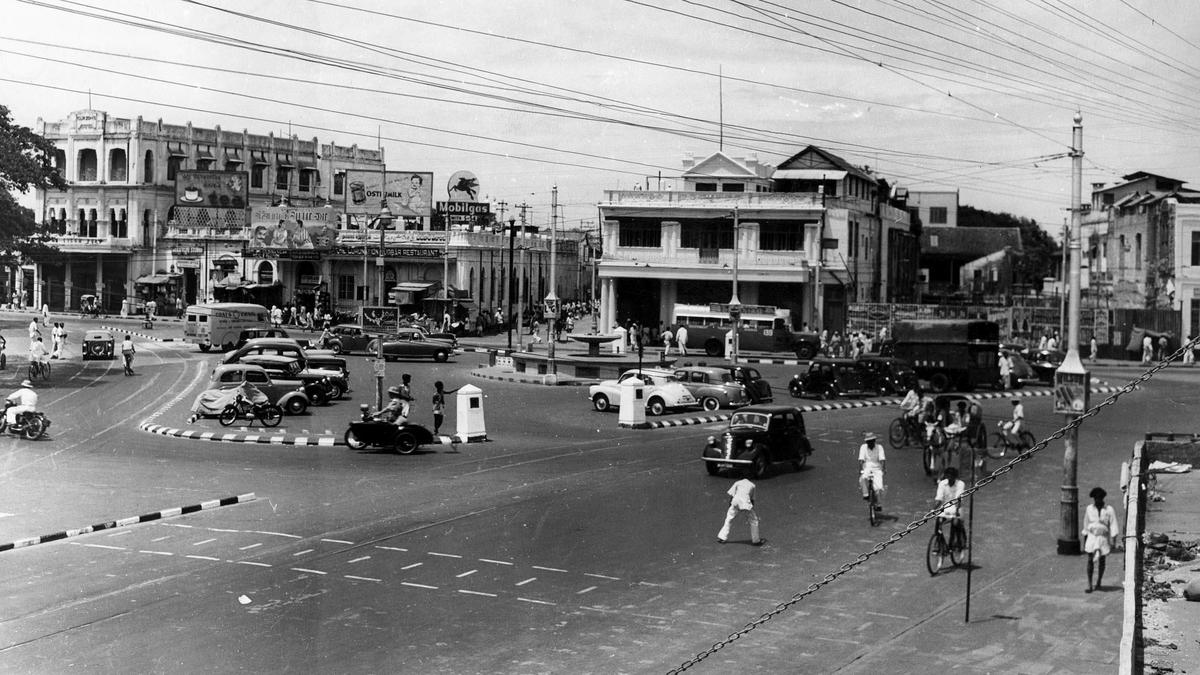
How many of us realise that the focal point as far as the principal roads of our city is concerned still remains Fort Saint George? Traffic movement is by and large planned on the network created by four great roads and no matter how far away you are from the Fort, the routes you take are still dictated by it. The road north sets out from the North Gate of the Fort was known as North Beach Road and then First Line Beach, and now as Rajaji Salai, which under other names connects to Minjur, Manali, Pulicat, and onwards to Andhra. | Photo Credit: S.S. Kumar The road north sets out from the North Gate of the Fort. In its time, it was known as North Beach Road and then First Line Beach. Today, it is Rajaji Salai, which under other names connects to Minjur, Manali, Pulicat, and onwards to Andhra.In the late 1790s, the government decided that ships would not stop opposite Fort Saint George but further north and moved the customs house to North Beach Road. This meant all the British business houses of Madras shifted out of the Fort and established themselves there.To help in their trade, the railway terminus came up at the northern extreme of this road at Royapuram. The harbour was built here, and the general post office and later the principal bank, namely the Bank of Madras, were established here.North Beach Road would be connected by the tram service and the suburban railway as it needed to ferry passengers to the offices. Today, it may just be a road leading north, but on its left are the relics of commercial establishments that once defined the prosperity of our city. South Beach Road, now Kamarajar Salai, which used to be a leisure destination for the British later became the home of Indo-Saracenic architecture and several landmark buildings of administrative and educational purpose. | Photo Credit: The Hindu Archives If North Beach Road defined commerce, its southern counterpart, South Beach Road, and today, Kamarajar Salai, was all about leisure. The British took in the air here, crossing over from the Fort via Napier’s bridge and earlier to it by boat.In an era prior to that, they brought their carriages to a point known as Cupid’s Bow, which is today occupied by the War Memorial.South Beach Road later became the home of Indo-Saracenic architecture and several landmark buildings of administrative and educational purpose. Amid them is Ice House, reminding us of a time when this precious commodity was brought in from the United States of America by ship.South Beach Road, emerging from St. Thomas’ Gate of the Fort connects us via the East Coast Road to Pondicherry, Cuddalore, and beyond. The Buckingham Canal ran parallel to it as a navigable waterway. The Mass Rapid Transit System came up alongside, and soon, so will the Metro Rail. Poonamallee High Road, now EVR Periyar Salai, was meant to connect to the Nayak of Poonamallee, but it came to be the thoroughfare on which great public services were planned. It is still the spine on which several later areas of the city sprang up, and it connects us to Bengaluru and beyond. | Photo Credit: The Hindu Archives Radiating west from the Fort’s St. George’s Gate is Poonamallee High Road, now EVR Periyar Salai. In its time, it was meant to connect to the Nayak of Poonamallee, but it came to be the thoroughfare on which great public services were planned ranging from hospitals, stations, and the town hall to municipal buildings, the market, and places to stay. Poonamallee High Road is still the spine on which several later areas of the city sprang up, and it connects us to Bengaluru and beyond.Lastly, we come to Mount Road, now Anna Salai. It connects Wallajah Gate of the Fort to St. Thomas’s Mount, where the garrison was located. It was widened to facilitate easy movement of the army, but became the spine on which commercial establishments, chiefly retail, made their headquarters.The automobile revolution of Madras was created by the car retailers of Mount Road. It was once the fashionable downtown, but now is just a road that takes us southwest. In its avatar as the Grand Southern Trunk Road, it takes us to Tiruchi. You can never escape these four routes, if you cut across Chennai. Even the Ring Roads came up to connect these at their peripheries.
The four key roads of Madras that originate from Fort St. George
Full Article
Original Source
Read the full article at Thehindu →KhanList aggregates and links to publicly available news content. We do not host full articles from third-party sources. Always verify important information with original sources.