
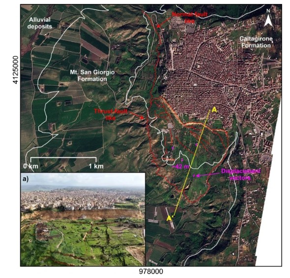
Map showing major deformational features of the Niscemi landslides. Inset picture a depicts the western sector of the upper part of the southern Niscemi landslide (last access 06 August 2026; https://www.meteoweb.eu/2026/02/ciclone-harry-e-niscemi-la-consulta-degli-ingegneri-propone-una-task-force-tecnica-a-supporto-della-regione/1001896651/). From Guerriero et al. (2026), published under a CC license. On 25 January 2026, a very large landslide reactivated at Niscemi in Sicily, Italy. A new paper in the journal Landslides (Guerriero et al. 2026) describes the event. On 25 January 2026, a large landslide reactivated at Niscemi in SE Sicily, Italy. The landslide attracted a great deal of media attention. About 1,500 people were evacuated from this historic town, and the landslide damaged infrastructure and buildings. A first analysis (Guerriero et al. 2026) of this event has been published in the journal Landslides. The good news is that this article is both open access and published under a Creative Commons License. Niscemi is located at [37.1467, 14.3973]. It is a historic town built on a mesa formed from sandstones and clays that overlie a layer of gypsum. It is well documented that a large landslide occurred 18 March 1790 on the southern side of the mesa. This landslide reactivated on 12 October 1997 over an area of about 2 km2. It is this slope that reactivated once more in January 2026. Guerriero et al. (2026) have included this image of the most recent reactivation:- Guerriero et al. (2026) show that the landslide was triggered by rainfall associated with Cyclone Harry, which passed over the area the week before the failure. It affected an area of about 1.3 km2, with a maximum length of about 1.3 km. The authors have used InSAR to examine as to whether there was ongoing or precursory deformation. Interestingly, this analysis shows very limited movement on only a small part of the landslide complex. Most of the mass was stable, which is a fascinating result for this large system. The 25 January 2026 movement event at Niscemi was very significant. The authors describe total movement of up to about 50 metres. It is unsurprising that this caused significant damage. Guerriero et al. (2026) have provided an indicative cross-section of the landslide:- Geological section reconstructed on the basis of available literature data…Purple lines indicate potential pre-existing failure surfaces interpreted along the considered profile on the basis of data from Rizzo (2004) and main deformational features distributions. From Guerriero et al. (2026), published under a CC license. So this is quite a deep-seated failure (70 metres) on a low angle shear surface, which will have been driven primarily by weak materials and high pore water pressures. Sicily has quite a dry climate, so the rainfall totals that triggered this landslide are remarkably low. Guerriero et al. (2026) describe less than 35 mm of rainfall in the week before the failure, with much of that (21.0 mm) falling on 20 January 2026. It is interesting that the media coverage largely focused on perceived decades of neglect by the civic authorities with regard to a known and understood landslide threat – see for example this article in the Guardian: “According to geologists and environmental experts, the landslide in Niscemi is the latest sign of how the climate emergency is reshaping the Mediterranean, where there has been indifference to decades of flawed building policies and an out-of-control model of urbanisation.” The article by Guerriero et al. (2026) does not really consider this element of the Niscemi landslide, which is intriguing. References Guerriero, L., Di Martire, D., Annella, C. et al. 2026. The reactivation of the Niscemi landslide (southern Italy) after the Cyclone Harry. Landslides. https://doi.org/10.1007/s10346-026-02857-z Rizzo, V. 2004. Un vasto movimento gravitativo al fronte della falda di Gela; evidenze e problematiche in relazione alla tettonica (Frana di Niscemi, Sicilia Meridionale). Bollettino della Società Geologica Italiana 123, 229–252 Text © 2026. The authors. CC BY-NC-ND 3.0Except where otherwise noted, images are subject to copyright. Any reuse without express permission from the copyright owner is prohibited.
The 25 January 2026 landslide at Niscemi in Sicily, Italy
Full Article
Original Source
Read the full article at Eos →KhanList aggregates and links to publicly available news content. We do not host full articles from third-party sources. Always verify important information with original sources.