
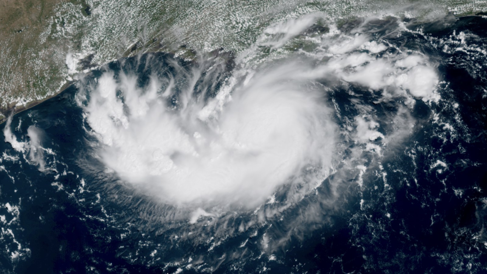
Tropical Storm Warning flags were flying today on the Gulf Coast of southeast Texas and southeast Louisiana ahead of the expected arrival on Tuesday of Tropical Depression Five (TD 5), which was designated a tropical depression at 2 p.m. EDT Monday. As of 11 a.m. EDT Monday, TD 5 was predicted by the National Hurricane Center to become a tropical storm before its center reaches the TX/LA coast on Tuesday afternoon. The next name on the Atlantic list is Edouard. Satellite imagery and Hurricane Hunter transects on Monday morning showed TD 5 to have a closed circulation, albeit a weak and elongated one, with top sustained winds of only 35 mph (55 km/h). As seen in the image at top, TD 5’s cloud shield was largely focused on its south side. TD 5 is also an unusually small system, with a compact core of showers and thunderstorms that’s smaller than some Great Plains supercell thunderstorms. However, small tropical systems can both intensify and weaken more quickly than big ones. #BREAKING: We now have Potential Tropical Cyclone Five in the Gulf. #PTC5 is forecast to become Tropical Storm #Edouard and make landfall in SE Texas or SW Louisiana on Tuesday. A hurricane can’t be ruled out. Residents there should be preparing for tropical storm force winds,… pic.twitter.com/v7mZUhYfgC— Dylan Federico (@DylanFedericoWX) August 31, 2026 Very dry air surrounds TD 5, with mid-level relative humidity below 50 percent; this is the main obstacle to its strengthening (and also a big reason why it’s such a small system). However, TD 5 is traversing unusually warm waters for the end of August: sea surface temperatures of 31 degrees Celsius (88 degrees Fahrenheit) along its path are about 1°C (1.8°F) above average. (See Fig. 1 below for a sense of how unusual this is). These toasty waters, combined with light wind shear, may give TD 5 a brief window for potential development that could be rapid. The SHIPS statistical model on Monday morning gave TD 5 a 21% chance of becoming a higher-end tropical storm with sustained winds of 65 mph (105 km/h) by Tuesday morning, a few hours before expected landfall. Short-range intensity models may not have a solid handle on TD 5 before it forms a more robust circulation (assuming it does). Figure 1: Ocean Climate Shift Index in the northern Gulf of Mexico where TD 5 is developing shows that human-caused climate change has made the above-average temperatures of these waters about 60-70 times more likely to occur. (Image credit: Climate Central) If it behaves as predicted, TD 5 will follow in the footsteps of the year’s four named Atlantic systems to date, all of which stayed below hurricane strength. Only Tropical Storm Bertha mustered sustained winds of at least 50 mph — and only Bertha lasted for more than 24 hours as a named storm (July 20-24) as it churned west along the upper Gulf Coast. Yet this season also reminds us how destructive even a weak, short-lived storm can be. Torrential rains associated with Tropical Storm Arthur (June 17-18) took at least four lives and wreaked more than $1 billion USD in damage from northern Mexico across Texas to southern Louisiana. TD 5 expected to ease long-term drought conditions in Texas/Louisiana Assuming it develops modestly, as expected, the compact core of TD 5 will dump as much as 4-8 inches of rain wherever it makes landfall. This is far less than many tropical systems produce in the area, and it could be more of a boon than a bane. According to the U.S. Drought Monitor, the coastal region near the Texas/Louisiana border is in moderate drought (level 1 out of 4 on the Palmer Drought Severity Index). NOAA says that as of August 28, the region needs 12-14 inches of rain in one month to pull them out of long-term drought conditions. Remnants of Dolly bring meager rains to Puerto Rico In Puerto Rico and the Virgin Islands, the remnants of Tropical Storm Dolly brought fairly meager rains of 1-3 inches on Sunday to a region suffering widespread severe to extreme drought. Much more precipitation than that was needed to make a noticeable dent in their drought conditions. Dolly’s remnants will continue to the west-northwest over the next few days, potentially bringing some heavy rain showers to the Bahamas, Hispaniola, and the Turks and Caicos Islands. High wind shear will likely prevent development, and in their 8 a.m. EDT Tropical Weather Outlook, NHC gave Dolly’s remnants 2-day and 7-day odds of development of 0% and 10%, respectively. A rapid-attribution study by climate scientists with World Weather Attribution found that “human-induced climate change has reduced early wet season rainfall by 6% in Jamaica and 9% in Puerto Rico, making precipitation this low 20% and 40% more likely to occur, respectively, compared to a pre-industrial climate. Under a 2.8°C global warming scenario, early wet season rainfall across the Caribbean is projected to drop by about another 10%, increasing the likelihood of further droughts and underlining the need for investment in adaptation and infrastructure.” Rain is expected today, Monday, in PR & DR due to trailing moisture behind the remnants of Storm Dolly. However, 24-hour rainfall totals recorded up to this morning undoubtedly leave much to be desired, especially in the watersheds that need it most. Preliminary data via @cocorahskyjc6.bsky.social— John Morales (@johnmoralestv.bsky.social) 2026-08-31T12:55:52.678Z Karina, Lowell, and maybe Marie: A nonstop lineup of tropical cyclones roils the Eastern Pacific Over the next couple of weeks, it’s not out of the question that the United States could see more consequences from tropical systems in the Pacific than in the Atlantic. Turbocharged by El Niño, the Eastern Pacific hurricane season continues at a rip-roaring pace. On Monday, there was a Category 4 hurricane in progress (Karina), another tropical storm predicted to reach Cat 3 strength by midweek (Lowell), and a third system that could develop into a hurricane by the weekend (the next name on the Pacific list is Marie). Lowell will push heavy surf and potentially strong winds into the Hawaiian islands, with Karina possibly doing the same, while the third system could swing close to southern California next week as a rain-producing tropical storm. Figure 2. From left to right, this infrared satellite image shows Tropical Storm Lowell, Hurricane Katrina, and the disturbance Invest 95E lined up in the tropical Eastern Pacific Ocean at 1655Z (12:55 p.m. EDT) Monday, August 31, 2026. Also visible are heavy showers and thunderstorms redeveloping after Sunday’s deadly flash flooding (see discussion below). (Image credit: tropicaltidbits.com) Lowell was centered nearly 800 miles (1,300 km) southeast of Hilo, Hawaii, as of 11 a.m. EDT Monday, with top sustained winds of 65 mph (100 km/h). Conditions will be close to ideal for Lowell to strengthen rapidly, with light wind shear of 5-10 knots and unusually warm sea-surface temperatures of around 29°C (84°F). Dry air is the only potential impediment to Lowell becoming a major hurricane. On Monday morning, the SHIPS statistical intensity tool D-TOPS gave Lowell an 82% chance of building top sustained winds of 140 mph (mid-range Category 4 strength) by Thursday morning. By that point, Lowell’s gale-force winds are predicted by the National Hurricane Center to extend more than 125 miles (200 km) north of Lowell’s center. That would still be well shy of the 250 mi (400 km) needed to reach the south tip of the Big Island in this forecast, but at least gusty winds and perhaps outer-edge squalls could reach the island by late week, along with large swells. As of 11 a.m. EDT Monday, Karina was packing top sustained winds of 140 mph (225 km/h). This may be the hurricane’s peak strength, as Karina will encounter gradually cooler waters over the next few days while it plows into increasingly dry air (relative humidity below 40 percent by Wednesday). Karina may end up morphing into an annular hurricane, one with a “truck tire” wall of convection (showers and thunderstorms) that helps shield its moist inner core. If so, this could slow down its weakening. In the longer range, some members of the GFS and Google DeepMind ensemble models suggested early Monday that a weakened, westward-bending Karina could move near or just north of Hawaii early next week. It’s far too soon for any confident forecasts, as there’s already a great deal of spread in the models, and whatever Lowell does may influence Karina’s track. There’s also Invest 95E, a disturbance lurking on Monday over the tropical Eastern Pacific several hundred miles south-southwest of Puerto Vallarta, Mexico. Given its 90% odds of development within 48 hours, it’s possible 95E will be Tropical Storm Marie as soon as Tuesday. There’s strong model consensus that Marie will parallel the coast while intensifying – perhaps rapidly – over the next few days, moving over exceptionally warm water of 31°C (88°F), up to 3°C (5°F) above average. The bigger question lies toward early next week, which could bring a powerful Hurricane Marie angling more northward. Almost half of the members of the GEFS ensemble run from early Monday morning (6Z) brought the future Marie toward landfall over far northern Baja California, with remnants sweeping toward Arizona, and a few other GFS and Google DeepMind ensemble members suggested a westward-arcing path off Southern California. Much cooler waters toward SoCal typically weaken any tropical systems approaching from the south, but such a track needn’t be a full-on landfall to push moisture and potentially heavy rain inland, not to mention pushing high surf toward shore. As with Karina, there’s plenty of time to see how the modeling evolves on 95E. As our high-end El Niño summer heads into fall, #Hawaii will continue to try to dodge big hurricane impacts. #Lowell could be a close call based on when it turns north. Currently models seem to be trending west of the islands, but it's too early to say for sure. And #Karina could… pic.twitter.com/eTjugIF0ys— Andy Hazelton (@AndyHazelton) August 30, 2026 An extremely busy hurricane season for Hawaii Lowell and Karina will be the fourth and fifth named storms to come close to Hawaii this year. This is one of the highest levels of tropical cyclone activity on record for the state. Hawaii’s other three named storms of 2026: Tropical Storm Moke passed several hundred miles south of Hawaii’s Big Island as a low-end tropical storm with 40 mph (65 km/h) winds on August 22, bringing 1-3 inches of rain to portions of the Big Island. Moke caused no significant damage to the island. Hurricane Lala passed about 30 miles (48 km) southwest of the southern tip of the Island of Hawaii (aka the “Big Island”) on August 15 as a Category 1 hurricane. The storm’s northeastern eyewall briefly pushed ashore, bringing tropical storm-force winds to southern portions of the island. However, Lala’s heavy rains were by far the most serious threat, bringing destructive flash flooding and landslides. Lala killed two people on the Big Island and did hundreds of millions in damage. The highest total rainfall was 43.54 inches at Laupahoehoe, a coastal town about 25 mi (40 km) northwest of Hilo. According to Michael Lowry, Lala will likely go down as one of the top 10 wettest tropical cyclones on record for the U.S. and perhaps the third-wettest to affect Hawaii, only behind Lane in 2018 and Hiki in 1950, which brought rainfall totals of 58 inches and 52 inches, respectively. Hurricane Fausto, the first hurricane of the 2026 eastern North Pacific season, reached Category 2 strength in mid-July as it tracked westward into the central Pacific toward Hawaii. High wind shear, dry air, and cooler water temperatures weakened the hurricane, and on July 29, Fausto degenerated to a remnant low with 35 mph winds as it passed 285 miles (460 km) north of Hilo on the Island of Hawaii. According to insurance broker Aon, Fausto caused negligible damage in Hawaii. ⚠️ UPDATE: Significant flash flooding in Bright Angel Canyon has closed Phantom Ranch, Bright Angel Campground, the entire North Kaibab Trail to Phantom Ranch, Black Bridge, Silver Bridge and the Colorado River to river traffic until further notice.As of this morning, 62 people… pic.twitter.com/oohovKcax9— Grand Canyon NPS (@GrandCanyonNPS) August 30, 2026 Deadly flash flood hits the bottom of Grand Canyon A destructive flash flood swept down Bright Angel Creek at the bottom of Grand Canyon Saturday evening, ripping through the famed Phantom Ranch at the creek’s juncture with the Colorado River. One body has been recovered, and 15 people are missing after 62 others were helicoptered out. The only water pipeline supplying water to the canyon’s tourist facilities was damaged, and all hotels at Grand Canyon National Park are now closed indefinitely for overnight lodging. According to National Weather Service meteorologist Darren McCollum in Flagstaff, who was quoted by the Associated Press, about half an inch to 1 inch (1 to 2.5 cm) of rain fell within about 20 minutes on a rocky slope where there’s a steep drop in elevation. “So when the main storm moved in, torrential rain fell on everything that was already soaked, and that caused all the problems that we’re seeing,” McCollum said. A portion of the rain fell in the burn scar of the 2025 Dragon Bravo Fire, which destroyed vegetation both along the North Rim of the canyon and below the rim. The lack of vegetation allowed the flood waters to run off more quickly. The Grand Canyon was under a “Marginal Risk” (level 1 out of 5) for dangerous flash flooding that day because of the monsoon. In addition, residual moisture from Tropical Storm Iselle contributed to the event. Precipitation so far this month at nearby Flagstaff has been less than half of average (1.23 inches vs. an average of 2.95 inches). Saturday’s rainfall of 0.39 inches at Flagstaff was the largest amount of any day in August. Conditions appear to be more dangerous today, with a “Slight” (level 2 out of 5 risk) in effect. A Flash Flood Watch is posted for the Grand Canyon. Significant infrastructure damage occurred at Phantom Ranch, and I (Jeff Masters) was saddened to see a video of what could have been the bunkhouse that I stayed at during my honeymoon floating down the Colorado River. I have fond memories of the most awesome hot shower I’ve had in my life and of a spectacular breakfast buffet served before the 7 a.m. checkout time. (It’s probably the only hotel with a checkout time so early — they want you to hit the trail early to have time to make it up the rim, at least 7 miles by trail and a vertical mile up.) Irene Sans contributed to this post. Republish our articles for free, online or in print, under a Creative Commons license.
Texas and Louisiana could get hit by a fast-spin-up tropical storm on Tuesday
Full Article
Original Source
Read the full article at Yaleclimateconnections →KhanList aggregates and links to publicly available news content. We do not host full articles from third-party sources. Always verify important information with original sources.