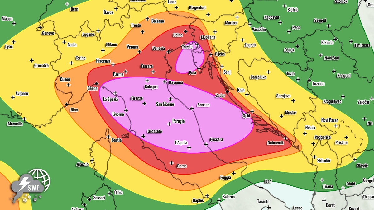
Severe weather outlook – forecast across Europe. This forecast features areas of organized severe weather with risk levels and severe weather threats across the European continent. Valid: 26/07/2026 06 UTC – 27/07/2026 06 UTC Issued by: Severe Weather Europe Forecaster: Marko Korošec SUMMARY A significant severe weather outbreak is forecast across the north-central Mediterranean and the Adriatic Sea region on Sunday. Strong instability and highly sheared environments combine for widespread thunderstorm activity with large to giant hail, severe winds, tornadoes, and flash flood potential. A large upper-level trough has established over northern Europe, with a strong blocking High over the Atlantic. Over the Mediterranean region, the secondary wave moves across Italy as the subtropical ridge to the south shifts further east. This wave results in a widespread severe weather outbreak for north-central Italy and a portion of the Adriatic Sea where volatile environmental conditions combine. Severe thunderstorms will support severe, damaging winds, large to very large (or even giant, 10+ cm) hail, a few tornadoes, and especially intense, excessive rainfall with a flooding threat. This outlook focuses on Sunday’s evolution, when a significant severe weather event is from the Ligurian Bay across the north-central Apennines into the Adriatic Sea as the upper wave emerges over the Alps towards the northern Mediterranean. Robust thunderstorms are expected from the early morning hours across northern Italy and intensify towards the Adriatic throughout the day. Above: Video animation of the convective storm’s development across the Mediterranean from Sunday morning through Monday morning, July 26th to 27th, 2026. For this reason, HIGH + MDT risks have been placed across portions of Italy and the Adriatic Sea, with highlighted areas where the most robust severe weather threat will develop on Sunday. The threat includes enhanced potential for severe damaging winds, flash floods, tornadoes, and very large to giant hail (6-10 cm or larger). SYNOPTIC OVERVIEW A deep upper-level low centered over northern Europe remains almost stationary on Sunday, locked in between two strong upper ridges over the North Atlantic and Russia. Further south, a secondary wave moves across central Europe towards the east. This will establish a typical volatile setup for the north Mediterranean region. At the surface, an extensive and deep low-pressure system is centered along western Norway, with a secondary low forming in the northern Mediterranean in response to the upper wave moving into the region aloft. This results in a frontal system entering Italy, with the cold front moving west to east across the Alps and northern Mediterranean into the Adriatic Sea and western Balkans on Sunday. WEATHER FORECAST DISCUSSION – Sunday, July 26th +++ Weather forecast for Italy, Austria, Slovenia and Croatia +++ Explanations for abbreviations (TSTM, SLGT, ENH, etc.) Highlighted severe weather threats: Tornado potential: Medium Maximum hail size: More than 8 cm Peak wind gusts: Up to 120 km/h 24-hour rainfall: More than 150 mm HIGH risk has been issued for central and northern Italy and into the central Adriatic Sea. The threat includes severe damaging winds, very large to giant hail, torrential and excessive rainfall with flash floods, and tornadoes. HIGH risk has been issued for the northeast Adriatic Sea into northwest Croatia (Istria) to southwestern Slovenia. The threat includes torrential and excessive rainfall with flash floods, severe winds, large hail, and possibly waterspouts/tornadoes. MDT/ENH/SLGT risks have been issued for areas surrounding the HIGH risk areas, including south and western Croatia, western and central Slovenia, west-central Austria, southern Switzerland, and north-central Italy, with a threat for severe winds, large hail, and torrential rainfall. The expected storm coverage is forecast to be lower than inside the highlighted purple risk area. Ahead of an emerging frontal system from the west, powerful south-westerlies aloft are advecting high moisture from the central Mediterranean region towards the northern Mediterranean region. Given the ongoing extreme Mediterranean heatwave, high dewpoints will result in moderate to locally extreme instability, with MLCAPE reaching 2000 to 3000+ J/kg over the Tyrrhenian, Ligurian, and central Adriatic Seas. At the same time, ample wind shear is also overspreading the region, thanks to the intense jet mid-level stream aloft. Therefore, a strong forcing develops near the left-exit region of the jet. A combination of intense wind shear and high instability will lead to a volatile environment with the explosive development of severe thunderstorms from early Sunday morning, starting from the Ligurian Bay towards the Apennine Mountains. Training multicell thunderstorms and intense supercells are expected as the primary mode, pushing high moisture into the complex terrain of northern Italy in an impressive high-PWAT (45-60 mm) environment. Extremely intense rainfall is forecast. +++ Weather forecast for North Adriatic, SW Slovenia and NW Croatia +++ Another area of interest for severe weather is along the nose of the low-level jet emerging across the North Adriatic where stationary convergence could form. Trailing cells could lead to excessive rainfall within 6-12 hours during the day, bringing rainfall accumulations into the 100-200 mm range across a wide area according to some high-resolution models. Dangerous flash floods could occur along the coasts of Istria, Croatia if these predictions are accurate and affect the region where peak summer season is underway. Strong southeast low-level flow also hints at tornadic supercells. The tornado threat is maximized across the western portions of the HIGH risk area in central Italy where the highest storm-relative helicity and low-level shear will be present. In addition, tornadic potential is enhanced across the second HIGH risk in the North Adriatic, along stalled surface convergence, with intense low-level shear during the day. Given the high wind shear and instability combined, most thunderstorms will rapidly become severe and be fast-moving across the highlighted areas, with threats ranging from large, wind-driven hail to severe, damaging winds, torrential rainfall, and tornadoes. Storms will merge into large clusters as they move east as the upper wave travels across. +++++Isolated severe storms are also possible in the western Mediterranean, between northeast Spain and the Balearic Islands. Those could pose a threat for severe winds, large hail, and torrential rainfall. An ENH risk has been issued to highlight the highest potential in the region. Highlighted severe weather threats: Tornado potential: Low Maximum hail size: Up to 4 cm Peak wind gusts: Up to 90 km/h 24-hour rainfall: Up to 75 mm Additional storms are possible along the southern edge of the main upper wave, extending from the Netherlands across northern Germany to Poland, where a SLGT risk area has been issued. Some storms could become severe with severe winds and marginal hail. A large ENH/SLGT risk has also been issued for southwestern Russia, where a combination of high instability and a strongly sheared environment will likely support discrete organized supercell storms, posing a threat for severe, damaging winds, torrential rain, and large hail. Tornadoes will also be possible given the relatively strong low-level shear and enhanced helicity. Meteoadriatic, Wxcharts, and PivotalWeather provided images used in this article.
Severe Weather Forecast / Outlook for Europe – July 26th, 2026
Full Article
Original Source
Read the full article at Severe-weather →KhanList aggregates and links to publicly available news content. We do not host full articles from third-party sources. Always verify important information with original sources.