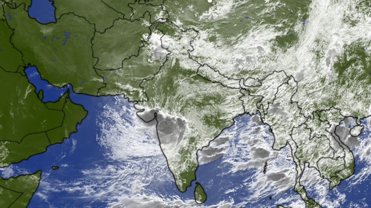
Seven weather systems are working over India at once. Here is how each one works and why the rains are set to swing toward the Himalayan foothills, Bihar and Assam with rising flood risk.India's monsoon is running on seven weather systems at once this week, from the Somali Jet feeding moisture off the Arabian Sea to a deep depression over Gujarat. (Photo: Windy)You cannot see it, and you will never feel it on your skin, yet a narrow river of wind sliding across the Arabian Sea tonight is quietly deciding whether Bihar floods next week, or Assam’s deluge worsens.That wind is one of seven weather systems now working the skies over India at once, a rare convergence the India Meteorological Department (IMD) is tracking.Most days, the monsoon runs on two or three moving parts.Right now it runs on seven, behaving less like separate storms than the gears of one enormous machine. Here is what the whole assembly is about to do to the rains. WHAT IS THE SOMALI JET?Start with the engine. The Somali Jet, or Findlater Jet after the meteorologist who mapped it in 1969, is a low-level jet, which means a fast, narrow ribbon of wind close to the ground, not high where aeroplanes cruise. This one lives barely a kilometre and a half above the sea.Born near Madagascar, it races north, crosses the equator off the Somali coast, and there the spin of the Earth bends it into the strong southwesterly current that charges across the Arabian Sea into India's west coast. The science on this jet calls it the main moisture carrier for the whole monsoon. Skimming a warm, evaporating sea, it lifts vast quantities of water vapour, the invisible gas form of water, and hands it inland for everything else to wring out as rain.When it strengthens, as the IMD expects this week, the monsoon has more fuel to burn.WHAT IS A DEEP DEPRESSION?Now the loud one. A depression is a patch of atmosphere where the air is lighter than its surroundings, so winds spiral inward. The IMD grades these by wind speed: a plain depression runs 31 to 49 kilometres per hour, a deep depression 50 to 61, one rung below a named cyclonic storm.This system was born over the Bay of Bengal, came ashore near the West Bengal and Odisha coasts around July 27, and has hijacked the west-northwest ever since.As it spins, it drags moist air inward, forces it upward and lets it condense, releasing stored energy called latent heat, the warmth a cloud returns when vapour becomes rain. That warmth feeds the loop, which is how these systems keep raining far from any sea.The IMD places its centre over Vidarbha, still tracking toward Gujarat, and warns of extremely heavy rainfall, 21 centimetres or more in a day, over Gujarat on July 31 and August 1.WHY IS THE MONSOON TROUGH SHIFTING NORTH?The third piece is the spine of the season. The monsoon trough is a long belt of low pressure, not a swirl but a line, stretching from northwest India across the Gangetic plains to the Bay of Bengal, and where it sits decides where the heaviest rain falls.For days the deep depression has anchored its eastern end over central India.As the depression drifts west and weakens over land, that grip loosens and the trough springs north toward the Himalayan foothills.This is the pivot on which the whole forecast turns: when the trough climbs to the mountains, the central plains rest while the foothills take the force.WHAT IS THE EAST-WEST SHEAR ZONE?Near latitude 21 degrees north sits a shear zone, a belt where wind speed or direction changes sharply between one height and the next.It gathers scattered clouds into disciplined rain bands across central India, sharpening the downpours the depression is already delivering.WHAT IS THE OFF-SHORE TROUGH?Running down the west coast from south Gujarat to north Kerala is the off-shore trough, a coastal line of low pressure.It keeps the rain switched on over Konkan, Goa and coastal Karnataka by nudging moist Arabian Sea air to gather and rise along the shore.WHAT IS A WESTERN DISTURBANCE?Far to the north is a Western Disturbance, a rain-bearing system that travels in from the Mediterranean on the high westerly winds, now spinning as a cyclonic circulation, a swirl of air, over Punjab and Haryana.Where it meets monsoon moisture, it lifts rainfall over the northwest hills.WHAT IS THE ASSAM CYCLONIC CIRCULATION?Over central Assam, a low-level cyclonic circulation, a gentle spin of near-surface air, keeps moisture piled up over the northeast, and it will prove decisive for that region's flood risk in the days ahead.HOW WILL THE MONSOON CHANGE THIS WEEK?The choreography is elegant and a little ominous. The Somali Jet keeps the moisture coming.The deep depression, even as it fades over Gujarat, keeps central and western India wet, so Maharashtra, Madhya Pradesh, Gujarat and eastern Rajasthan face waterlogging and overflowing streams.Then the handover begins. As the trough lifts north, Bay of Bengal moisture is thrown against the Himalayas. Air cannot climb a mountain gently; it is shoved upward, cools and dumps its water, a process called orographic lifting, where the terrain itself makes the rain.From the night of July 31 into August 1, light showers over Bihar and eastern Uttar Pradesh thicken into steady rain, then spread along the foothills of Nepal, Bihar, UP, north Bengal and the northeast.WHICH REGIONS FACE THE HIGHEST FLOOD RISK?The sharpest danger sits over Upper Assam and the northeast, where the Assam circulation and the arriving trough combine over soaked ground, with the Brahmaputra near its danger marks.Rain falling on Nepal's slopes pours into north Bihar and eastern UP within hours, lifting rivers fast.In Himachal Pradesh and Uttarakhand, the Western Disturbance layered over monsoon air raises the odds of landslides and flash floods.If you live in a low-lying stretch of these basins, the oldest advice holds: move to higher ground before the water tells you to.WHAT DOES THIS MEAN FOR FARMERS AND RESERVOIRS?There is a credit side. A week of widespread rain refills reservoirs that guarantee drinking water and hydropower, recharges the shallow groundwater the Gangetic belt leans on, and gives paddy, pulses, cotton and oilseed growers the moisture they need for a healthy kharif, the monsoon cropping season.The catch is rhythm. Rain delivered gently over days nourishes; the same rain in violent bursts drowns young crops and strips hillside soil. Which one the week brings depends on how these seven systems keep passing the baton.That is the strange truth of the Indian monsoon.It is never one thing arriving. It is a committee, and this week the committee is unusually crowded.- EndsPublished By: Radifah KabirPublished On: Jul 31, 2026 08:00 IST
Seven weather systems now steer India's monsoon: Heavy rain, floods ahead
Full Article
Original Source
Read the full article at Indiatoday →KhanList aggregates and links to publicly available news content. We do not host full articles from third-party sources. Always verify important information with original sources.