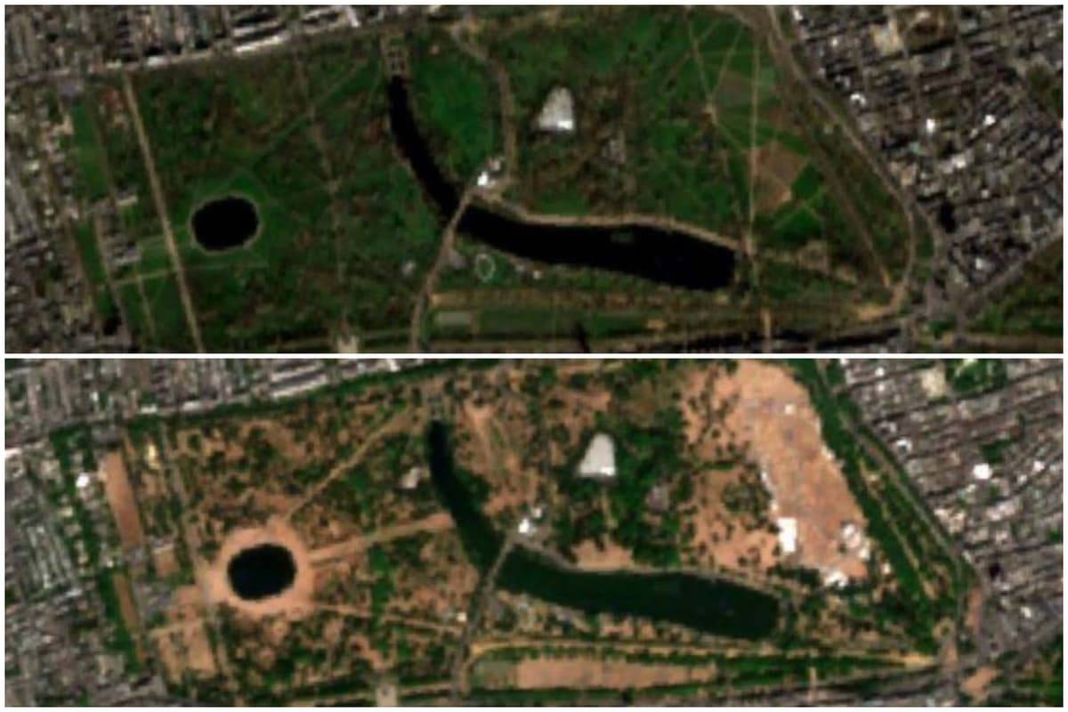
The full scale of the devastating impact of unprecedented heatwaves on London’s landscape is revealed today.Exclusive satellite imagery produced by geospatial analytics company Map Impact for The Standard shows how the capital’s parks, gardens and other green oases are being frazzled into parched lands.Normally, London is one of the greenest capitals on earth, boasting “crown jewel” parks like no other city.The images from space lay bare the impact of virtually no rain for weeks and record temperatures, no more so than in Victoria Park, in Tower Hamlets, the capital’s oldest public park.Its normally lush, green acres are now vast, straw-coloured areas.The dramatic transformation has happened in just months.The satellite snaps show how the park looked in March - before the global warming-fuelled extraordinary heat hit Britain - and then in July. The “People’s Park”, as it has been known over the years, was opened in 1845 for the benefit of the East End working class, and sprawls across 86 hectares as part of a “green corridor” in the capital.But the park, visited by more than nine million people a year, is now far from green.Its remaining grass and other vegetation is set to further wilt in the “extreme” heat forecast to peak on Thursday.The capital’s iconic Royal Parks are famous for their wildlife and floral diversity.The Serpentine waters normally split two large green, grassy areas which make up Hyde Park and Kensington Gardens.But both Royal parks have been hard hit by the scorching weather.Nina Moiseeva, Chief Scientist at Map Impact, said: “From space, London’s summer landscape has visibly shifted from green to brown. “Greater London received just 0.2 mm of rain in July, while repeated heatwaves and exceptional sunshine drew moisture out of already dry soils. “Grass is particularly quick to respond, once it can no longer replace the water lost through its leaves, growth slows or stops and many species enter dormancy, turning from green to straw-brown.”She explained further: “Much of this grass is stressed rather than dead and may recover after sustained rainfall, but the speed and extent of the change reveal just how widespread the drought has become.”Some 45 million people are in drought-stricken areas in London and other parts of Britain, and 27 million customers are under hosepipe bans, including in the capital, as rivers and reservoirs run low.At the Palm House in Kew Gardens, south west London, visitors can experience the “depths of the rainforest”.Inside the giant greenhouse-type structure, the air is “heavy and dense with lush vegetation”.Ms Moiseeva added: “London’s parks, now visibly brown after a hot, dry summer, are more than a cosmetic consequence of the weather. “They are a clear reminder that drought is not a distant or purely rural problem. “It is a location-specific risk to urban ecosystems, assets and communities, and one that we can now measure at the spatial scale needed to plan, prioritise and act.”As the heat rises, so does the risk of wildfires.Joanne Smith, the LFB’s Deputy Assistant Commissioner for Control and Mobilising, said: “London presents one of the most challenging urban environments in the world for a fire and rescue service. “Just under half of the capital is considered green space, but the risk is heightened because many of these areas sit close to homes and businesses. “Fires in dry grass can spread rapidly, particularly in windy conditions, and can quickly threaten nearby properties, as well as infrastructure that the whole city relies upon.”Fire swept through gardens damaging homes in WalthamstowLondon StandardDAC Smith urged Londoners “to do their bit” to prevent wildfires during the hot weather by not having barbecues in open spaces or on balconies, including disposable barbecues, to dispose of cigarettes carefully, and to throw away rubbish, with sunshine on glass bottles or shards sometimes igniting blazes.* Map Impact provides decision-grade nature and climate risk intelligence for resilience planning. More details can be found at Map Impact and its DroughtView product
Scorched London: Images from space reveal how record-breaking heatwaves are frazzling the capital
Full Article
Original Source
Read the full article at Standard →KhanList aggregates and links to publicly available news content. We do not host full articles from third-party sources. Always verify important information with original sources.