
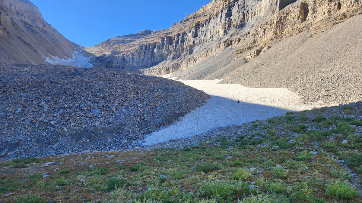
Most of the tens of thousands of hikers that trek up Utah’s Mount Timpanogos each year have no idea that the rockfall below them conceals an enormous glacier. And beyond the people who study them, knowledge that glaciers like these, called rock glaciers, even exist in Utah is not widespread, said Michael Thorne, a seismologist at the University of Utah. But that’s what Timpanogos Glacier is: a glacier concealed by layers of fallen rock that contains rock debris. Its ice is internal, which is why so many Utah recreationists barely know it’s there. Though it’s hidden, the glacier contains an enormous amount of ice: 1,550,000 cubic meters, or enough to fill Egypt’s largest pyramid, according to a new study published in the Journal of Geophysical Research: Earth Surface. The study provides a detailed 3D map of the rock glacier using a new approach and is an important step toward a better understanding of rock glaciers in Utah and beyond, said Doug Clark, a geologist at Western Washington University who was not involved in the study but researches rock glaciers in the western United States and New Zealand. The study takes “an elegant approach to address one of the more vexing problems regarding rock glaciers: What is the internal ice content of these things?” Clark said. Defining Gravity “Can we come up with techniques for imaging the interior of these rock glaciers that don’t only rely on ground-penetrating radar?” To measure regular glaciers and to know how much water they contain, scientists usually use ground-penetrating radar (GPR), which travels easily through ice. But the method doesn’t work as well with rock glaciers. GPR can’t always detect the bedrock beneath the glacier because it can’t penetrate the rock layer above it, so the method can’t always tell how thick a rock glacier really is. “Part of our motivation has been, well, ‘Can we come up with techniques for imaging the interior of these rock glaciers that don’t only rely on ground-penetrating radar?’” said Thorne, who is also a coauthor of the new study. While teaching an undergraduate geology lab class, he had an idea: Could the research team use a gravimeter instead? Because Earth’s surface and interior (and therefore mass) change very slightly depending on where on the planet you are, its gravity changes slightly, too. Over very dense bedrock, for example, you weigh slightly more than you would standing above a vast underground cave. A gravimeter measures these tiny changes in gravity and can therefore tell scientists the differences in density of underground material—such as the difference between rock and ice. Some hikers might assume Timpanogos Rock Glacier is visible from the trail, but that’s just last winter’s snow. The glacier itself is hidden beneath a layer of loose rock. Credit: Robben Migacz, Michael Thorne “As we get to areas where the ice is thicker and thicker, the gravitational acceleration is just lower and lower,” Thorne said. Gravimeters were used previously to measure glaciers, but the method fell out of favor when GPR was developed. In addition, the gravimeters of today are more sensitive and accurate than ever before, allowing scientists to measure “really small deviations in the gravitational field,” said Leif Andersson, a glaciologist at the University of Utah and a coauthor of the new study. “The reason why the study was possible was the technology.” University of Utah master’s student and ultrarunner Bronson Cvijanovich carried the gravimeter up a 5-mile high-elevation trail, taking 232 gravimeter measurements over the course of six multiday trips to Timpanogos Glacier. Then, the team analyzed the data using a statistical method called Bayesian inversion, which compares thousands of predictions from simulations of the distribution of ice beneath the surface to real measurements of the glacier, giving researchers a measure of how well their data fit reality. Cvijanovich and the gravimeter, which made imaging the rock glacier possible. Credit: Bronson Cvijanovich According to Clark, the modeling in the study and the use of the gravimeter marked a “significant improvement over past efforts of estimating ice volume” in rock glaciers. Using this method, along with some measurements of other rock glaciers, the researchers determined a relationship between the surface area of a rock glacier and the typical volume of ice beneath it. They estimated that Timpanogos Glacier contains enough ice to fill about 600 Olympic swimming pools with an equivalent amount of water. “It’s a huge volume of ice—I’m surprised there is that much,” Anderson said. Expanding their analysis, the researchers estimated that rock glaciers in the state of Utah hold about 1.08 cubic kilometers of ice, rock glaciers across the western United States hold up to about 13 cubic kilometers of ice, and all the known rock glaciers on Earth store about 52.38 cubic kilometers of ice. (For reference, the Antarctic Ice Sheet contains about 30 million cubic kilometers of ice.) The Role of Rock Glaciers Rock glaciers are a unique source of water, Thorne said, because they release water year-round, including at the end of summer when other water stores have been depleted. The layer of rock above them also insulates them from heat, making them more resilient in warming weather. Plus, they can act as environmental refuges for plants and wildlife (such as the American pika) because they provide a relatively cooler habitat. Understanding how much ice rock glaciers store is the first step in understanding how they might melt in the future, too. The new study also opens an opportunity to start investigating the extent to which Utah’s rock glaciers contribute to the state’s water systems—they’re unaccounted for in the state’s hydrological models, meaning scientists don’t have the full picture of how their meltwater affects the rest of the state. “They represent these unrecognized ice reservoirs and water reservoirs,” Clark said. “They’re a unique and particularly resilient resource compared to other glaciers that are melting quite rapidly.” Timpanogos Rock Glacier and Emerald Lake below it are visible from the summit of Mount Timpanogos. Credit: Michael Thorne “If all that ice is stored, is it still growing? How much of it is melting and adding to the downstream hydrology? We don’t know that yet,” Anderson said. He added that it’s difficult to measure how much of the water coming off a rock glacier is from the glacier melt versus groundwater, but doing so would help to answer some of the outstanding questions about rock glaciers in Utah. “I think this can open a new direction in the study of buried ice globally.” He hopes other researchers apply the gravimeter and Bayesian analysis method elsewhere to see just how much ice is locked away in the world’s rock glaciers. “I think this can open a new direction in the study of buried ice globally,” he said. Clark agreed. “It would be great for some other folks to replicate this with a few other rock glaciers, and for a wider variety of rock glaciers,” he said. “That would be an important test of [the data] they’ve got here.” —Grace van Deelen (@gvd.bsky.social), Staff Writer Citation: van Deelen, G. (2026), Scientists mapped a hidden glacier using gravity, Eos, 107, https://doi.org/10.1029/2026EO260297. Published on 17 September 2026. Text © 2026. AGU. CC BY-NC-ND 3.0Except where otherwise noted, images are subject to copyright. Any reuse without express permission from the copyright owner is prohibited.
Scientists Mapped a Hidden Glacier Using Gravity
Full Article
Original Source
Read the full article at Eos →KhanList aggregates and links to publicly available news content. We do not host full articles from third-party sources. Always verify important information with original sources.