
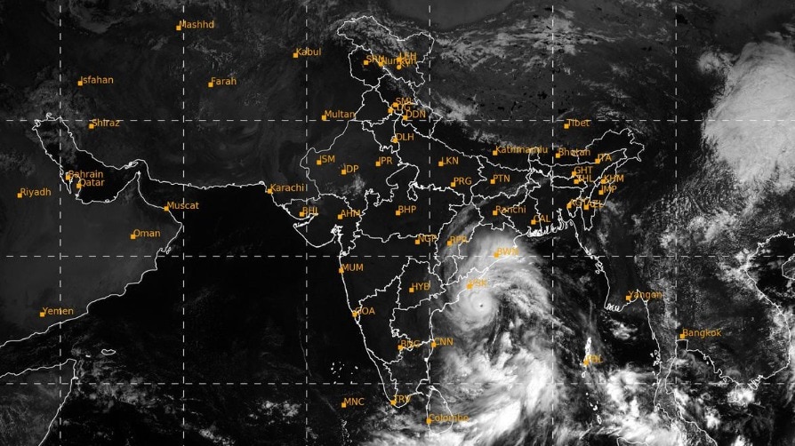
Satellite images show Cyclone Arnab swirling over the Bay of Bengal, with intense thunderstorm activity surrounding the storm as it moves towards India's eastern coast.The system has intensified into a very severe cyclonic storm, prompting the India Meteorological Department (IMD) to issue a red alert for Andhra Pradesh and Odisha. A satellite image captures Cyclone Arnab. (Photo: Windy) The latest IMD bulletin based on Tuesday, October 27, placed Arnab over the west-central Bay of Bengal, around 220 km south-southeast of Visakhapatnam and 240 km east-southeast of Kakinada in Andhra Pradesh.WHAT DO SATELLITE IMAGES SHOW?The IMD's latest satellite bulletin, based on imagery from India's INSAT-3DS weather satellite, placed the storm's centre near 16.0°N latitude and 84.4°E longitude. It reported intense to very intense thunderstorm activity over the north-western and southern Bay of Bengal, north coastal Andhra Pradesh and Odisha. These cloud patterns form as warm, moist air rises and fuels thunderstorms around a cyclone.Satellite images help meteorologists track the storm's position and the development of its cloud systems over the sea, where direct observations are limited. They provide an important picture of how the system is organised as it approaches land.WHEN AND WHERE WILL ARNAB MAKE LANDFALL? According to the latest IMD forecast, Arnab is likely to continue moving west-northwestwards until Tuesday evening before turning northwestwards towards the coast.It is expected to cross the Andhra Pradesh and Yanam coasts between Bapatla and Visakhapatnam, close to Yanam, by the forenoon of Wednesday, October 28.The Arnab effect that started in the coastal region.. #Arnab #ArnabCyclone #AP #AndhraPradeshNews https://t.co/zm9xzJezSx— Suresh Elangovan (@sureshelangov12) October 27, 2026At landfall, the very severe cyclonic storm is forecast to pack maximum sustained wind speeds of 125-135 kmph, with gusts reaching 150 kmph.WHAT LIES AHEAD?Heavy rain and powerful winds are key concerns as Arnab approaches the coast. The storm's exact impact will depend on its track and strength when it makes landfall.The IMD's message signals a serious cyclone threat along the affected coastline. With the system moving closer to land, updated weather bulletins will be crucial for tracking changes in its position, intensity and expected impacts.- Ends
Satellites capture Cyclone Arnab churning in Bay of Bengal. What's ahead?
Full Article
Original Source
Read the full article at Indiatoday →KhanList aggregates and links to publicly available news content. We do not host full articles from third-party sources. Always verify important information with original sources.