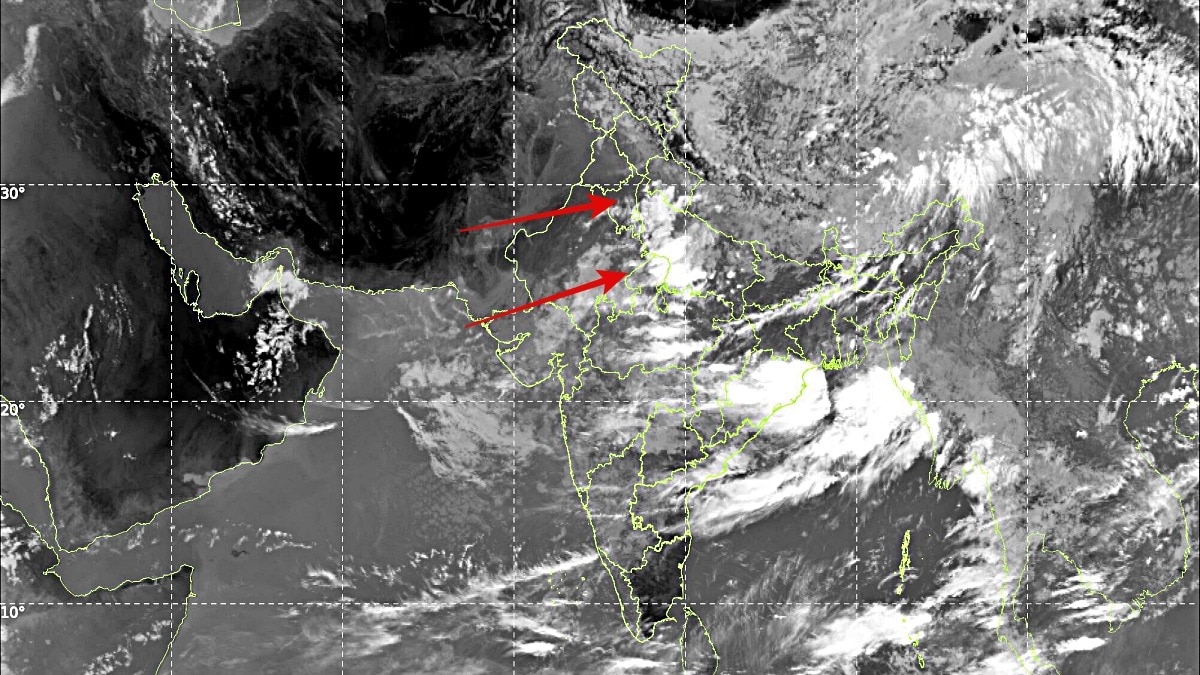
Satellite imagery shows the monsoon axis pulling away from Delhi as dry northwesterly winds spread across northwest India. The shift is set to bring a short spell of lower humidity before rain chances return later this week.Bulk of monsoon cloud activity concentrated over eastern and central India. (Photo: IMD)After days of humid and uncomfortable weather, residents of Delhi-NCR, Punjab and Haryana are finally set to experience some relief as dry northwesterly winds have begun sweeping across northwest India.The change comes as the monsoon trough, or monsoon axis, shifts closer to the foothills of the Himalayas, altering rainfall patterns across northern India.Latest satellite imagery from INSAT-3DS on August 16 shows the bulk of monsoon cloud activity concentrated over eastern and central India, extending from eastern Uttar Pradesh through Bihar and into the Bay of Bengal.In contrast, large parts of Punjab, Haryana and Delhi-NCR remain under relatively cloud-free conditions. According to weather analysts, sustained northwesterly winds exceeding 10 kmph are transporting drier air into the region. While daytime temperatures may not witness a dramatic drop, the reduction in moisture content is expected to significantly lower humidity levels and improve comfort conditions. The real-feel temperature is likely to reduce as dry winds replace the moisture-laden monsoon flow, and the next two days are expected to remain largely dry.Apart from isolated evening showers in a few pockets, no widespread rainfall activity is anticipated across Delhi-NCR, Punjab and Haryana through August 17.The shift in the monsoon axis towards the Himalayan foothills is also likely to enhance rainfall over parts of Himachal Pradesh, Uttarakhand and adjoining foothill regions.However, the dry spell is not expected to last long.Weather models indicate that conditions could begin changing again between August 18 and August 20 as a low-pressure area moves inland from the Bay of Bengal. The system is expected to interact with the monsoon trough, causing it to oscillate southward once again.As a result, rainfall activity may gradually return to northwest India later in the week and into the weekend. The developing low-pressure area is also expected to keep heavy rain concentrated over eastern and central Uttar Pradesh, Bihar, Jharkhand, Madhya Pradesh and surrounding regions over the next few days.For now, though, Delhi and its neighbouring states can look forward to a brief break from sticky monsoon conditions, with clearer skies, lower humidity and more comfortable weather dominating the region.- EndsPublished By: Sibu Kumar TripathiPublished On: Aug 16, 2026 12:21 IST
Satellite spots monsoon pulling back from Delhi, rain belt shifting
Full Article
Original Source
Read the full article at Indiatoday →KhanList aggregates and links to publicly available news content. We do not host full articles from third-party sources. Always verify important information with original sources.