
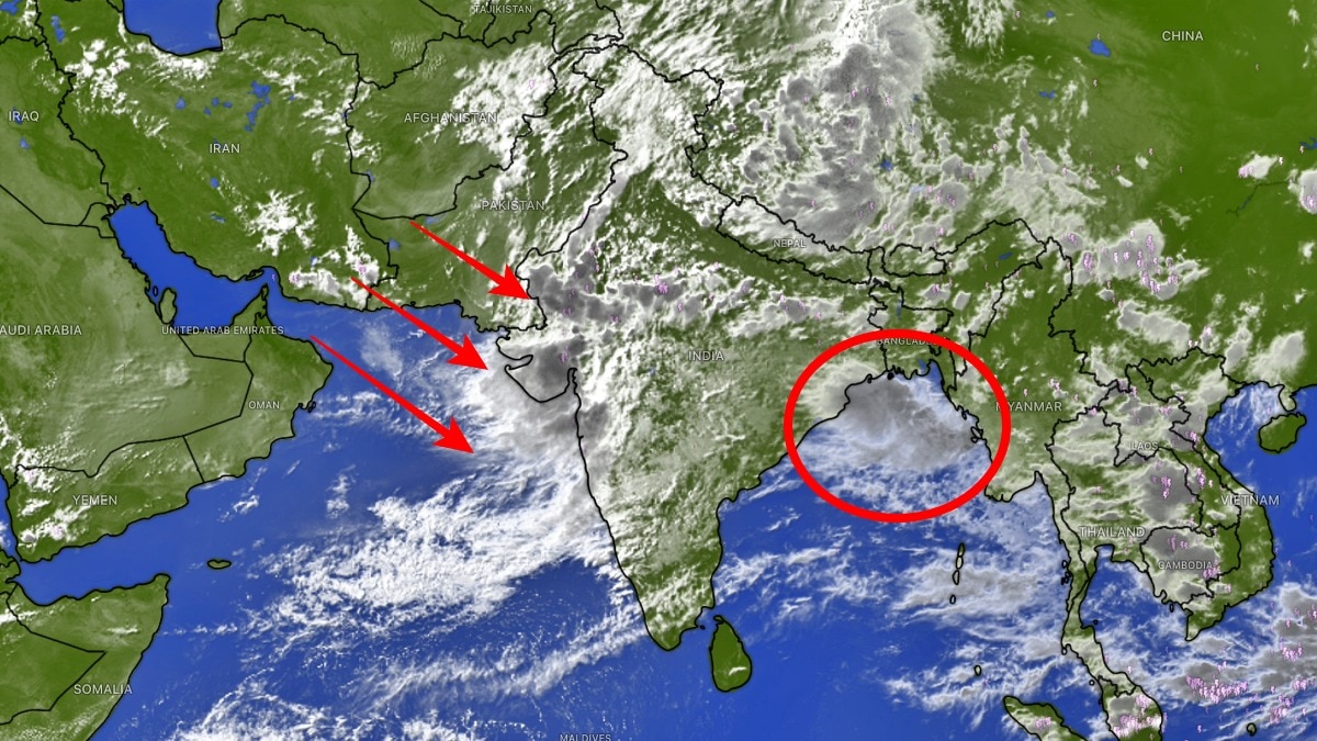
INSAT-3DR imagery shows the Arabian Sea and Bay of Bengal simultaneously fuelling an intense monsoon spell over India. The pattern has put Gujarat and nearby regions on alert for flooding, disruptions and possible evacuations.Satellite image shows monsoon systems active on both sides of India pumping rain. (Photo: Windy)The southwest monsoon is showing no signs of slowing down, with the latest INSAT-3DR satellite imagery revealing massive cloud bands stretching across western and eastern India as the Arabian Sea and the Bay of Bengal simultaneously fuel intense weather systems.Meteorologists have warned that the next 36 to 48 hours will be critical, particularly for Gujarat, south Rajasthan and northwest Maharashtra, where extremely heavy rainfall could trigger fresh flooding in several districts.The satellite images show dense convective cloud masses covering much of Gujarat and adjoining parts of Rajasthan, while another expansive cloud shield continues to dominate the Bay of Bengal and eastern India.Moisture streaming in from both seas has created an ideal environment for widespread thunderstorms and torrential rain over western India. According to the latest forecast from the European Centre for Medium-Range Weather Forecasts (ECMWF), rainfall is expected to intensify further over Gujarat during the next two days. Weather experts have advised residents and authorities to remain on high alert as some locations could receive 300 mm to 700 mm of rainfall over the next 48 hours.After heavy flooding affected Valsad and Vapi, the focus is now shifting towards Ahmedabad, Vadodara, Surat, Anand, Bharuch, Himmatnagar, Palanpur and Pratapgarh, where rapidly rising water levels and urban flooding are becoming a growing concern.The India Meteorological Department has already warned of heavy to extremely heavy rainfall over parts of Gujarat, south Rajasthan and northwest Maharashtra through the next 36 to 48 hours as the monsoon circulation remains active over western India.Forecasters say the current weather pattern is being sustained by abundant moisture from the Arabian Sea, while a strong monsoon trough and favourable upper-air conditions continue to enhance cloud formation.At the same time, vigorous convection over the Bay of Bengal indicates that eastern India will also continue to witness widespread rainfall.The combination of active weather systems over both seas is expected to keep the monsoon vigorous across large parts of the country, with intense thunderstorms, lightning, squally winds and prolonged heavy rain likely in several regions.Authorities in Gujarat have urged residents in low-lying areas to remain vigilant as rivers and reservoirs continue to swell following consecutive days of heavy rainfall.Urban flooding, waterlogging, traffic disruptions and possible evacuations cannot be ruled out if the forecast rainfall materialises.While the widespread rains are expected to provide a significant boost to seasonal rainfall totals, the immediate concern remains the risk of flash floods, overflowing rivers and damage to infrastructure.With both the Arabian Sea and the Bay of Bengal actively feeding moisture into the monsoon system, satellite imagery suggests that one of the season's most intense rainfall spells is still unfolding, leaving western India on alert for another 48 hours.- EndsPublished By: Sibu Kumar TripathiPublished On: Jul 24, 2026 07:00 IST
Satellite spots Arabian Sea, Bay of Bengal churning monsoon mayhem at once
Full Article
Original Source
Read the full article at Indiatoday →KhanList aggregates and links to publicly available news content. We do not host full articles from third-party sources. Always verify important information with original sources.