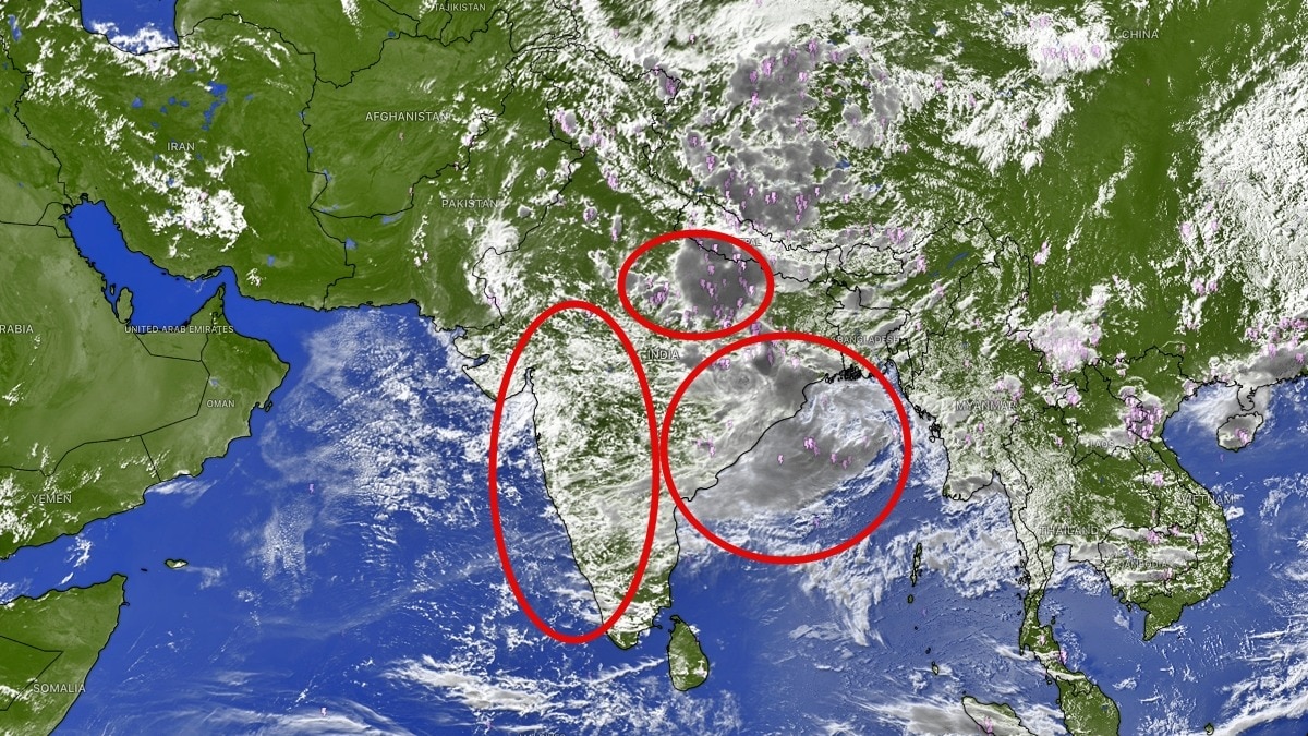
Satellite images have shown dense monsoon cloud bands spreading across India as a Bay of Bengal low moves inland. The system is expected to drive heavy rain across eastern and central states in the coming days.The most intense cloud clusters are concentrated over the northern Bay of Bengal, eastern India. (Photo: Windy)India's monsoon appears to be gathering fresh momentum, with satellite imagery showing vast swathes of the country covered under thick cloud bands as a new low-pressure system over the Bay of Bengal begins influencing weather across eastern and central regions.Images from EUMETSAT and ISRO's INSAT-3D/3DR satellites on August 13 reveal an extensive cloud shield stretching from the Arabian Sea across central India into the Gangetic plains and the Northeast.The most intense cloud clusters are concentrated over the northern Bay of Bengal, eastern India, Bangladesh and adjoining regions, where the newly formed low-pressure area is drawing moisture inland. The India Meteorological Department (IMD) said a low-pressure area has formed over the north Bay of Bengal off the West Bengal-Bangladesh coast. The system is expected to move inland and sustain widespread rainfall activity over Odisha, West Bengal, Jharkhand, Chhattisgarh and adjoining states over the next several days.The satellite images show deep convective clouds with cold cloud tops over eastern India, a signature of vigorous thunderstorm activity and heavy rainfall. Large cloud masses are also visible over Uttar Pradesh, Bihar, Madhya Pradesh and parts of the Northeast, indicating that the monsoon trough remains active across the subcontinent.Weather officials have warned of heavy to very heavy rainfall in several states as the system interacts with the monsoon flow. Odisha remains under particular watch, while parts of eastern and central India could see intense downpours capable of triggering local flooding and waterlogging.The fresh Bay of Bengal system comes at an important time for the monsoon season. August rainfall has remained uneven across parts of the country, and forecasters are closely tracking whether successive low-pressure systems can offset the impact of the developing El Nino conditions.For now, the view from space suggests the monsoon engine is very much alive.With dense cloud cover stretching across much of India and a new rain-bearing system moving inland, the second half of August could bring a significant boost to rainfall over eastern, central and northern parts of the country.- EndsPublished By: Sibu Kumar TripathiPublished On: Aug 13, 2026 15:55 IST
Satellite captures India shrouded in rain clouds, monsoon gaining momentum
Full Article
Original Source
Read the full article at Indiatoday →KhanList aggregates and links to publicly available news content. We do not host full articles from third-party sources. Always verify important information with original sources.