
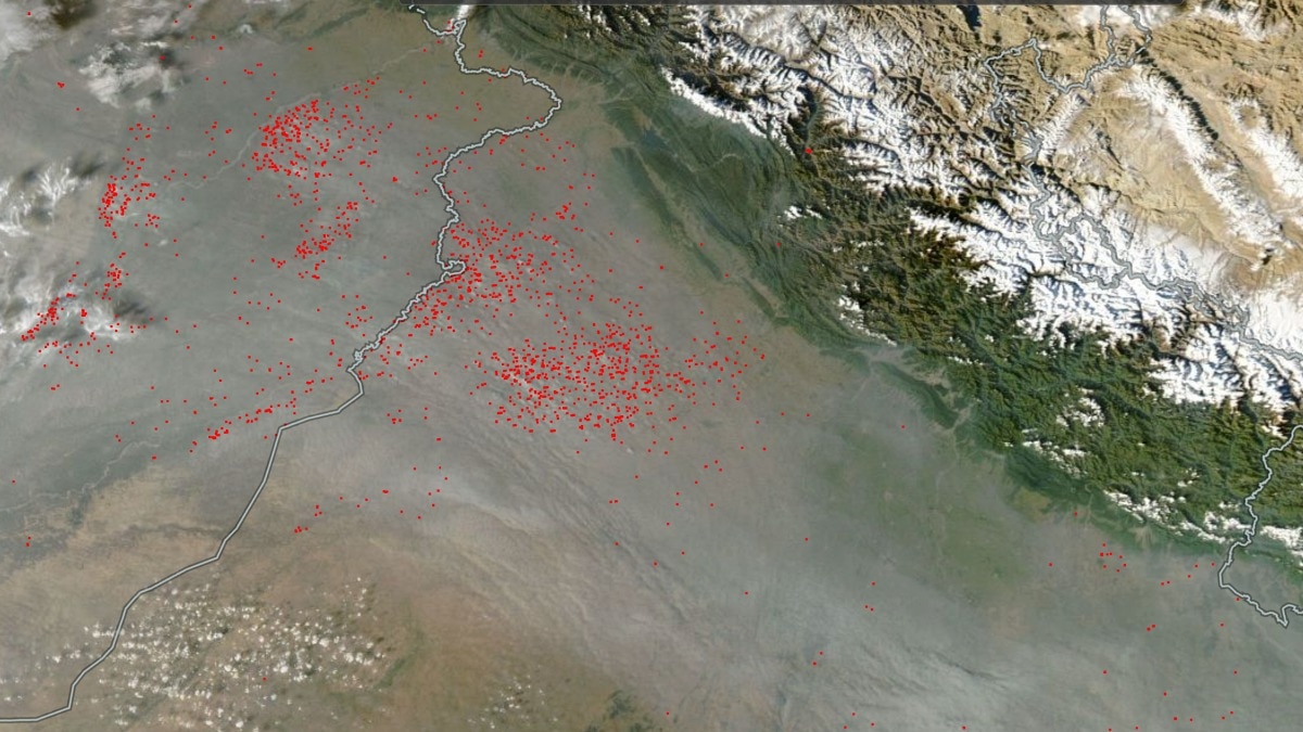
Nasa imagery has revealed widespread farm fires and smoke across the India-Pakistan border. Sluggish northwesterly winds are trapping pollutants and worsening Delhi-NCR's air quality.The satellite map shows hundreds of red hotspots concentrated across the agricultural belt on both sides of the India-Pakistan border. (Photo: Nasa)New Delhi,Nov 4, 2026 13:19 ISTNasa satellite imagery has captured widespread farm fires across Pakistan, Punjab and Haryana, as stubble burning and sluggish northwesterly winds fuel a thick blanket of smog over the northern plains, pushing Delhi's air quality to some of its worst levels this season.Data from Nasa's Fire Information for Resource Management System (FIRMS), showing fire detections over the past 24 hours on November 4, reveals clusters of active fire hotspots across Pakistan's Punjab region, Indian Punjab and parts of Haryana.The satellite map shows hundreds of red hotspots concentrated across the agricultural belt on both sides of the India-Pakistan border. Several clusters are visible across west-central Punjab, north and central Haryana, with additional detections further west.The fire activity comes at a critical time for Delhi-NCR, where air quality has deteriorated sharply as smoke from agricultural fires combines with other pollution sources and gets trapped over the region. NORTHWESTERLY WINDS PUSH SMOKE TOWARDS DELHIMeteorologists say the slow movement of northwesterly winds has allowed smoke from farm fires across Pakistan and Punjab, along with parts of northern Haryana, to accumulate over the northern plains.Areas across west-central Punjab, north and central Haryana, and western Uttar Pradesh are particularly exposed to the smog plume because of their alignment with the prevailing wind direction. The situation has also worsened across Delhi-NCR, where air quality monitoring stations have recorded AQI readings ranging between 300 and 500. The concentration of smoke could shift further towards the national capital as wind patterns continue to transport pollution. (Photo: PTI) The concentration of smoke could shift further towards the national capital as wind patterns continue to transport pollution from the northwest.No major improvement in air quality is expected in the immediate term, with meteorological conditions currently offering limited scope for the dispersal of pollutants.SATELLITE DATA HIGHLIGHTS REGIONAL POLLUTION CRISISThe Nasa FIRMS imagery provides a snapshot of the widespread fire activity contributing to the seasonal pollution crisis across northern India.However, individual hotspots represent satellite-detected thermal anomalies and do not independently establish the size of a fire or quantify its contribution to Delhi's pollution.With smoke accumulating over the region, residents have been advised to limit prolonged outdoor exposure, particularly during periods of poor air quality. Wearing well-fitted masks when stepping outdoors and avoiding strenuous physical activity outside can help reduce exposure to polluted air.The latest satellite observations underline how agricultural fires across national borders, combined with unfavourable weather conditions, can intensify the air pollution crisis across the Indo-Gangetic plains.- Ends
Satellite captures farm fires across India, Pakistan; thick smog over Delhi
Full Article
Original Source
Read the full article at Indiatoday →KhanList aggregates and links to publicly available news content. We do not host full articles from third-party sources. Always verify important information with original sources.