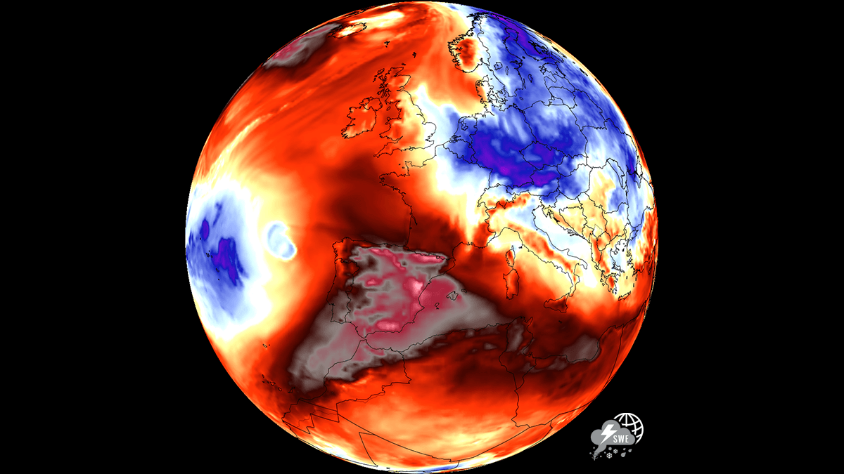
An unforgiving atmospheric furnace is setting its sights on the Iberian Peninsula, with an excessive heatwave threatening to push temperatures into a staggering and potentially record-shattering 45 to 47 °C range this week. As a stubborn heat dome of high pressure anchors itself over southwestern Europe, Spain is bracing for what meteorologists warn could be one of the most intense and dangerous early-summer thermal anomalies in recent history. The upcoming heat is not merely a standard summer warm-up; it represents an extreme surge of superheated air drawing directly from the Sahara Desert as a new Heat Dome establishes itself in Southwest Europe. Communities from Andalusia down to the interior plains are preparing for extreme conditions where daytime highs will push human endurance and local infrastructure to their absolute limits. Nighttime relief will be virtually nonexistent, with overnight lows remaining in the mid- to upper 20s, compounding physiological stress for millions of residents. The primary driver of this extreme event is a robust atmospheric blocking pattern featuring an expansive upper-level ridge, a classic heat dome anchored directly over Southwestern Europe. Reinforced by a cut-off low-pressure system to its west, this synoptic setup pumps an exceptionally hot, dry air mass straight from the Sahara Desert across the Iberian Peninsula. A classic warm plume, but with potentially more than 30 °C at the 850 mbar level. Localized terrain dynamics will play a crucial role in pushing the near-surface temperatures toward the 47 °C threshold. As the synoptic winds sweep across the peninsula, localized downslope (foehn) effects over the interior plateaus and mountain ranges will force air masses to descend rapidly towards eastern and southern plains. This rapid compression causes adiabatic warming, stripping the air of any remaining moisture and supercharging the heat. This dynamic explains why the southern and eastern Spanish plains, particularly the Guadalquivir and Ebro valleys, alongside regions like Murcia and Castilla-La Mancha, frequently record the most extreme, near-record spikes. The upcoming days might challenge some historic records in these regions. Historic records for the region The Spanish highest temperatures recorded from the previous heatwaves are the following: 47.6 °C – Guadalquivir basin (Spain national record) in La Rambla, Córdoba on 14th August, 2021 47.0 °C – Murcia Region at the Alcantarilla Air Base on 15th August, 2021 45.5 °C – Castilla-La Mancha in Talavera de la Reina on 14th August, 2021 44.5 °C – Ebro Valley at Zaragoza Airport on 7th July, 2015 The Spanish record holder, 47.6 °C at La Rambla, was officially validated by AEMET. La Rambla lies in the Córdoba countryside within the Guadalquivir basin, slightly away from the immediate river floor. On the same day, Montoro reached 47.4 °C while Córdoba Airport recorded the peak temperature of 46.9 °C. The European record is 48.8 °C observed in Syracuse, Sicily, Italy on 11th August, 2021. It was verified by the World Meteorological Organization (WMO). The previous European record was 48.0 °C at Athens and Elefsina, Greece, on 10th July 1977. So Spain’s 47.6 °C record is just 1.2 °C below the European record. According to the weather model guidance this week, Murcia is probably the most interesting record-threat zone, while the Ebro Valley could get remarkably close to its own regional record. Some additional notes: The modern official benchmark is 47.0 °C at Alcantarilla Air Base from 15th August, 2021, while Murcia city itself reached 46.2 °C that day. The highest value in the Castilla-La Mancha region is 45.5 °C at Talavera de la Reina on 14th August 2021. On that same afternoon, some other stations also peaked very high. Almadén reached 45.4 °C, Puertollano reached 45.0 °C, and Puebla de Don Rodrigo reached 44.8 °C. Those figures are from AEMET observations during the historic heatwave of August 2021. The Ebro Valley peak remains 44.5 °C at Zaragoza Airport on 7th July 2015. Regional Impacts and Severe Risks The consequences of this prolonged thermal peak extend far beyond simple discomfort, threatening key regional sectors: Wildfire Explosions: Parched landscapes, combined with low humidity driven by downslope winds and the possibility of dry lightning storms, have pushed wildfire danger to extreme, maximum levels across multiple regions. Agricultural and Infrastructure Strain: Crops face severe thermal stress, while water reservoirs experience accelerated evaporation. Energy grids are also heavily tested by the demands of continuous cooling. Tropical Nights: Urban centers and southern lowlands will see overnight temperatures fail to drop below 25 °C, denying residents critical physiological relief and elevating health risks. The driving force behind this pattern is similar to the one faced over much of Europe recently: a strengthening upper-level ridge building out of the Sahara Desert, Northwest Africa, and expanding a major warm plume across western and central Europe. Before we dig into the details about the pattern evolution in Europe, lets examine what is the main driver behind these extensive warm waves and heatwaves in general. What is a Heat Dome? When significant, record-breaking heatwaves occurred in Europe, the United States, and Canada in the past, the Heat Dome was a contributing factor. The heat dome is usually the dominant feature of summer weather patterns on both continents. We refer to this phenomenon as a heat dome when extremely high temperatures develop. Here’s how it works and why understanding it on a broader scale is essential. The upper-level ridge pattern, or very warm air mass in the higher altitudes, also known as the Upper High (or blocking High), usually forms the heat dome. This weather pattern brings high, and sometimes record-breaking, temperatures to the region below. This term is used when a broad area of high-pressure air parks over a large portion of the continent. If the event is remarkably stable and extreme, it usually lasts several days or weeks. The heat dome works like a lid on a pot. The dome traps warm air at all levels beneath it, with layers sinking toward the ground. As a result, the air mass becomes anomalously warm at the lowest elevations and extremely hot near the surface. How does a heat dome affect life beneath it? Excessive heat in heat domes can significantly impact human health and be dangerous to particularly vulnerable populations, such as elderly individuals, children, and those with pre-existing health conditions that can be worsened by extreme heat. Due to prolonged exposure to high temperatures, construction workers, farmers, and other long-hour outdoor workers are at increased risk of heat-related illnesses. People living in poverty are also more susceptible to the fatalities of heat domes, as their houses are often built with heat-trapping surfaces such as concrete and asbestos. Heat exhaustion occurs with prolonged exposure to high temperatures. It leads to dehydration, dizziness, and, in more severe cases, heat stroke. High relative humidity during a heatwave can also significantly affect the body. For this reason, we use the Heat Index to represent the perceived feel of scorching-hot temperatures and high humidity. It illustrates the natural relationship between temperature and humidity. A new, powerful Omega Block with Heat Dome expands into southwestern Europe By midweek, a new upper-level ridge expands from northwestern Africa, where an extremely hot air mass has been advected from the Sahara Desert in recent days. Algeria and Tunisia have reported up to 49 °C on Monday. Over the weekend, Sardinia Island, Italy, recorded more than 47 °C at the nose of this warm plume into the southern Mediterranean. An astonishing 47.8 °C was reported from Santa Lucia-Uta, 47.3 °C in Muravera, 47.2 °C in Ollastra, and 47.1 °C in Orani, Villa Verde, and Uta-Macchiareddu. As the new week starts, the blocking High retrogrades westward, into the Iberian Peninsula, thus creating the conditions for an excessive heatwave to strengthen again. To the east, a cold wave is racing south across Eastern Europe as we discussed in our recent article. Over the Atlantic, an intense ridge remains, expanded from the Azores towards the north and partly over Western Europe. The surface response of the powerful Azores high raises sea-level pressure over western and southwestern Europe, while lower pressure persists further east, associated with the southwards-moving trough. This supports the general northerly and westerly near-surface flow over the Iberian Peninsula, pushing air masses from the higher terrain over the central peninsula into the lowlands of south and east Spain. The regions that often experience the most intense heat during heatwaves. Under the strengthening ridge, temperatures will become extreme over Iberia, especially south, central and eastern Spain. Temperatures at the 850 mbar level are forecast to push into the 30-31 °C, which is particularly extreme also for this part of Europe. This means temperatures in the lowest levels will be 10-15 °C above normal for late July, leading to excessive heat for the surface. This rarely occurs over southwestern Europe, mostly during near-record-challenging Heat Domes. As we see on the chart above, the most anomalous temperatures are seen over the eastern and southern regions, where the lowlands are. This happens because extremely dry air passes over the region, resulting in strong downslope winds from the higher terrain of the central peninsula. Such arid conditions then allow temperatures to climb extremely high. Peak daytime highs could push well above 45 °C, challenging some historic local records The heatwave rapidly intensifies by mid-week as the ridge expands and parks its axis over southwestern Europe. We are posting the side-by-side comparison of the global GFS model and the regional ARPEGE model forecasts. On Wednesday, GFS predicts 42-44 °C from central Spain to the southern lowlands; similar forecasts are seen by the ARPEGE model. The rest of Spain and Portugal should expect 34 to 40 °C peak afternoon temperatures. By Thursday, the air mass warms further over the Iberian Peninsula, pushing peak temperatures much higher across the region. Central Spain will climb into the low 40s per GFS and ARPEGE, while eastern and southern lowlands will push into 44-46 °C. Some local valleys could see temperatures even above 46 °C, to near 47 °C, in the peak afternoon temperatures, as a dry air mass allows temperatures to rise even higher with the dry downslope westerly winds. This is most likely over Murcia, Alicante and Valencia provinces. A much hotter day is also forecast for the Ebro Valley, with peaks into the 43-44 °C range. A hot air mass will push into southern France as well, where upper 30s are expected again on Thursday. Another extremely hot day and also the last in this short but intense heatwave will be on Friday, with the same areas hit with the excessive heat. Southern and eastern lowlands and the Ebro Valley should push to near 45 °C again. Areas further west will begin feeling the more humid air mass from the Atlantic; thus, some refreshment will follow, and temperatures should stay below 40 °C there on Friday. Portugal will be even lower, from the upper 20s to the low 30s, compared to days before. Note that this heatwave, combined with moderately strong and very dry winds, will further support an ongoing extreme fire risk over the whole peninsula. New wildfires may ignite and spread rapidly in these conditions, as very low relative humidity and high winds become supportive of explosive wildfires. We will be monitoring the ongoing development of the potential further spread of the Heat Dome back into Western and Central Europe towards the end of July. We will update the forecasts accordingly as the situation evolves next weekend. Stay tuned. Stay tuned for updates. Wxcharts, PivotalWeather, and Meteociel provided images used in this article. See also: Dramatic Cold Wave Breaks Extreme Heat Across Central Europe and The Balkans
Sahara Heat Dome and dry winds Threaten Spain With Historic 44-47 °C Highs
Full Article
Original Source
Read the full article at Severe-weather →KhanList aggregates and links to publicly available news content. We do not host full articles from third-party sources. Always verify important information with original sources.