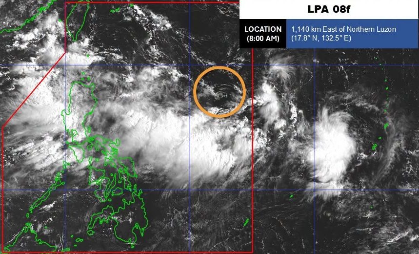
LPA. Satellite image of the low pressure area as of August 17, 2026, 8 am. PAGASA In its 11 am advisory on Monday, August 17, PAGASA expands the list of areas seeing significant rainfall due to the southwest monsoon Areas on the western side of Luzon are most affected by rain from the southwest monsoon on Monday, August 17. PAGASA is monitoring a low pressure area that is now inside the Philippine Area of Responsibility. This is AI-generated. Read the article for full context. Report any errors. MANILA, Philippines – The weather bureau now expects up to intense rain from the southwest monsoon or habagat in the coming hours and days, based on its rainfall outlook released at 11 am on Monday, August 17. The Philippine Atmospheric, Geophysical, and Astronomical Services Administration (PAGASA) also expanded the list of areas seeing significant rainfall due to the southwest monsoon in the next 72 hours. Monday noon, August 17, to Tuesday noon, August 18 Heavy to intense rain (100-200 millimeters): Benguet, La Union, Pangasinan, Zambales, Bataan Moderate to heavy rain (50-100 mm): Ilocos Sur, Abra, Tarlac, Pampanga, Bulacan, Metro Manila, Rizal, Cavite, Batangas, Occidental Mindoro Tuesday noon, August 18, to Wednesday noon, August 19 Heavy to intense rain (100-200 mm): Benguet, La Union, Pangasinan, Zambales, Bataan, Occidental Mindoro Moderate to heavy rain (50-100 mm): Ilocos Sur, Tarlac, Pampanga, Bulacan, Metro Manila, Cavite, Batangas, Rizal, Laguna, Antique Wednesday noon, August 19, to Thursday noon, August 20 Heavy to intense rain (100-200 mm): Zambales, Bataan, Occidental Mindoro Moderate to heavy rain (50-100 mm): Ilocos Sur, La Union, Benguet, Pangasinan, Tarlac, Pampanga, Bulacan, Metro Manila, Rizal, Cavite, Laguna, Batangas Other areas in Luzon and Western Visayas not mentioned above may have isolated to scattered rain showers and thunderstorms on Monday, still because of the southwest monsoon. PAGASA reminded Luzon and Western Visayas to watch out for floods and landslides, especially areas with moderate to intense rain. Meanwhile, one of the two low pressure areas (LPAs) that PAGASA was watching — located outside the Philippine Area of Responsibility (PAR) — already left the weather bureau’s monitoring domain at 2 am on Monday. But the other LPA, which formed on Sunday, August 16, has since entered PAR. By 8 am on Monday, it was located 1,140 kilometers east of Northern Luzon. PAGASA Weather Specialist Aldczar Aurelio said early Monday that the LPA is moving generally westward toward extreme Northern Luzon. At the moment, the LPA has a medium chance of developing into a tropical depression within 24 hours. If it does, it would be given the local name Neneng. PAGASA expects up to four tropical cyclones to develop within or enter PAR in August. There have already been two during the month — Tropical Depression Luis and Tropical Storm Maymay (Kujira). The southwest monsoon, Luis, and Maymay combined have left at least 23 people dead, 17 injured, and one missing, according to the National Disaster Risk Reduction and Management Council (NDRRMC). The bad weather in August has affected nearly 5 million people or 1.43 million families across 10 regions, based on NDRRMC data. So far, the estimated cost of damage to infrastructure is pegged at P3.4 billion, while the estimated cost of damage to agriculture is over P689 million. – Rappler.com How does this make you feel? Loading
Rain from southwest monsoon to reach intense level again; LPA enters PAR
Full Article
Original Source
Read the full article at Rappler →KhanList aggregates and links to publicly available news content. We do not host full articles from third-party sources. Always verify important information with original sources.