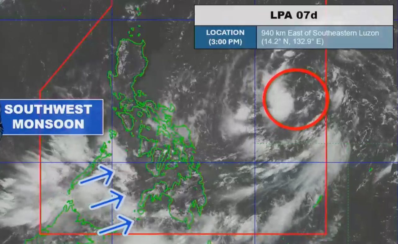
LPA. Satellite image of the low pressure area as of July 22, 2026, 3 pm. PAGASA The low pressure area expected to become Tropical Depression Kiyapo is last spotted 940 kilometers east of southeastern Luzon on Wednesday afternoon, July 22 MANILA, Philippines – The weather bureau warned the public to brace for significant rainfall from the potential tropical cyclone inside the Philippine Area of Responsibility (PAR) and the southwest monsoon or habagat during the week. The potential tropical cyclone is the low pressure area (LPA) being monitored, which entered PAR at 7 am on Wednesday, July 22. The LPA still has a high chance of developing into a tropical depression. Once it does, it will be given the local name Kiyapo — the Filipino word for water cabbage or water lettuce. Manila’s Quiapo district got its name from this plant. The potential Kiyapo would be the Philippines’ 11th tropical cyclone for 2026, and the fourth for July. The Philippine Atmospheric, Geophysical, and Astronomical Services Administration (PAGASA) said the LPA was last spotted 940 kilometers east of southeastern Luzon at 3 pm on Wednesday. While the LPA is still far from land, its trough or extension has already been bringing scattered rain and thunderstorms to Bicol, Eastern Visayas, and Romblon on Wednesday. Similar conditions also persist in Mindanao, Western Visayas, the Negros Island Region, Central Visayas, and Palawan, but due to the southwest monsoon. The rest of Luzon, including Metro Manila, will continue to see isolated rain caused by localized thunderstorms on Wednesday evening — not linked to either the trough of the LPA or the southwest monsoon. PAGASA Weather Specialist Benison Estareja said the potential tropical cyclone is projected to head generally west northwest toward Northern Luzon from Friday, July 24, to Saturday, July 25. Aside from Northern Luzon, portions of Central Luzon and Southern Luzon may also be directly affected by the future Kiyapo. PAGASA’s rainfall outlook released at 5 pm on Wednesday shows significant rainfall from the brewing storm may already begin on Thursday, July 23. Floods and landslides are possible. Thursday afternoon, July 23, to Friday afternoon, July 24 Moderate to heavy rain (50-100 millimeters): Cagayan Friday afternoon, July 24, to Saturday afternoon, July 25 Heavy to intense rain (100-200 mm): Cagayan, Apayao, Abra, Ilocos Norte, Ilocos Sur Moderate to heavy rain (50-100 mm): Batanes, Isabela, Kalinga, Mountain Province, Ifugao, Benguet, La Union PAGASA added that the future Kiyapo could reach tropical storm intensity. In this scenario, the highest possible tropical cyclone wind signal would be Signal No. 2. The weather bureau also released a separate three-day rainfall outlook for areas most affected by the southwest monsoon. Wednesday afternoon, July 22, to Thursday afternoon, July 23 Moderate to heavy rain (50-100 mm): Zamboanga del Norte, Zamboanga Sibugay, Zamboanga del Sur, Lanao del Norte, Lanao del Sur, Maguindanao del Norte, Sultan Kudarat, Sarangani Thursday afternoon, July 23, to Friday afternoon, July 24 Moderate to heavy rain (50-100 mm): Antique, Negros Occidental, Negros Oriental, Zamboanga Sibugay, Zamboanga del Sur, Lanao del Norte, Lanao del Sur, Maguindanao del Norte Friday afternoon, July 24, to Saturday afternoon, July 25 Moderate to heavy rain (50-100 mm): Occidental Mindoro, Antique, Iloilo, Guimaras, Negros Occidental Areas seeing considerable rain from the southwest monsoon must be on alert for floods and landslides, too. – Rappler.com How does this make you feel? Loading
PAGASA: Brace for rain from potential tropical cyclone Kiyapo, southwest monsoon
Full Article
Original Source
Read the full article at Rappler →KhanList aggregates and links to publicly available news content. We do not host full articles from third-party sources. Always verify important information with original sources.