
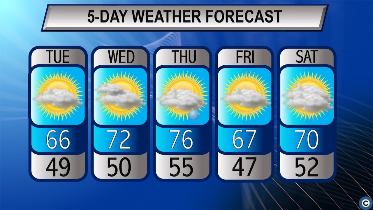
WeatherNortheast Ohio's stretch of mild, mostly dry weather continues, with temperatures climbing from the 60s Tuesday into the 70s Wednesday and Thursday. Highs could approach record levels Thursday before cooling slightly ahead of a mostly dry Halloween.cleveland.comCLEVELAND, Ohio — Northeast Ohio’s extended stretch of pleasant fall weather is about to get another warm boost, with temperatures climbing into the 70s and potentially approaching record highs Thursday.And for anyone making Halloween plans, the forecast continues to look promising, with mild temperatures and mostly dry conditions expected Saturday before rain chances increase heading into November.Temperatures will climb 10 to 15 degrees above normal across much of the region later this week as high pressure continues to keep significant rainfall at bay, according to the National Weather Service in Cleveland.A few showers could sneak into Northeast Ohio Thursday night, but the next widespread opportunity for rain is expected to arrive late Saturday night into Sunday.Temperatures climb toward record highs ThursdayHigh temperatures Tuesday are expected to reach the mid to upper 60s across much of Northeast Ohio, with cooler conditions along Lake Erie, particularly toward Ashtabula.National Weather ServiceTuesday will bring another pleasant fall afternoon, although temperatures will be slightly cooler following the passage of a weak cold front.Highs are expected to reach the mid to upper 60s across much of Northeast Ohio, with a mixture of sunshine and clouds. Cloud cover will gradually increase throughout the afternoon and evening, helping keep overnight temperatures in the mid 40s to lower 50s.Wednesday will start with clouds before sunshine returns during the afternoon. Temperatures will rebound into the low to mid 70s as warmer air moves into the region.Temperatures Thursday could approach record highs in Northeast Ohio, with mid 70s expected.National Weather ServiceThe warmest weather is expected Thursday, when afternoon highs could approach daily records in several Northeast Ohio communities.Temperatures are forecast to reach around 76 degrees in Cleveland and 74 around Akron and Canton, considerably warmer than the typical late-October highs of 59 and 58 degrees, respectively.The record high for Oct. 29 at Cleveland Hopkins International Airport is 78 degrees, set just two years ago in 2024. At Akron-Canton Airport, the record is 77 degrees, dating back to 1900.Although the forecast falls slightly short of those records, highs in the mid 70s would still be unusually warm for late October, when temperatures typically top out in the upper 50s.Daylight saving time ends this weekend, bringing much earlier sunsets to Northeast OhioMore 70s, little rain: Northeast Ohio’s warm fall weather stretches into HalloweenClocks ‘fall back’ for daylight saving time’s end very soonNortheast Ohio Monday weather forecast: Sunny and mildDry weather continues, but rain chances are returningThe extended dry spell has become a defining feature of Northeast Ohio’s weather during the second half of October this year.Through Monday, Cleveland Hopkins and Akron-Canton Airport had both gone nine consecutive days without measurable precipitation.The lack of recent rain has also contributed to growing monthly precipitation deficits.Cleveland has received 2.24 inches of precipitation through Monday, compared with a normal 3.12 inches for the period. Akron-Canton has recorded just 1.33 inches, well below the normal 2.90 inches.There is a small opportunity for rain Thursday night as another cold front moves south toward the region, potentially bringing scattered showers to parts of Northeast Ohio.However, the weather service expects any rainfall to be limited, with dry conditions returning Friday as high pressure builds back into the area.Temperatures will cool somewhat behind the front, although afternoon highs Friday are still expected to reach the mid to upper 60s.Will the weather cooperate for Halloween?For anyone with outdoor plans Saturday, the Halloween forecast remains encouraging.Mostly cloudy skies are expected across Northeast Ohio, with afternoon temperatures climbing into the upper 60s to around 70 degrees.And while a stray shower cannot be completely ruled out, the weather service currently expects most communities to remain dry during evening trick-or-treating.WKYC Channel 3 meteorologist Matt Wintz said Tuesday morning that most forecast models weaken an approaching area of rain as it encounters the region’s dry air, although some suggest showers could hold together.“We’ve got to watch that,” Wintz said.For now, the better chance of rain appears likely to hold off until late Saturday night, with precipitation becoming more likely Sunday as a larger weather system approaches from the west.A long-range forecast from WKYC Channel 3 shows widespread rain across Ohio and the Great Lakes on Tuesday, Nov. 3. A larger storm system could bring a wetter weather pattern to Northeast Ohio early next week, although the timing and extent of the rainfall remain uncertain.Courtesy WKYC Channel 3That system could signal a more substantial change in the weather pattern heading into the first week of November, bringing increased opportunities for rain and breezier conditions.Temperatures, however, are expected to remain relatively mild into early next week, with highs generally in the 60s.Ryan Cohick is keeping an eye on the sky as a weather reporter with cleveland.com and The Plain Dealer, Northeast Ohio's premier news and information source. Cohick has a Bachelor of Arts in English,...This article was produced with assistance from AI tools and reviewed by Cleveland.com staff.
Northeast Ohio flirts with record highs Thursday, with a mostly dry Halloween ahead
Full Article
Original Source
Read the full article at Cleveland →KhanList aggregates and links to publicly available news content. We do not host full articles from third-party sources. Always verify important information with original sources.