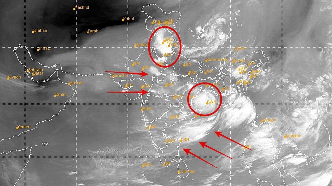
A deep depression over Odisha is driving a fresh monsoon surge across large parts of India. The spell could ease the season's 16% rainfall deficit while raising localised flood risks.The latest INSAT-3D satellite imagery shows towering thunderclouds. (Photo: IMD)India's monsoon is gathering momentum as satellite imagery captured multiple weather systems simultaneously influencing the country's rainfall, with a deep depression over Odisha emerging as the main driver of widespread showers over the next few days.Despite the renewed activity, the country continues to record a 16% rainfall deficit for the season.The latest INSAT-3D satellite imagery shows towering thunderclouds stretching across eastern, central and northern India, while the deep depression that crossed the Odisha coast has begun moving inland.The system is expected to track west-northwestwards across Odisha, east Maharashtra, south Madhya Pradesh, south Chhattisgarh and north Telangana, pumping enormous amounts of moisture into the atmosphere. Meteorologists say the interaction between the deep depression and the active monsoon flow is expected to trigger a monsoon surge, with some districts in these states likely to receive 200-400 mm of rainfall over the next three days. The India Meteorological Department (IMD) has warned that the deep depression will continue to produce moderate to heavy rainfall over Odisha during the next 24 to 36 hours, with the risk of localized flooding in low-lying areas.As the system moves inland, rainfall is also expected to intensify across central India before spreading into the northern plains.Weather models indicate that Delhi-NCR, Uttarakhand, Punjab, Himachal Pradesh and parts of western Uttar Pradesh are likely to receive widespread showers over the next 24 to 36 hours, offering relief after prolonged spells of below-normal rainfall.Satellite observations also reveal widespread convective cloud bands over the Bay of Bengal and the Indian mainland, indicating a highly active monsoon environment capable of producing thunderstorms across eastern, central, southern and northern India.RAIN DEFICIT STILL AT 16%According to the latest IMD rainfall map, India has received 335.8 mm of rainfall against a normal of 400.5 mm since the start of the monsoon season, leaving the country with an overall 16% rainfall deficit.While states such as Odisha, Jammu and Kashmir and Ladakh have recorded excess rainfall, several regions including Uttar Pradesh, Bihar, Jharkhand, Telangana, Andhra Pradesh, Karnataka and Kerala continue to face seasonal deficits.Meteorologists expect the current spell to gradually reduce the national rainfall deficit over the coming days as the deep depression continues its inland journey.If the system performs as forecast, it could significantly improve rainfall over central and northern India while replenishing reservoirs, boosting agriculture and reviving the monsoon across several rain-deficient regions.- EndsPublished By: Sibu Kumar TripathiPublished On: Jul 28, 2026 11:29 IST
Multiple monsoon systems colliding over India, rain deficit still at 16%
Full Article
Original Source
Read the full article at Indiatoday →KhanList aggregates and links to publicly available news content. We do not host full articles from third-party sources. Always verify important information with original sources.