
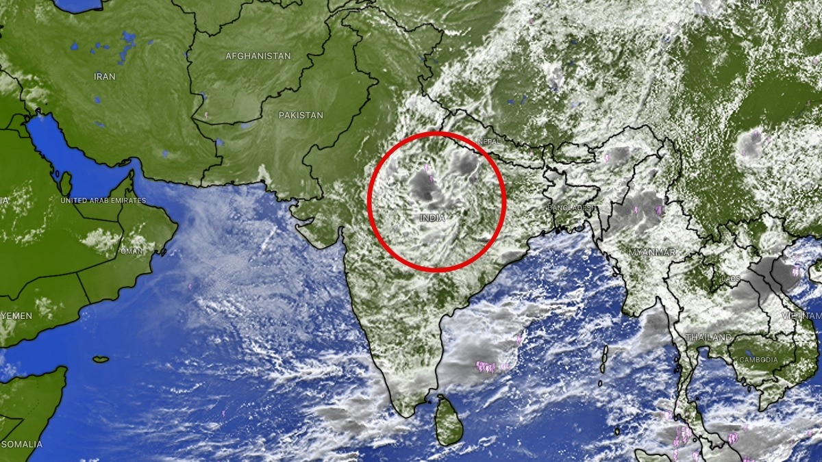
An INSAT-3DS satellite image shows a vast build-up of monsoon clouds over eastern and central India. The pattern points to more uneven rainfall, with wetter eastern areas and relatively drier western and southern regions.For Delhi-NCR, residents may also see a fresh spell of scattered rainfall. (Photo: Windy)A massive buildup of monsoon clouds over large parts of India has been captured from space, signalling another spell of rainfall activity, particularly across eastern and central parts of the country.The latest thermal infrared image from the INSAT-3DS satellite shows extensive cloud cover stretching across central India, the Indo-Gangetic plains and eastern states.Bright, dense cloud formations associated with deep convection are visible over several regions, indicating active weather systems capable of producing showers and thunderstorms.The monsoon, however, is not expected to remain equally active across the country. Weather projections indicate that East India is likely to continue receiving rainfall activity in the coming days, while Northwest India, western parts of the country and much of South India could remain relatively dry. The uneven distribution highlights the shifting nature of the monsoon, with rainfall becoming increasingly concentrated over specific regions.The satellite image shows a broad swathe of clouds extending from central India towards Bihar, Jharkhand, West Bengal and the northeastern states.Cloud activity is also visible over parts of Madhya Pradesh and adjoining regions, potentially supporting further rainfall as weather systems interact with the monsoon circulation.The active phase over East India is expected to continue through the first two weeks of September. During this period, several spells of moderate to heavy rainfall could affect parts of the region, depending on the movement and intensity of low-pressure systems and other atmospheric circulations.For Delhi-NCR, residents may also see a fresh spell of scattered rainfall. Clouds and convective activity developing during the day could trigger isolated showers and thunderstorms between late afternoon and evening hours. Such rainfall events can be highly localised, meaning some parts of the National Capital Region may receive a sharp downpour while nearby areas remain largely dry.Meanwhile, relatively drier conditions are likely to dominate parts of Northwest, West and South India compared with the wetter eastern belt.The latest view from space offers a striking snapshot of India's evolving monsoon. While vast cloud clusters continue to gather over the country's eastern half, the distribution of rainfall is becoming increasingly uneven, setting the stage for more rain in some regions and a relatively quieter weather pattern elsewhere.- EndsPublished By: Sibu Kumar TripathiPublished On: Aug 25, 2026 08:39 IST
More rain coming: Satellite captures massive cloud buildup reviving monsoon
Full Article
Original Source
Read the full article at Indiatoday →KhanList aggregates and links to publicly available news content. We do not host full articles from third-party sources. Always verify important information with original sources.