
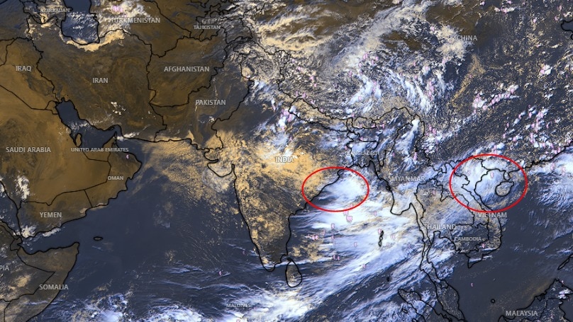
The southwest monsoon could remain active across parts of India as a weather system duo is brewing over the Bay of Bengal and the West Pacific, likely to emerge in the coming days.Meteorologists are closely tracking the evolving pattern, with an upper-air cyclonic circulation expected to form over the north Bay of Bengal towards the end of the week from August 21 to 27.A low-pressure area could subsequently develop over the northwest Bay of Bengal around the beginning of the following week. People move along the road during monsoon rain. (Photo: PTI) That does not mean a new low-pressure system has already formed. Rather, current weather models point to conditions becoming favourable for one later in the coming days. LOW-PRESSURE SYSTEMS KEEPING MONSOON ALIVEFor now, the main system affecting the weather is a well-marked low-pressure area over northeast Madhya Pradesh and adjoining areas.The monsoon trough is passing through the system and extending towards the northeast Bay of Bengal, helping maintain rainfall activity across parts of central, eastern and northern India. A satellite image shows the weather systems over the Indian subcontinent. (Photo: IMD) Such low-pressure systems are a familiar feature of the southwest monsoon, and have also been frequent this season.The systems draw moisture into the landmass and can produce widespread rainfall as they move inland.Recent systems have already delivered heavy rain across parts of eastern and central India.The current spell has included heavy to very heavy rainfall in parts of Odisha, Chhattisgarh, Madhya Pradesh and neighbouring regions, helping prevent a prolonged break in monsoon activity. Two-wheeler riders commute during a spell of heavy rain. (Photo: PTI) WHAT'S AHEAD?The IMD's forecast points to continued rainfall over large parts of eastern and central India.Sub-Himalayan West Bengal and Sikkim, Odisha, Chhattisgarh and East Madhya Pradesh are expected to see fairly widespread to widespread rain, with isolated heavy spells.Parts of East Madhya Pradesh are also facing the possibility of very heavy rainfall during the current spell. A satellite image shows the system brewing in the Bay of Bengal. (Photo: IMD) The Northeast is likely to remain active too, with Arunachal Pradesh, Assam and Meghalaya among the areas that can receive isolated heavy rainfall.The developing system in the Bay of Bengal could provide another boost to rainfall later, but its eventual strength, location and movement will become clearer only as it develops.- EndsPublished On: Aug 21, 2026 13:21 IST
More rain ahead? Twin weather systems brewing, could boost monsoon
Full Article
Original Source
Read the full article at Indiatoday →KhanList aggregates and links to publicly available news content. We do not host full articles from third-party sources. Always verify important information with original sources.