
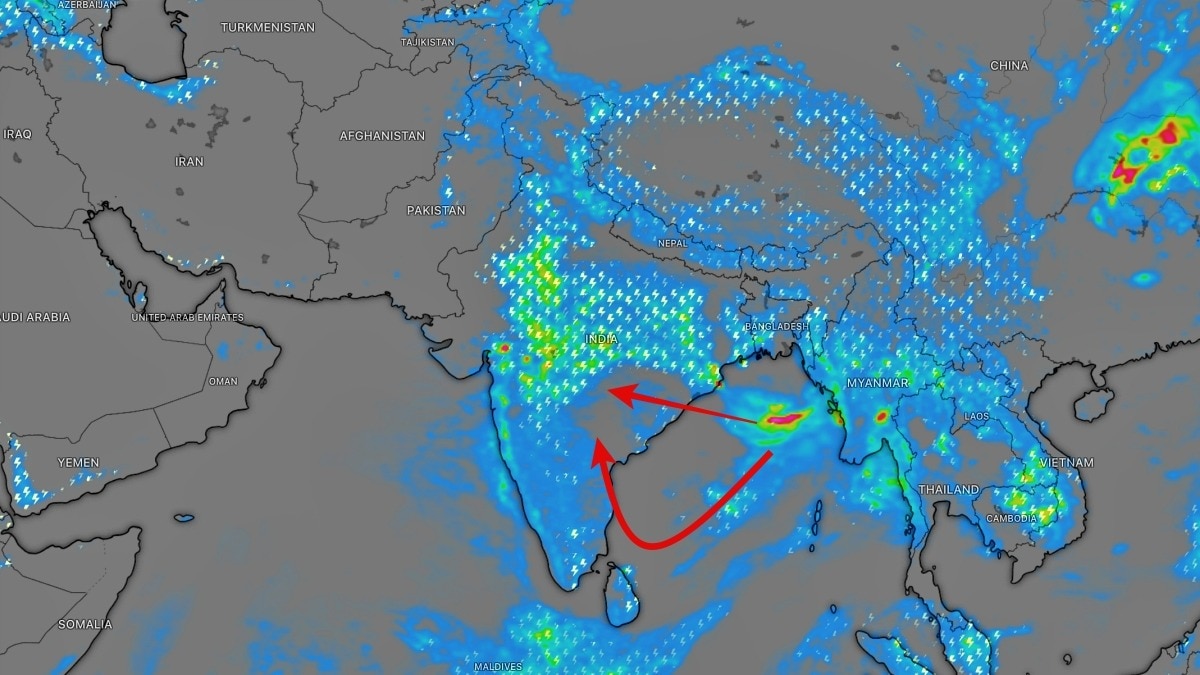
A low-pressure area is likely to form over the northwest Bay of Bengal around 12 August. It could sustain monsoon rain over Odisha and parts of eastern and central India.The low pressure system is expected to move inland. (Photo: Windy)The monsoon is showing no signs of slowing down, with the Bay of Bengal preparing to churn out another weather system that could bring heavy rain to eastern and central parts of India over the coming days.According to the latest weather outlook, a Low Pressure Area is likely to form over the northwest Bay of Bengal and adjoining areas around August 12.The developing system is expected to strengthen the monsoon circulation and draw moisture towards the eastern coast, increasing rainfall activity across the region.The first major impact is likely over Odisha, where isolated heavy to very heavy rainfall has been forecast between August 12 and 13. Some locations could experience intense downpours as the system develops and moves inland. The formation comes at a time when the monsoon trough remains active and is positioned south of its normal location in the lower levels of the atmosphere. An active and southward-shifted monsoon trough can help concentrate moisture and rising air over central and eastern India, creating favourable conditions for widespread rainfall. The Bay of Bengal is one of the key engines of the Indian summer monsoon. Low-pressure systems developing over its warm waters can transport large quantities of moisture towards the Indian landmass. As these systems move inland, they often trigger prolonged spells of rain across Odisha, Chhattisgarh, Jharkhand, Madhya Pradesh and parts of the Gangetic plains.The latest development therefore comes with the potential to keep the monsoon engine running across large parts of India, even as rainfall remains uneven from region to region.Satellite imagery is likely to show increasing cloud build-up over the northwest Bay of Bengal and adjoining eastern India as the system takes shape. The eventual track and strength of the low-pressure area will determine where the heaviest rainfall is concentrated.For Odisha, the next few days could be particularly wet, with intense rainfall raising the risk of localised flooding, waterlogging and swollen rivers and streams in vulnerable areas.The system also highlights the continuing importance of the Bay of Bengal to India's monsoon. As long as the basin continues producing low-pressure systems and the monsoon trough remains active, rainfall activity is likely to remain sustained across parts of the country.For now, all eyes are on the Bay of Bengal as another potential monsoon rainmaker takes shape.- EndsPublished By: Sibu Kumar TripathiPublished On: Aug 12, 2026 07:00 IST
Monsoon set to continue as Bay of Bengal churns new rain-loaded system
Full Article
Original Source
Read the full article at Indiatoday →KhanList aggregates and links to publicly available news content. We do not host full articles from third-party sources. Always verify important information with original sources.