
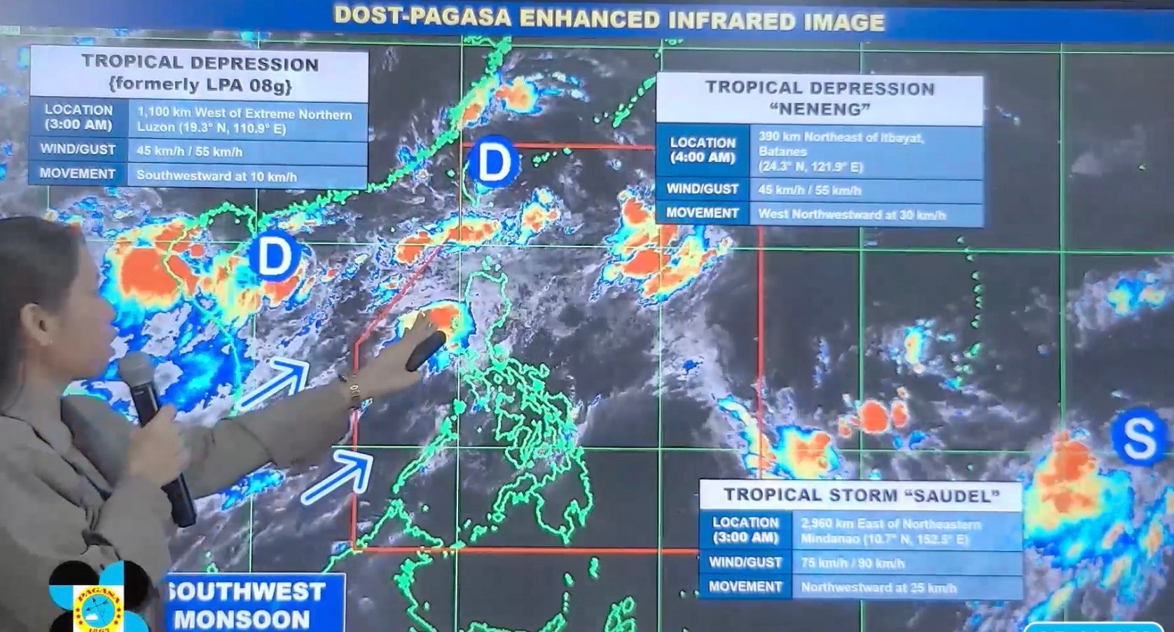
FORECAST. PAGASA Weather Specialist Leanne Loreto explains the bureau's 5 am forecast for Tropical Depression Neneng inside the Philippine Area of Responsibility, and the two tropical cyclones outside PAR, on August 20, 2026. PAGASA Portions of Northern Luzon and Central Luzon may still experience moderate to heavy rain due to the southwest monsoon on Thursday, August 20, but overall conditions are generally going to be better The weather in Luzon is expected to improve on Thursday, August 20, although some provinces may still see moderate to heavy rain due to the southwest monsoon. Tropical Depression Neneng is expected to soon weaken into a remnant low near or over Taiwan. Two other tropical cyclones are still being monitored outside the Philippine Area of Responsibility. This is AI-generated. Read the article for full context. Report any errors. MANILA, Philippines – The weather will finally begin improving on Thursday, August 20, in most areas that have been battered by the southwest monsoon or habagat in recent days. In its rainfall outlook issued at 5 am on Thursday, the Philippine Atmospheric, Geophysical, and Astronomical Services Administration (PAGASA) said there are no more areas seeing heavy to intense rain (100-200 millimeters) from the southwest monsoon. But seven provinces in Northern Luzon and Central Luzon, particularly Batanes, Ilocos Norte, Ilocos Sur, La Union, Pangasinan, Zambales, and Bataan, may still experience moderate to heavy rain (50-100 mm) on Thursday. The rest of Cagayan Valley, the rest of Central Luzon, Metro Manila, the Cordillera Administrative Region, Cavite, Batangas, Laguna, Rizal, Occidental Mindoro, Oriental Mindoro, and Palawan could have scattered rain and thunderstorms. With low-lying areas remaining vulnerable to flooding and the soil already saturated in many places, flash floods and landslides can still occur, especially during periods of moderate to heavy rain. PAGASA added that the southwest monsoon is bringing strong to gale-force gusts to these areas: Thursday, August 20 most of Luzon, most of Visayas, Zamboanga Peninsula, Northern Mindanao, Davao Region Friday, August 21 most of Luzon, Panay Island, Negros Occidental, Northern Samar, Davao Oriental Saturday, August 22 most of Luzon, most of Visayas, Davao Oriental Moderate to rough conditions will also persist in several seaboards on Thursday. Up to rough seas (small vessels should not venture out to sea) Seaboards of Batanes; northern and western seaboards of Babuyan Islands; northern seaboard of Ilocos Norte – waves up to 3.5 meters high Seaboards of Ilocos Sur, La Union, and Zambales; western seaboard of Pangasinan; northern seaboard of Kalayaan Islands; remaining seaboard of Ilocos Norte – waves up to 3 meters high Up to moderate seas (small vessels should take precautionary measures or avoid sailing, if possible) Northern seaboard of Pangasinan; western seaboard of Batangas; western and southern seaboards of Bataan; remaining seaboards of Babuyan Islands and Kalayaan Islands; seaboards of Lubang Islands – waves up to 2.5 meters high Western seaboard of Occidental Mindoro; seaboards of Surigao del Sur; northern and western seaboards of northern Palawan including Calamian Islands; eastern seaboard of Davao Oriental – waves up to 2 meters high The southwest monsoon is being pulled or influenced by Tropical Depression Neneng, which maintained its strength before dawn on Thursday. Neneng still has maximum sustained winds of 45 kilometers per hour and gustiness of up to 55 km/h. As of 4 am, it was last spotted 390 kilometers north of Itbayat, Batanes, moving west northwest at a relatively fast 30 km/h. On Thursday, the tropical depression could continue moving over the waters off Taiwan or make landfall in Taiwan, which is within the Philippine Area of Responsibility (PAR). It is also likely to weaken into a remnant low in the next 12 hours. There are no rainfall warnings or tropical cyclone wind signals raised due to Neneng, which has stayed far from Philippine landmass since it developed last Tuesday, August 18. Neneng is the Philippines’ 14th tropical cyclone for 2026, and the third tropical cyclone for August, after Tropical Depression Luis and Tropical Storm Maymay (Kujira). Two other tropical cyclones are still being monitored, both located outside PAR. The first one, which had developed over the West Philippine Sea last Tuesday, remains a tropical depression with maximum sustained winds of 45 km/h and gustiness of up to 55 km/h. It was last spotted 1,100 kilometers west of extreme Northern Luzon at 3 am on Thursday, moving southwest or away from PAR at just 10 km/h. It is heading for China or Vietnam, according to PAGASA Weather Specialist Leanne Loreto. Meanwhile, the second one is a tropical storm with the international name Saudel. Saudel was located 2,960 kilometers east of northeastern Mindanao as of 3 am on Thursday, moving northwest at 25 km/h. It still has maximum sustained winds of 75 km/h and gustiness of up to 90 km/h, but could intensify in the coming days. Loreto said Saudel could enter the northeastern corner of PAR on Sunday, August 23, or Monday, August 24, and might start enhancing the southwest monsoon. If it enters PAR, it would be given the local name Obet. But Loreto noted that there is still high uncertainty in the forecast since Saudel remains far from PAR. She advised the public to regularly monitor updates. PAGASA estimated that up to four tropical cyclones may develop within or enter PAR in August. – Rappler.com How does this make you feel? Loading
Monsoon rain starts easing; Tropical Depression Neneng nears Taiwan
Full Article
Original Source
Read the full article at Rappler →KhanList aggregates and links to publicly available news content. We do not host full articles from third-party sources. Always verify important information with original sources.