
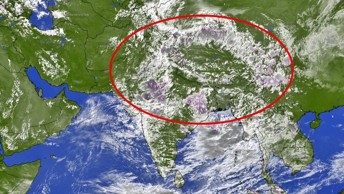
Satellite imagery has captured a vast monsoon cloud belt stretching from Pakistan across India to China. The formation points to an active monsoon spell, with heavy rain likely in parts of northern India.Recent satellite observations have highlighted such long rain bands across the region. (Photo: Windy)A massive belt of clouds stretching across northern India and deep into Asia has appeared prominently in satellite imagery, signalling an active monsoon pattern that could fuel widespread rainfall across the region.The formation seen in the satellite images is not one giant storm cloud. Instead, it is an elongated zone of deep convection and cloudiness associated with the monsoon circulation, with multiple thunderstorm and rain-bearing clusters embedded within it.In the imagery, the cloud belt begins over parts of Pakistan and northwest India, sweeps across northern and central India, climbs along the Himalayan region and extends towards Nepal, Bhutan, Tibet and China.The broader cloud shield can stretch several thousand kilometres, with similar monsoon cloud bands across Asia capable of extending over 5,000 km or more when traced eastward into China and East Asia. Recent satellite observations have highlighted such long rain bands across the region. The key feature is the concentration of bright, cold cloud tops in the infrared image. Very cold cloud tops generally indicate clouds that have grown vertically to great heights, a sign of deep convection. These towering clouds are capable of producing intense showers, thunderstorms, lightning and, in some locations, very heavy rainfall.The formation is particularly important because India is entering another active phase of the monsoon.The India Meteorological Department has forecast widespread rain and thunderstorms across several parts of the country during the current spell, including northern India.The cloud belt also shows how the monsoon does not operate as isolated weather systems. The monsoon trough acts like a conveyor belt, concentrating moisture and rising air over a broad zone. Embedded low-pressure areas, cyclonic circulations and local thunderstorms can then intensify rainfall along different portions of this belt.The satellite image shows especially extensive cloud development over north India and the Himalayan foothills, areas where moist monsoon winds interacting with the terrain can further enhance rainfall.However, the entire cloud shield will not produce continuous rain everywhere. Individual convective clusters can strengthen, weaken and move rapidly, leaving some areas under torrential rain while nearby locations receive much less.For India, the formation is a classic satellite signature of an active monsoon phase, a huge atmospheric conveyor carrying moisture across the subcontinent and towards the Himalayas.And its sheer scale is what makes the image striking: this is not just a local rain cloud, but part of a continental-scale monsoon circulation stretching thousands of kilometres across Asia.- EndsPublished By: Sibu Kumar TripathiPublished On: Aug 11, 2026 17:03 IST
Monsoon highway stretching over 5,000 km from India to China seen from space
Full Article
Original Source
Read the full article at Indiatoday →KhanList aggregates and links to publicly available news content. We do not host full articles from third-party sources. Always verify important information with original sources.