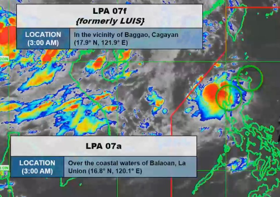
WEATHER SYSTEMS. Satellite image of the two low pressure areas, one of them formerly Tropical Depression Luis, as of August 4, 2026, 3 am. PAGASA The two low pressure areas are affecting Central Luzon and Northern Luzon on Tuesday, August 4, while the southwest monsoon is affecting portions of Southern Luzon and Western Visayas MANILA, Philippines – Tropical Depression Luis weakened into a low pressure area (LPA) while in the vicinity of Peñablanca, Cagayan, at 8 pm on Monday, August 3. The LPA that used to be Luis was already in the vicinity of Baggao, Cagayan, as of 3 am on Tuesday, August 4. Luis had made landfall in Maconacon, Isabela, at 5:30 pm on Monday, bringing torrential rain and strong winds. Hours later, Signal No. 1 was completely lifted at 11 pm, following its downgrade. Luis was the Philippines’ 12th tropical cyclone for 2026, and the first for August. The now-LPA may eventually get absorbed into the circulation of the tropical cyclone with the international name Dolphin, which is still a typhoon outside the Philippine Area of Responsibility (PAR). Another LPA also formed inside PAR on Monday evening. By 3 am on Tuesday, it was located over the coastal waters of Balaoan, La Union. The Philippine Atmospheric, Geophysical, and Astronomical Services Administration (PAGASA) said the LPA that was formerly Luis is unlikely to redevelop into a tropical cyclone, while the second LPA is also unlikely to become a tropical cyclone within 24 hours. But according to PAGASA Weather Specialist Veronica Torres, the two LPAs are causing significant rain in Central Luzon and Northern Luzon on Tuesday, particularly in the following provinces: Heavy to intense rain (100-200 millimeters): Zambales, Bataan Moderate to heavy rain (50-100 mm): Benguet, Ilocos Sur, La Union, Pangasinan, Ifugao, Mountain Province, Tarlac, Nueva Vizcaya, Nueva Ecija, Pampanga Other areas in Central Luzon, the Ilocos Region, the Cordillera Administrative Region, and Cagayan Valley not mentioned above may have scattered rain and thunderstorms due to the LPAs on Tuesday. Floods and landslides can still occur. The southwest monsoon or habagat, meanwhile, is affecting Metro Manila, Calabarzon, much of Mimaropa, and portions of Western Visayas on Tuesday. PAGASA’s latest rainfall advisory, released at 5 am on Tuesday, shows that these may be the areas most affected by the southwest monsoon over the next three days: Tuesday, August 4 Moderate to heavy rain (50-100 mm): Metro Manila, Bulacan, Cavite, Batangas, Occidental Mindoro Wednesday, August 5 Moderate to heavy rain (50-100 mm): Ilocos Norte, Ilocos Sur, Pangasinan, La Union, Zambales, Bataan, Tarlac, Benguet, Nueva Ecija, Pampanga, Batangas, Occidental Mindoro Thursday, August 6 Moderate to heavy rain (50-100 mm): Ilocos Sur, La Union, Pangasinan, Benguet, Zambales, Bataan, Batangas, Occidental Mindoro, Antique The weather bureau warned the public that rain due to the southwest monsoon may also trigger floods and landslides. PAGASA also continues to monitor Typhoon Dolphin, which was last spotted 2,330 kilometers east northeast of extreme Northern Luzon at 3 am on Tuesday, moving west at 25 kilometers per hour (km/h). Dolphin continues to have maximum sustained winds of 150 km/h and gustiness of up to 185 km/h. At its peak, it was a super typhoon. Dolphin might enter PAR, but it would just stay near the northern boundary, according to Torres. However, the typhoon is seen to enhance the southwest monsoon. If Dolphin enters PAR, it would be given the local name Maymay. PAGASA earlier said two to four tropical cyclones could develop within or enter PAR in August. – Rappler.com How does this make you feel? Loading
Luis weakens into LPA as another LPA forms; southwest monsoon also causing rain
Full Article
Original Source
Read the full article at Rappler →KhanList aggregates and links to publicly available news content. We do not host full articles from third-party sources. Always verify important information with original sources.