
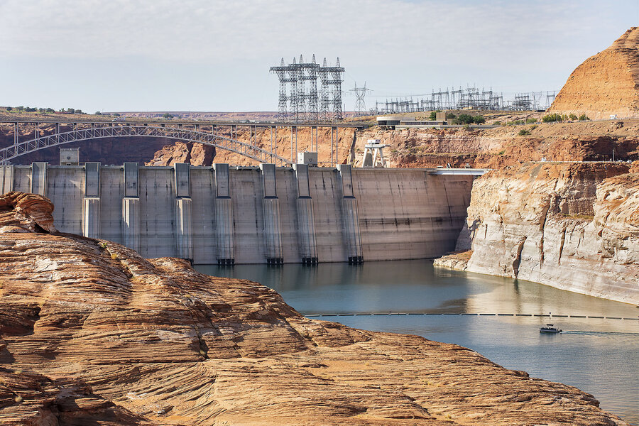
Page, Ariz. | Oct. 05, 2026, 2:07 p.m. ET | 8 min read If you lean over the top of the Glen Canyon Dam to get a full view of the concrete pillar that buttresses one of the largest dams in the United States against its second-largest reservoir, half a dozen water elevation markers will come into view. But when engineers were building Glen Canyon Dam in the mid-20th century to create another reservoir on the Colorado River, they never thought that the water would be this low. Beneath the lowest marker, there is still more than 100 feet of exposed dam before the structure disappears beneath the deep teal water of Lake Powell.The elevation in early October was 3,518 feet. That’s less than one-quarter full, lower than the prior all-time low set in 2023. By early next year, the reservoir could hit “minimum power pool” for the first time, which means the water is too low to power the dam’s eight hydroelectric turbines. Dam employees say they have no operational experience for what they’re facing now.And what Lake Powell – and the entire Colorado River – is facing now is nothing short of historic. Since 2000, the American Southwest has experienced its driest period in at least 1,200 years. Many scientists tie the length and strength of this “megadrought” to warmer temperatures from greenhouse gas emissions, which have also subsequently decreased precipitation and snowpack while making soil drier and evaporation rates higher. But the ever-growing Southwest, and its 40 million people in seven states who rely on water from the Colorado River, have continued to draw as much water as ever. For the past 25 years, they have taken out more water from the Colorado River than what has gone into it – exceeding the river’s annual supply by an average of 1 million acre-feet, which is equivalent to the amount of water used by at least 1 million suburban houses annually. Melanie Stetson Freeman/StaffMarkers on the dam depict water marks based on feet above sea level. Workers who built the dam never thought it could get as low as it is now. The jurisdictions that draw from the river – Colorado, New Mexico, Utah, Wyoming, Arizona, California, and Nevada, as well as Mexico – have been able to live above their water means for so long because of the river’s two big savings accounts: Lake Mead, which also hit a record-low in August, and Lake Powell. As recently as 1983, both reservoirs were at full capacity. Dam workers and locals in Page, Arizona, have passed down stories from the 1980s and 1990s of boaters driving right up to the dam’s concrete rim, the elevation markers fully covered by water. At the time, engineers fretted about the safest way to move so much water to the other side while maintaining the dam’s integrity. Now, they face the opposite problem. If the water continues to fall after dropping below minimum power pool, the reservoir could hit what is known as “dead pool,” meaning the trapped water is too low to flow through the dam by gravity alone. If Lake Powell reaches dead pool, the water in the reservoir would become shallow and warm, causing fish die-offs and algae blooms and becoming filled with sediment. This would also mean, of course, that the millions of people living below the dam would have no water flowing downstream. The most recent 10-year plan that dictates water allocation among the seven basin states, tribal nations, and Mexico expires at the end of this year. Some river advocates say the federal government needs to consider drastic changes – including rethinking Lake Powell’s existence. Melanie Stetson Freeman/StaffBoats travel through Lake Powell on July 16, 2026, in Page, Arizona. Much of the land now visible used to be underwater. The water levels of Lake Powell are critically low. Every drop of water within the Colorado River is still governed by the Colorado River Compact, a water-sharing agreement signed by all seven states in 1922. After much back-and-forth, then-Secretary of Commerce Herbert Hoover proposed a deal. The seven states would be divided between the upper basin (Colorado, Wyoming, New Mexico, and Utah) and the lower basin (Arizona, Nevada, and California) with the dividing line at Lees Ferry, Arizona, just south of Glen Canyon. Each basin would be able to take 7.5 million acre-feet of water from the river each year. (Tribal nations were not included in the compact’s allotments, but an annual 1.5 million acre-feet were later committed to Mexico.) These allotments seemed more than reasonable given the annual water flow at the time. But modern tree ring analyses show that these precompact years were some of the wettest on record. Although about 16.5 million acre-feet has been allocated through this century-old agreement, the average annual flow through Lees Ferry since 2000 has been under 12.5 million acre-feet. Melanie Stetson Freeman/StaffHorseshoe Bend on the Colorado River is shown July 16, 2026, in Page, Arizona. Lake Powell, which feeds into the river, is at its lowest recorded point ever. “This past year has been the worst that we’ve ever seen on the Colorado River in anybody’s lifetime,” says Mark Squillace, a professor at the University of Colorado Law School and expert in water law. “What we need of course, and everybody knows this in their heart of hearts, is we need a long-term plan.”That long-term plan could and should, depending on whom you ask, include assessing how all the Colorado River’s water is currently used. Almost all water scientists and activists point out that more than half of the river (52%) goes to irrigating agriculture. It’s not the Las Vegas Strip that’s primarily responsible for draining the river (cities in the Colorado River basin have reduced water use by 18% since 2000, despite population growth). It’s the fields of hay for cattle: 26% of the river goes to farming alfalfa, as much as one-fifth of which is shipped overseas to countries such as China and Saudi Arabia. Or, says Mr. Squillace, the seven states could scrap the “Law of the River,” the term for the century’s worth of compacts, laws, and court decisions that have allocated the Colorado River’s water with such precision that the river now runs dry at its mouth in Mexico. Instead, he says, they could adopt a “simple solution.” He suggests that a federal entity such as the Bureau of Reclamation assess how much water is available each year depending on that year’s snowpack, and then divide that among the basin states.But, it does not yet seem as if any big rethinking of the river system is in the works. Melanie Stetson Freeman/StaffBob Martin, deputy power manager of the upper Colorado River basin for the Bureau of Reclamation, stands beside a turbine on top of the Glen Canyon Dam, July 15, 2026, in Page, Arizona. After years of deadlocked negotiations, with the basin states blowing deadline after deadline to come to an agreement, the Interior Department released its own framework for a 10-year plan this summer, with specifics to be determined every two years, as well as an outline for 2027-2028. According to these plans, the lower basin (California, Arizona, and Nevada) could be forced to cut its water usage by 40% annually through 2036, and 21% over the next two years. Nevada has already sued the Interior Department. The incoming two-year plan also directs Lake Powell to maintain a minimum elevation of 3,510 feet, giving 20 feet of room to keep the dam operational. “It’s been very frustrating to watch the states’ inability to talk about a consensus approach with everyone giving something up and understanding that you have to do more with less,” says Mr. Squillace. “The water just isn’t available.”From any point on Lake Powell – whether at the rocky edge of its cliffs, or on a houseboat cruising over the cool waters, or standing atop the dam – the infamous “bathtub ring” is visible. Where the water once lapped against the sandstone walls has been turned white, offering a constant reminder of the shrinking lake. Melanie Stetson Freeman/StaffHouseboats are docked at Wahweap Marina in Lake Powell July 16, 2026. The water level is so low that boaters cannot launch from here anymore. What is now a parking area used to be underwater. Not that locals or visitors aren’t reminded in numerous other ways. The low water levels have led the National Park Service to close 14 of the lake’s 15 boat ramps and launch locations to motorized vessels. Social media videos went viral this summer showing hourslong lines of boat trailers waiting to launch at the remaining Stateline ramp, which has had to be extended as water levels drop. Currently, the lake’s elevation stands about 2 feet above the National Park Service’s minimum safe elevation for use at this last standing ramp. Tourism is down across Page, say local businesses, with visitors hesitant to rent an expensive houseboat for vacation when the water levels are dropping so precipitously. “This has always been a vacation spot, but now it looks a little different,” says Beth Henshaw, who founded the local tour company Pronghorn Expeditions this year with Jaden Games. Originally, their plan had been to start a kayaking guide business, but that felt unpredictable as well as physically difficult (many kayak guides now have to carry gear down muddy banks due to water levels, rather than drop into the lake directly), so they pivoted to more land-based recreation. Now, they offer hiking and driving tours around the lake, one of those specifically focused on Lake Powell’s changes and threats to the water system. “We’ll look at a map, and it says you’re standing underwater, but you’re not; you’re hiking,” says Ms. Henshaw. “From a recreation standpoint, it’s really fun to see it change. We get to really explore. From a residential standpoint, it’s concerning.” Melanie Stetson Freeman/Staff“We’ll look at a map, and it says you’re standing underwater, but you’re not; you’re hiking,” says Pronghorn Expeditions co-owner and guide Beth Henshaw. The changes at Lake Powell over the past two decades have come with this duality for many scientists and environmentalists. Water levels dropping so precipitously threaten entire Western communities and economies, but many can’t help but be awed by how quickly Glen Canyon has recovered ecologically as the water receded. Over the past 20 years, Davis Gulch, a canyon off the Escalante River leading into Lake Powell, has gone from fully inundated with water to a mucky mudscape. “Then you start to see the little shrubs come up knee-high,” says Eric Balken, executive director of the Glen Canyon Institute, and soon there were 30-foot willow trees with beaver ponds and birds flying overhead. “Over the course of five years, the place completely transforms, and it’s like, ‘Was there ever a reservoir here?’” says Mr. Balken. “It recovers so quickly, it’s hard to believe.” Melanie Stetson Freeman/StaffThe view as it appears from the Carl Hayden Visitor Center of Glen Canyon Dam. All of this has fueled a longtime campaign to consolidate both reservoirs into Lake Mead. Those who would like to drain Powell point to the fact that 11% of the Colorado River’s water is lost to reservoir evaporation. Combining the two bodies of water is not only physically possible (if Lake Mead took in all of Lake Powell tomorrow, it would still be less than half full), but also logical, they say, arguing that it never made sense to have these two distinct reservoirs in the first place. The reality is that they already act as “one giant storage facility,” says Jack Schmidt, director of the Center for Colorado River Studies at Utah State University.But consolidating Lake Powell into Lake Mead would devastate recreationists who have enjoyed the area for generations, and the town of Page would lose most of its economy as well as its energy supply. Lowering levels in the reservoir would make the water entering the Grand Canyon warmer, likely disrupting fisheries. And engineers say decommissioning a dam is difficult and expensive. Melanie Stetson Freeman/StaffTourists at Carl Hayden Visitor Center look out on the Glen Canyon Dam. Because of the original natural beauty of this place, with its hidden side canyons, petroglyphs, and cottonwood trees, the flooding of Glen Canyon for Lake Powell has always been controversial. American explorer John Wesley Powell (for whom the reservoir is named) described the area as “a land of beauty and glory” during his 1869 survey. Deepen your worldviewwith Monitor Highlights.Politics with respectGet political stories with respectful analysis.There‘s a world of new ideas in everyBooks newsletter.There‘s more to life, enrich yours withCulture & Learning weekly.Follow humanity‘s discoveries withScience & Nature stories in your inbox.Gain a spiritual perspectivefrom the stories in your inbox.Want to understand the deeper impact of critical events? Learn the Monitor‘s insight.Already a subscriber? Log in to hide ads. A century later, efforts by the Sierra Club’s first executive director, David Brower, to protect Dinosaur National Monument from a potential dam led to the compromised development of Glen Canyon Dam, which the environmentalist called “the greatest sin I ever committed.”But imagining a future for the canyon without the reservoir has felt “pretty hypothetical,” says Mr. Balken. Until now. “We are now exiting the hypothetical and entering a brave new world,” he says. “From our perspective, there is a huge opportunity to foster the rebirth of a national park.” ALREADY A SUBSCRIBER? LoginReal news can be honest, hopeful, credible, constructive.The Christian Science Monitor was founded in 1908 to lift the standard of journalism and uplift humanity. We aim to “speak the truth in love.” Our goal is not to tell you what to think, but to give you the essential knowledge and understanding to come to your own intelligent conclusions. Join us in this mission by subscribing.
Low water levels, high demand force a reckoning for the Colorado River
Full Article
Original Source
Read the full article at Csmonitor →KhanList aggregates and links to publicly available news content. We do not host full articles from third-party sources. Always verify important information with original sources.