
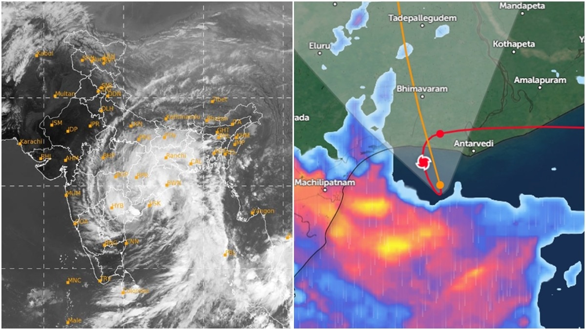
Cyclone Arnab’s slow movement along the Andhra Pradesh coast on Wednesday left people tracking its path confused.Radar images appeared to show the storm’s centre edging towards land, bending near the shoreline and then moving inland. The unusual track, however, fuelled speculation that the cyclone had made two landfalls within hours. People walk amid strong winds and rainfall during Cyclone Arnab's landfall, in Kakinada, Andhra Pradesh. (Photo: PTI) The India Meteorological Department (IMD), however, described a single, prolonged landfall, but the storm’s rather unusual path can be explained by its own movement.CYCLONE ARNAB'S UNUSUAL PATHAs Arnab approached the coast of Andhra Pradesh, its centre remained very close to the shoreline while parts of its cloud bands and rain bands had already moved inland. This meant the storm was interacting with land even as its central region remained over the sea or close to the coast. A radar image shows the path of Cyclone Arnab. (Photo: Google Earth) When a cyclone moves slowly, its centre can appear to linger or change direction slightly on a track map. Such movements can make radar animations confusing, particularly when viewed without the accompanying weather bulletins.The apparent bend in Arnab’s path therefore needed to be understood alongside the IMD’s observations, rather than interpreted on its own as proof of a second crossing.A PROLONGED LANDFALL According to the IMD, very severe cyclonic storm Arnab crossed the Andhra Pradesh and Yanam coasts between approximately 2 am and 8 am IST on Wednesday, October 28.The storm crossed southwest of Yanam, with its centre passing near a location about 20 km east-northeast of Narsapur, 40 km southwest of Yanam and 60 km southwest of Kakinada. A satellite image shows Cyclone Arnab over the Indian subcontinent. (Photo: IMD) During the crossing, Arnab packed sustained winds of 125–135 kmph, with gusts reaching 150 kmph. The IMD said the landfall process was complete by 8 am, when the cyclone’s central region had moved entirely over land.The department had also noted that the system remained practically stationary near the coast for several hours before moving northwestwards.WHY DID CYCLONE'S ARNAB CROSSING TAKE SO LONG?A cyclone’s landfall is not an instantaneous event, but a process during which the storm’s central region crosses the coastline.When a system moves slowly and stays close to shore, that process can stretch over several hours. People ride a bike amid gusty winds as Cyclone Arnab approached Andhra Pradesh's coast. (Photo: PTI) Arnab’s slow movement meant coastal areas faced prolonged exposure to strong winds and heavy rain. Its northern rain bands had already extended inland while the centre remained close to the shoreline.By 8:30 am, the IMD had downgraded Arnab to a severe cyclonic storm as it continued moving inland.The unusual-looking track was therefore consistent with a slow, drawn-out crossing, rather than evidence of the cyclone returning to open water for a second landfall.- Ends
It entered India, left, then entered again: Cyclone Arnab's unique track
Full Article
Original Source
Read the full article at Indiatoday →KhanList aggregates and links to publicly available news content. We do not host full articles from third-party sources. Always verify important information with original sources.