
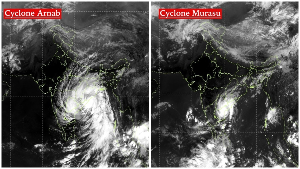
INSAT-3DS images captured contrasting cloud structures in Cyclones Murasu and Arnab. The comparison shows differing intensity and landfall characteristics despite a shared Bay of Bengal origin.The thermal infrared images, captured on October 28 and November 3, 2026, offer a glimpse into the contrasting atmospheric structures of the two weather systems. (Photo: IMD)New Delhi,Nov 3, 2026 11:19 ISTIndia's weather satellite has captured a striking difference between two cyclones that developed over the Bay of Bengal within less than a week and threatened India's eastern coastline.Satellite images from ISRO's INSAT-3DS show how Cyclone Murasu and Cyclone Arnab, despite sharing a similar origin and a landfall trajectory along the Andhra Pradesh coast, developed distinctly different cloud structures.The thermal infrared images, captured on October 28 and November 3, 2026, offer a glimpse into the contrasting atmospheric structures of the two weather systems.The October 28 image, captured between 9:30 am and 9:57 am IST, shows Cyclone Arnab's extensive cloud mass spread across the Bay of Bengal and adjoining parts of the Indian peninsula. Its cloud bands appear broad and sprawling, with deep convection extending over a large area. Cyclone Murasu after landfall. (Photo: IMD) The system's cloud shield also stretches well beyond its immediate centre, indicating a widespread zone of disturbed weather.In contrast, the November 3 image, captured between 10 am and 10:27 am IST, shows Cyclone Murasu with a comparatively compact concentration of intense cloud activity near southern Andhra Pradesh. The brightest cloud formations are concentrated around the system's core, while its associated cloud bands extend southwards and southeastwards over the Bay of Bengal.The difference is also visible in the geographical spread of the cloud formations. Arnab's cloud mass covered a wider region, while Murasu's most intense convection appears more concentrated around its centre. This suggests that the two systems had different cloud organisation at the time the images were captured. Cyclone Arnab after landfall. (Photo: IMD) The difference extended to their intensity and landfall locations.Cyclone Arnab crossed the Andhra Pradesh and Yanam coasts as a Very Severe Cyclonic Storm, packing sustained winds of 125-135 kmph and gusts reaching 150 kmph.Murasu, meanwhile, made landfall near Ongole in Prakasam district during the early hours of November 3. It crossed the south Andhra Pradesh coast between Nellore and Narsapur as a Severe Cyclonic Storm, with wind speeds of 100-110 kmph and gusts reaching 120 kmph.Despite their differences, both systems followed a similar broad pathway, developing over the Bay of Bengal before moving towards the Andhra Pradesh coastline.Their close succession also highlights the vulnerability of India's eastern coast to repeated cyclonic disturbances during the post-monsoon season.WHAT THE SATELLITE IMAGES TELL USINSAT-3DS carries thermal infrared imaging capabilities that help meteorologists monitor cloud-top temperatures, convection and the evolution of weather systems.In thermal infrared imagery, brighter regions generally represent colder cloud tops, often associated with deep convective clouds.However, cloud brightness alone cannot establish a cyclone's wind speed or intensity. Meteorologists combine satellite imagery with observations from Doppler weather radars, ocean buoys and other meteorological instruments to assess a cyclone's strength and movement.The two images, therefore, offer an important visual comparison: two cyclones originating in the same basin and striking the same coastline, but displaying different cloud structures, intensity and landfall characteristics.- Ends
Isro satellite reveals how Cyclone Murasu is different from Cyclone Arnab
Full Article
Original Source
Read the full article at Indiatoday →KhanList aggregates and links to publicly available news content. We do not host full articles from third-party sources. Always verify important information with original sources.