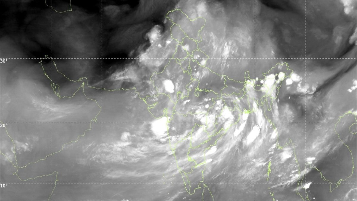
Isro satellites show 88 to 92% of India is still under cloud cover, down slightly from a 95% peak days ago, and IMD's latest forecast says extremely heavy rain is continuing over Odisha and Gujarat this week.Isro satellite images show 88 to 92% of India is still under cloud cover, down from a 95% peak days ago, and IMD's latest forecast says extremely heavy rain is continuing right now over Odisha and Gujarat. (GIF: IMD)Four days ago, India's landmass nearly vanished from view from the skies. The Indian Space Research Organisation (Isro)'s weather satellites, parked far above the equator, found almost nowhere left to look through, as a cloud sheet stretched from the Arabian Sea to the Bay of Bengal and covered close to 95 per cent of the country.That peak has passed, but the sheet has not broken up. Based on the latest thermal infrared, cloud top brightness temperature and water vapour imagery captured by Isro's Insat 3DR and Insat 3DS satellites, and released through the India Meteorological Department (IMD), somewhere between 88 and 92 per cent of India's landmass, call it roughly 90 per cent, is under cloud cover at this moment.Both figures come from reading separate satellite channels closely against IMD's own written bulletins, rather than a single official pixel-count released for public use, so they are close, defensible estimates rather than laboratory-grade readings.So to be clear: 95 per cent was the peak, recorded around 21 to 22 July. Roughly 90 per cent is where things stand today, a slight easing, not a clearing. And a cloud sheet still this large is never just scenery. It is fuel, hanging over the country right now, waiting to fall. IMD's latest bulletin spells out exactly where that fall is headed over the coming week. WHAT DOES TODAY'S CLOUD COVER LOOK LIKE FROM SPACE?The latest thermal infrared images show clouds still dominating central and eastern India, Bay of Bengal and the northeast, with a dense, cold cluster visible over the Odisha-Andhra coast. Western Rajasthan and parts of the desert belt remain the clearest patches on the map, much as they were during the earlier peak.That pattern traces the monsoon trough, a belt of low pressure across northern India that governs where rain falls in the days ahead, not just where cloud sits today. Cloud top brightness temperature imagery showing the coldest cloud tops sitting directly over the Odisha-Andhra coast. (Photo: IMD) The IMD's latest bulletin places the trough south of its normal position, with a low-pressure area that formed over the northwest Bay of Bengal and adjoining West Bengal coast now lying over that same stretch of coast.This system, the IMD says, is likely to meander over the same region and become more marked over the next two to three days, which means the cloud sitting over eastern India right now is set to intensify rather than clear.HOW MUCH RAIN WILL THIS LEVEL OF CLOUD COVER BRING OVER THE COMING WEEK?The IMD's seven-day rainfall forecast, issued alongside this imagery, gives a direct, region-by-region answer for what happens next.Himachal Pradesh, Jammu and Kashmir, and Uttarakhand are forecast to get fairly widespread to widespread rain through the end of the month, with isolated heavy rainfall continuing for most of that period. Water vapour imagery showing dry air still sitting over Pakistan and western Rajasthan while the rest of India stays moist. (Photo: IMD) Chhattisgarh and East Madhya Pradesh face a similar run of widespread rain across nearly the entire seven-day outlook, while Odisha, sitting directly beneath the strengthening low-pressure system, is forecast to get very heavy rainfall.By contrast, the IMD's forecast keeps south peninsular India, including Tamil Nadu, Rayalaseema and interior Karnataka, largely in the "isolated to scattered" category through the coming week, the driest classification on its scale, confirming the coming rain will follow the same uneven pattern the satellite images already show.WHERE WILL THE HEAVIEST RAIN LAND OVER THE NEXT FEW DAYS?The clue sits in cloud top brightness temperature, or CTBT, which tells forecasters how tall a cloud has grown, using a simple rule of physics: air cools as it rises, right up to a layer called the tropopause, roughly the ceiling of the atmosphere that makes our weather.The colder a cloud's top reads from space, the taller and more capable of heavy rain it is. An Isro Insat 3DS thermal image showing close to 90 per cent of India still under monsoon cloud cover, eased slightly from an earlier 95 per cent peak. (GIF: IMD) The latest CTBT imagery shows the coldest, tallest cloud tops sitting over the Odisha-Andhra coast and the Bay of Bengal, exactly where the IMD's low-pressure system now sits.With that system expected to become more marked over the next two to three days rather than weaken, Odisha and the surrounding coast should expect the current spell of extremely heavy rainfall to continue before any easing.WILL THE WESTERN DRY POCKET STAY DRY OVER THE COMING WEEK?Largely, yes, though not entirely. The latest water vapour imagery still shows a long, dark band of dry air sitting over Pakistan, Afghanistan and India's own north-western desert.The IMD's forecast reflects this, keeping West Rajasthan mostly in the "isolated to scattered" rainfall category through much of the coming week. There is one live exception. A low-pressure system over southwest Rajasthan is driving fresh extremely heavy rainfall. (Photo: PTI) The IMD's latest bulletin confirms a separate low-pressure area, which had earlier lain over southeast Rajasthan, has moved westward and now sits over southwest Rajasthan and neighbourhood.This system is what drove the exceptionally heavy rainfall recorded over Gujarat in the recent 24-hour period, with isolated extremely heavy rainfall likely to continue over Gujarat, even as the desert belt further west and north stays largely untouched.SO HOW LONG WILL THIS LEVEL OF CLOUD COVER AND RAIN LAST?The IMD's latest outlook does not describe conditions easing back to normal any time soon.Both the Bay of Bengal low and the Rajasthan low are forecast to remain active and intensify over the next two to three days, keeping central, eastern and northwestern India under significant cloud and rain through the end of the month.South peninsular India is expected to remain comparatively drier over the same period.Expect the next satellite pass to show cloud cover still sitting somewhere in the high 80s to low 90s, well below the peak of 95 per cent but far from clearing, with the heaviest rain continuing to track wherever these two low-pressure systems happen to sit.- EndsPublished By: Radifah KabirPublished On: Jul 26, 2026 13:29 IST
Isro images show 90% of India is under cloud cover. How much rain is likely?
Full Article
Original Source
Read the full article at Indiatoday →KhanList aggregates and links to publicly available news content. We do not host full articles from third-party sources. Always verify important information with original sources.